Byers Canyon Topo Map Nevada
To zoom in, hover over the map of Byers Canyon
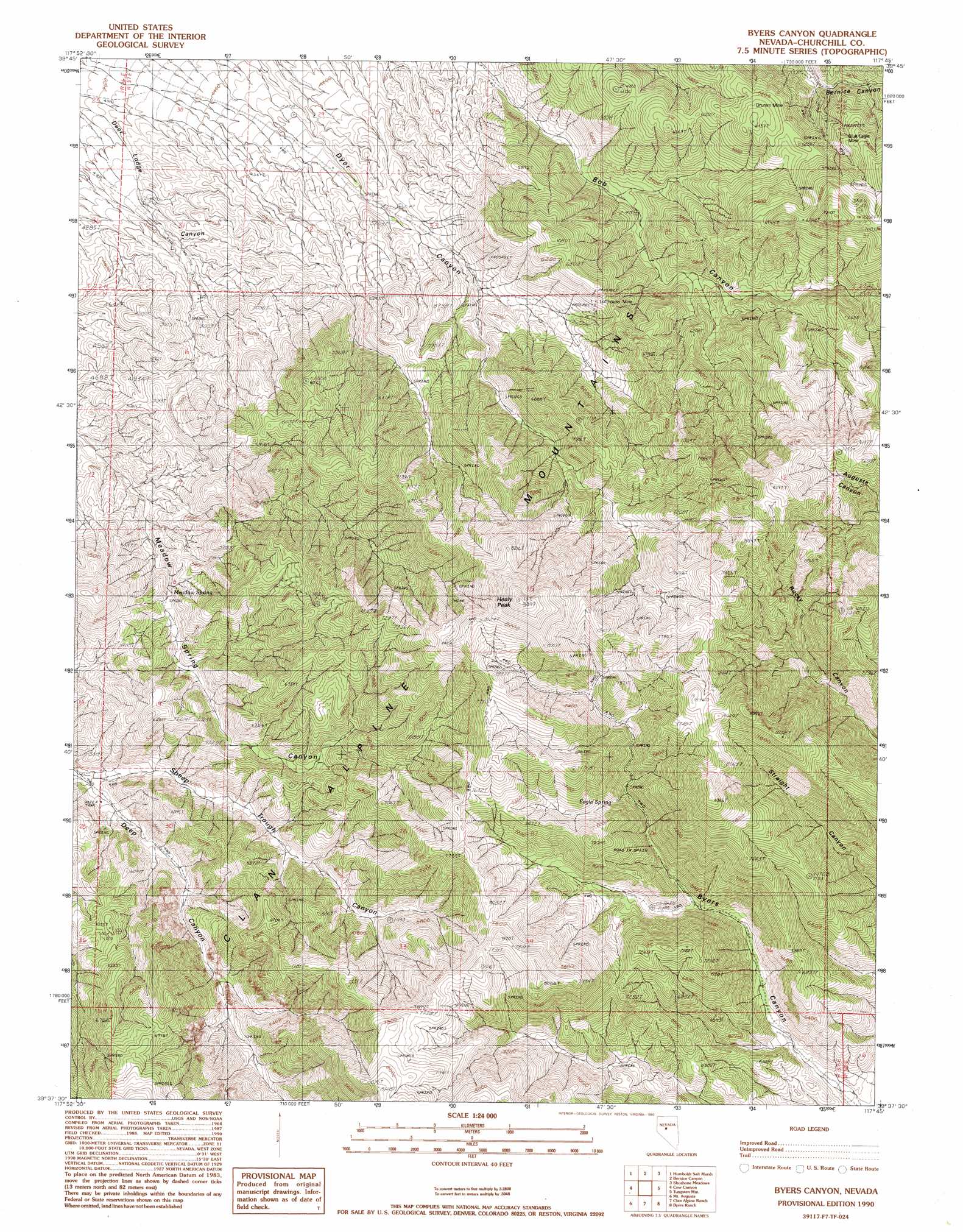
USGS Topo Quad 39117f7 - 1:24,000 scale
| Topo Map Name: | Byers Canyon |
| USGS Topo Quad ID: | 39117f7 |
| Print Size: | ca. 21 1/4" wide x 27" high |
| Southeast Coordinates: | 39.625° N latitude / 117.75° W longitude |
| Map Center Coordinates: | 39.6875° N latitude / 117.8125° W longitude |
| U.S. State: | NV |
| Filename: | o39117f7.jpg |
| Download Map JPG Image: | Byers Canyon topo map 1:24,000 scale |
| Map Type: | Topographic |
| Topo Series: | 7.5´ |
| Map Scale: | 1:24,000 |
| Source of Map Images: | United States Geological Survey (USGS) |
| Alternate Map Versions: |
Byers Canyon NV 1990, updated 1990 Download PDF Buy paper map Byers Canyon NV 2011 Download PDF Buy paper map Byers Canyon NV 2014 Download PDF Buy paper map |
1:24,000 Topo Quads surrounding Byers Canyon
Dixie Hot Springs Ne |
Bolivia |
Boyer Ranch |
Hole In The Wall |
Shoshone Meadows Ne |
Dixie Hot Springs |
Humboldt Salt Marsh |
Bernice Canyon |
Shoshone Meadows |
Shoshone Meadows Se |
Dixie Valley |
Cow Canyon |
Byers Canyon |
Tungsten Mountain |
New Pass Well |
Dixie Valley Se |
Mount Augusta |
Clan Alpine Ranch |
Byers Ranch |
New Pass |
Wonder Mountain |
Camp Creek Canyon |
Cold Springs |
Basque Summit |
Carroll Summit Ne |
> Back to 39117e1 at 1:100,000 scale
> Back to 39116a1 at 1:250,000 scale
> Back to U.S. Topo Maps home
Byers Canyon topo map: Gazetteer
Byers Canyon: Mines
Blue Eagle Mine elevation 1902m 6240′Drumm Mine elevation 1808m 5931′
Lofthouse Mine elevation 1808m 5931′
Byers Canyon: Springs
Deer Lodge Spring elevation 2464m 8083′Eagle Spring elevation 2044m 6706′
Granite Spring elevation 2186m 7171′
Sheep Trough Spring elevation 2374m 7788′
Straight Canyon Spring elevation 2130m 6988′
Yankee Spring elevation 2265m 7431′
Byers Canyon: Summits
Healy Peak elevation 2696m 8845′Byers Canyon: Valleys
Byers Canyon elevation 1691m 5547′Sheep Trough Canyon elevation 1522m 4993′
Byers Canyon digital topo map on disk
Buy this Byers Canyon topo map showing relief, roads, GPS coordinates and other geographical features, as a high-resolution digital map file on DVD: