Joe Eason Mountain Topo Map Nevada
To zoom in, hover over the map of Joe Eason Mountain
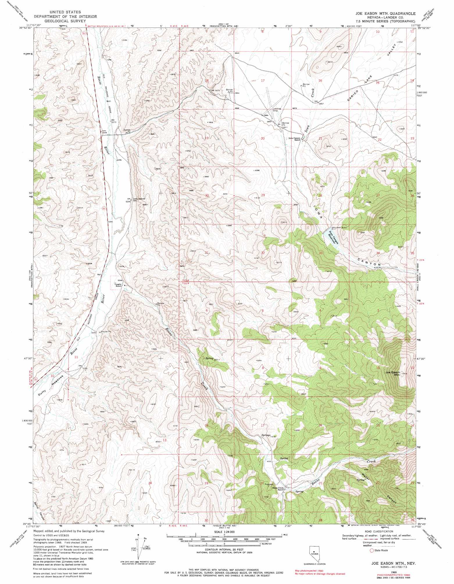
USGS Topo Quad 39117g1 - 1:24,000 scale
| Topo Map Name: | Joe Eason Mountain |
| USGS Topo Quad ID: | 39117g1 |
| Print Size: | ca. 21 1/4" wide x 27" high |
| Southeast Coordinates: | 39.75° N latitude / 117° W longitude |
| Map Center Coordinates: | 39.8125° N latitude / 117.0625° W longitude |
| U.S. State: | NV |
| Filename: | o39117g1.jpg |
| Download Map JPG Image: | Joe Eason Mountain topo map 1:24,000 scale |
| Map Type: | Topographic |
| Topo Series: | 7.5´ |
| Map Scale: | 1:24,000 |
| Source of Map Images: | United States Geological Survey (USGS) |
| Alternate Map Versions: |
Joe Eason Mtn NV 1969, updated 1971 Download PDF Buy paper map Joe Eason Mtn NV 1969, updated 1983 Download PDF Buy paper map Joe Eason Mountain NV 2011 Download PDF Buy paper map Joe Eason Mountain NV 2014 Download PDF Buy paper map |
1:24,000 Topo Quads surrounding Joe Eason Mountain
Mount Moses Se |
The Cedars Sw |
The Cedars |
Carico Lake South |
Wood Spring Canyon |
Gilbert Creek Ne |
Manhattan Mountain Nw |
Manhattan Mountain Ne |
Hall Creek North |
Corral Canyon |
Gilbert Creek Se |
Manhattan Mountain |
Joe Eason Mountain |
Hall Creek South |
Cowboy Rest Creek |
Mount Airy Ne |
Vigus Butte Nw |
Vigus Butte Ne |
Mount Callaghan |
Grass Valley Ranch |
Mount Airy Mesa |
Vigus Butte |
Yankee Blade |
Barton Spring |
Bates Mountain |
> Back to 39117e1 at 1:100,000 scale
> Back to 39116a1 at 1:250,000 scale
> Back to U.S. Topo Maps home
Joe Eason Mountain topo map: Gazetteer
Joe Eason Mountain: Airports
Iowa Canyon Ranches Landing Strip elevation 1795m 5889′Joe Eason Mountain: Dams
Iowa Creek Dam elevation 1864m 6115′Joe Eason Mountain: Flats
Duffy Meadows elevation 1636m 5367′Joe Eason Mountain: Reservoirs
Iowa Canyon Reservoir elevation 1864m 6115′Joe Eason Mountain: Streams
Boone Creek elevation 1626m 5334′Joe Eason Mountain: Summits
Joe Eason Mountain elevation 2411m 7910′Joe Eason Mountain: Valleys
Boone Canyon elevation 1643m 5390′Iowa Canyon elevation 1803m 5915′
Picket Canyon elevation 1891m 6204′
Reese River Valley elevation 1661m 5449′
Water Canyon elevation 1918m 6292′
Joe Eason Mountain digital topo map on disk
Buy this Joe Eason Mountain topo map showing relief, roads, GPS coordinates and other geographical features, as a high-resolution digital map file on DVD: