Bolivia Topo Map Nevada
To zoom in, hover over the map of Bolivia
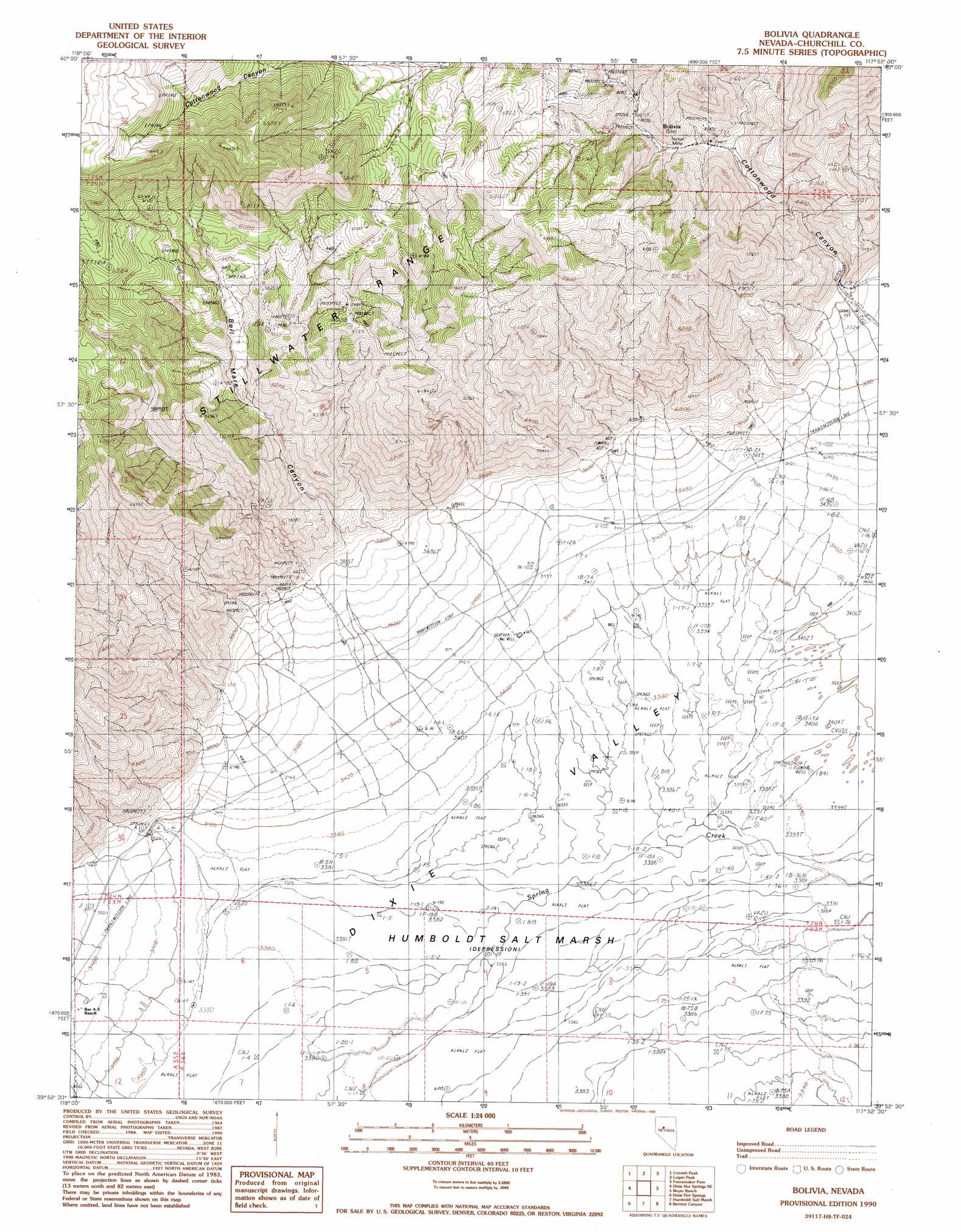
USGS Topo Quad 39117h8 - 1:24,000 scale
| Topo Map Name: | Bolivia |
| USGS Topo Quad ID: | 39117h8 |
| Print Size: | ca. 21 1/4" wide x 27" high |
| Southeast Coordinates: | 39.875° N latitude / 117.875° W longitude |
| Map Center Coordinates: | 39.9375° N latitude / 117.9375° W longitude |
| U.S. State: | NV |
| Filename: | o39117h8.jpg |
| Download Map JPG Image: | Bolivia topo map 1:24,000 scale |
| Map Type: | Topographic |
| Topo Series: | 7.5´ |
| Map Scale: | 1:24,000 |
| Source of Map Images: | United States Geological Survey (USGS) |
| Alternate Map Versions: |
Bolivia NV 1990, updated 1990 Download PDF Buy paper map Bolivia NV 2011 Download PDF Buy paper map Bolivia NV 2014 Download PDF Buy paper map |
1:24,000 Topo Quads surrounding Bolivia
Buffalo Mountain |
Fisher Canyon |
West Of Mckinney Pass |
Mckinney Pass |
Sou Hills |
Buena Vista Hills North |
Cornish Peak |
Logan Peak |
Fencemaker Pass |
Sou Hot Springs |
Buena Vista Hills South |
Dixie Hot Springs Ne |
Bolivia |
Boyer Ranch |
Hole In The Wall |
Fondaway Canyon |
Dixie Hot Springs |
Humboldt Salt Marsh |
Bernice Canyon |
Shoshone Meadows |
I X L Canyon |
Dixie Valley |
Cow Canyon |
Byers Canyon |
Tungsten Mountain |
> Back to 39117e1 at 1:100,000 scale
> Back to 39116a1 at 1:250,000 scale
> Back to U.S. Topo Maps home
Bolivia topo map: Gazetteer
Bolivia: Basins
Dixie Valley elevation 1034m 3392′Bolivia: Mines
Boyer Copper Mine elevation 1764m 5787′Lovelock Mine elevation 1448m 4750′
Nickel Mine elevation 1362m 4468′
Bolivia: Populated Places
Bolivia (historical) elevation 1416m 4645′Bolivia: Post Offices
Nickle Post Office (historical) elevation 1416m 4645′Bolivia: Summits
Pine Mountain elevation 2248m 7375′Bolivia: Valleys
Cottonwood Canyon elevation 1164m 3818′White Rock Canyon elevation 1049m 3441′
Bolivia digital topo map on disk
Buy this Bolivia topo map showing relief, roads, GPS coordinates and other geographical features, as a high-resolution digital map file on DVD: