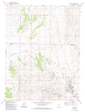
Rawhide Topo Map Nevada
To zoom in, hover over the map of Rawhide
USGS Topo Quad 39118a4 - 1:24,000 scale
| Topo Map Name: | Rawhide |
| USGS Topo Quad ID: | 39118a4 |
| Print Size: | ca. 21 1/4" wide x 27" high |
| Southeast Coordinates: | 39° N latitude / 118.375° W longitude |
| Map Center Coordinates: | 39.0625° N latitude / 118.4375° W longitude |
| U.S. State: | NV |
| Filename: | o39118a4.jpg |
| Download Map JPG Image: | Rawhide topo map 1:24,000 scale |
| Map Type: | Topographic |
| Topo Series: | 7.5´ |
| Map Scale: | 1:24,000 |
| Source of Map Images: | United States Geological Survey (USGS) |
| Alternate Map Versions: |
Rawhide NV 1980, updated 1980 Download PDF Buy paper map Rawhide NV 1980, updated 1983 Download PDF Buy paper map Rawhide NV 2011 Download PDF Buy paper map Rawhide NV 2014 Download PDF Buy paper map |
1:24,000 Topo Quads surrounding Rawhide
> Back to 39118a1 at 1:100,000 scale
> Back to 39118a1 at 1:250,000 scale
> Back to U.S. Topo Maps home
Rawhide topo map: Gazetteer
Rawhide: Mines
Bethania Mine elevation 1574m 5164′Black Eagle Mine elevation 1574m 5164′
Bullskin Mountain Mine elevation 1574m 5164′
Flynn Mine elevation 1574m 5164′
Gold Reef Mine elevation 1574m 5164′
Grutt Mines elevation 1620m 5314′
Mascot Mine elevation 1574m 5164′
Morning Star Mine elevation 1574m 5164′
Nevada New Mines elevation 1574m 5164′
Poor Boy Mine elevation 1574m 5164′
Rawhide Mine elevation 1574m 5164′
Rawhide Victor Mine elevation 1574m 5164′
Royal Mine elevation 1574m 5164′
Scheeline Mines elevation 1599m 5246′
Seminole Regent Mine elevation 1574m 5164′
Silver Zone Mine elevation 1574m 5164′
Wash Vein Mine elevation 1574m 5164′
Rawhide: Populated Places
Rawhide elevation 1549m 5082′Rawhide: Post Offices
Rawhide Post Office (historical) elevation 1549m 5082′Rawhide: Reservoirs
National Mill Reservoir (historical) elevation 1502m 4927′Rawhide: Summits
Balloon Hill elevation 1567m 5141′Black Eagle Hill elevation 1890m 6200′
Buckskin Mountain elevation 1944m 6377′
Chicago Mountain elevation 1822m 5977′
Crazy Hill elevation 1526m 5006′
Grutt Hill elevation 1620m 5314′
Hooligan Hill elevation 1637m 5370′
Murray Hill elevation 1565m 5134′
Squaw Peak elevation 1936m 6351′
Rawhide: Valleys
Stingaree Gulch elevation 1547m 5075′Rawhide digital topo map on disk
Buy this Rawhide topo map showing relief, roads, GPS coordinates and other geographical features, as a high-resolution digital map file on DVD:


