Grimes Point Topo Map Nevada
To zoom in, hover over the map of Grimes Point
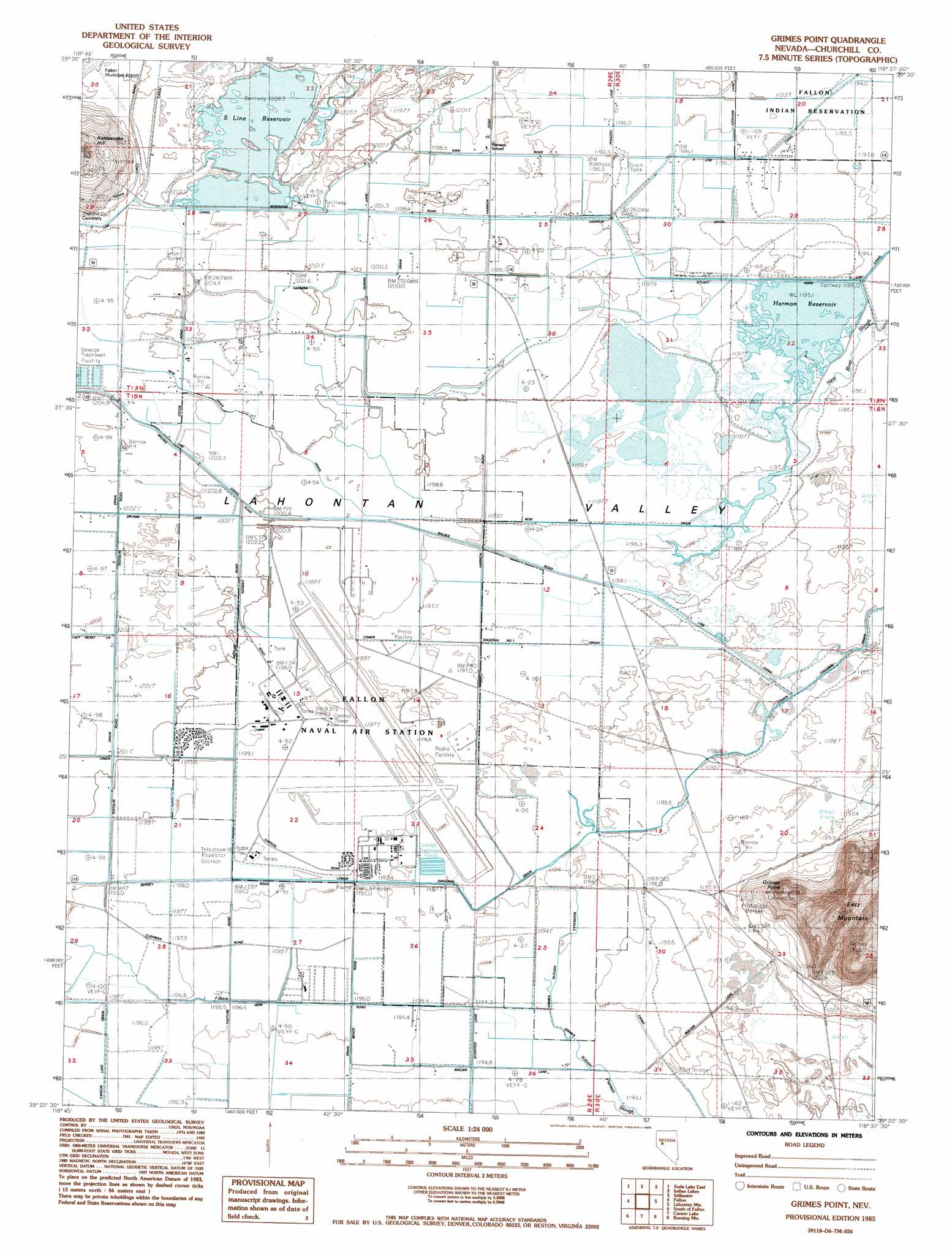
USGS Topo Quad 39118d6 - 1:24,000 scale
| Topo Map Name: | Grimes Point |
| USGS Topo Quad ID: | 39118d6 |
| Print Size: | ca. 21 1/4" wide x 27" high |
| Southeast Coordinates: | 39.375° N latitude / 118.625° W longitude |
| Map Center Coordinates: | 39.4375° N latitude / 118.6875° W longitude |
| U.S. State: | NV |
| Filename: | o39118d6.jpg |
| Download Map JPG Image: | Grimes Point topo map 1:24,000 scale |
| Map Type: | Topographic |
| Topo Series: | 7.5´ |
| Map Scale: | 1:24,000 |
| Source of Map Images: | United States Geological Survey (USGS) |
| Alternate Map Versions: |
Grimes Point NV 1985, updated 1985 Download PDF Buy paper map Grimes Point NV 2011 Download PDF Buy paper map Grimes Point NV 2014 Download PDF Buy paper map |
1:24,000 Topo Quads surrounding Grimes Point
Soda Lake Nw |
Upsal Hogback |
Battleground Point |
Stillwater Ne |
Pintail Bay |
Soda Lake West |
Soda Lake East |
Indian Lakes |
Stillwater |
Foxtail Lake |
Sheckler Reservoir |
Fallon |
Grimes Point |
Lahontan Mountains |
Diamond Canyon |
Salt Cave |
South Of Fallon |
Carson Lake |
Bunejug Mountains |
Fourmile Flat |
Wild Horse Basin |
Russell Spit |
Allen Springs |
Diamond Field Jack Wash |
Fourmile Canyon |
> Back to 39118a1 at 1:100,000 scale
> Back to 39118a1 at 1:250,000 scale
> Back to U.S. Topo Maps home
Grimes Point topo map: Gazetteer
Grimes Point: Canals
Branch 5 Drain elevation 1195m 3920′Carson Lake Drain elevation 1197m 3927′
D Canal elevation 1205m 3953′
Grimes Slough elevation 1194m 3917′
Grimes Slough Extension elevation 1195m 3920′
Harmon Drain elevation 1195m 3920′
Harmon Number One Drain elevation 1198m 3930′
L 12 Canal elevation 1196m 3923′
L 3 Drain elevation 1204m 3950′
L Drain elevation 1195m 3920′
Lower Diagonal Number 1 Drain elevation 1198m 3930′
New River Drain elevation 1203m 3946′
R Line Canal elevation 1194m 3917′
S 7 Canal elevation 1201m 3940′
S Line Canal elevation 1203m 3946′
S-One Canal elevation 1201m 3940′
S-Two Canal elevation 1196m 3923′
Grimes Point: Cliffs
Grimes Point elevation 1266m 4153′Grimes Point: Dams
S Line Dam elevation 1203m 3946′Grimes Point: Populated Places
Hill (historical) elevation 1197m 3927′Nevada City (historical) elevation 1198m 3930′
Grimes Point: Post Offices
Hill Post Office elevation 1197m 3927′Grimes Point: Reservoirs
Harmon Reservoir elevation 1197m 3927′S Line Reservoir elevation 1203m 3946′
Grimes Point: Summits
Eetz Mountain elevation 1338m 4389′Grimes Point digital topo map on disk
Buy this Grimes Point topo map showing relief, roads, GPS coordinates and other geographical features, as a high-resolution digital map file on DVD: