Marlette Lake Topo Map Nevada
To zoom in, hover over the map of Marlette Lake
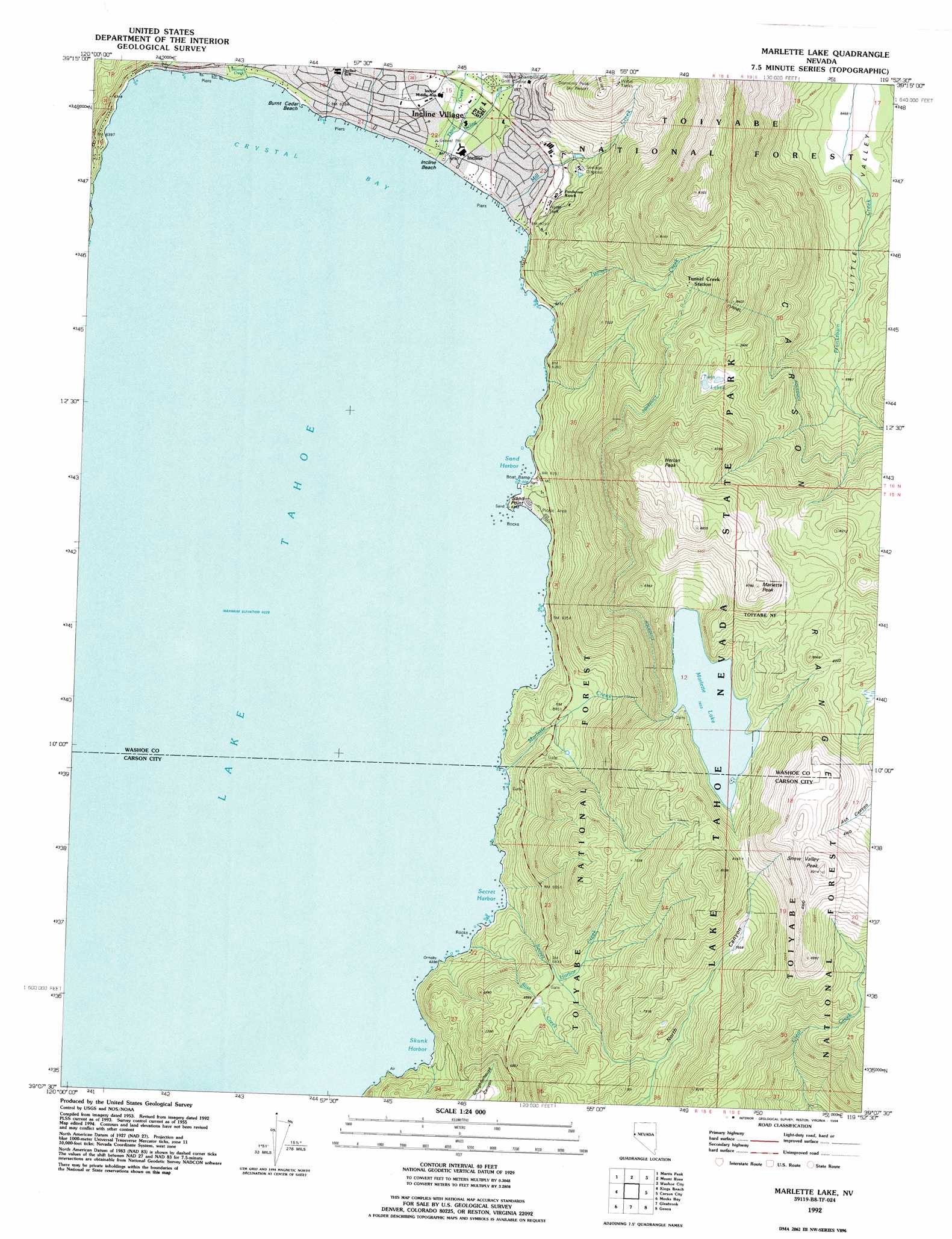
USGS Topo Quad 39119b8 - 1:24,000 scale
| Topo Map Name: | Marlette Lake |
| USGS Topo Quad ID: | 39119b8 |
| Print Size: | ca. 21 1/4" wide x 27" high |
| Southeast Coordinates: | 39.125° N latitude / 119.875° W longitude |
| Map Center Coordinates: | 39.1875° N latitude / 119.9375° W longitude |
| U.S. State: | NV |
| Filename: | o39119b8.jpg |
| Download Map JPG Image: | Marlette Lake topo map 1:24,000 scale |
| Map Type: | Topographic |
| Topo Series: | 7.5´ |
| Map Scale: | 1:24,000 |
| Source of Map Images: | United States Geological Survey (USGS) |
| Alternate Map Versions: |
Marlette Lake NV 1955, updated 1957 Download PDF Buy paper map Marlette Lake NV 1955, updated 1964 Download PDF Buy paper map Marlette Lake NV 1955, updated 1971 Download PDF Buy paper map Marlette Lake NV 1955, updated 1983 Download PDF Buy paper map Marlette Lake NV 1992, updated 1994 Download PDF Buy paper map Marlette Lake NV 1992, updated 1994 Download PDF Buy paper map Marlette Lake NV 2012 Download PDF Buy paper map Marlette Lake NV 2014 Download PDF Buy paper map |
| FStopo: | US Forest Service topo Marlette Lake is available: Download FStopo PDF Download FStopo TIF |
1:24,000 Topo Quads surrounding Marlette Lake
Hobart Mills |
Boca |
Mount Rose Nw |
Mount Rose Ne |
Steamboat |
Truckee |
Martis Peak |
Mount Rose |
Washoe City |
Virginia City |
Tahoe City |
Kings Beach |
Marlette Lake |
Carson City |
New Empire |
Homewood |
Meeks Bay |
Glenbrook |
Genoa |
Mctarnahan Hill |
Rockbound Valley |
Emerald Bay |
South Lake Tahoe |
Minden |
Gardnerville |
> Back to 39119a1 at 1:100,000 scale
> Back to 39118a1 at 1:250,000 scale
> Back to U.S. Topo Maps home
Marlette Lake topo map: Gazetteer
Marlette Lake: Basins
Summit Valley elevation 2386m 7828′Marlette Lake: Bays
Crystal Bay elevation 1900m 6233′Sand Harbor elevation 1900m 6233′
Secret Harbor elevation 1900m 6233′
Skunk Harbor elevation 1900m 6233′
Marlette Lake: Beaches
Burnt Cedar Beach elevation 1900m 6233′Hidden Beach elevation 1900m 6233′
Incline Beach elevation 1900m 6233′
Marlette Lake: Capes
Memorial Point elevation 1900m 6233′Sand Point elevation 1900m 6233′
Marlette Lake: Dams
Marlette Lake Dam elevation 2400m 7874′Mill Creek Dam Number Two elevation 1950m 6397′
Marlette Lake: Lakes
Twin Lakes elevation 2403m 7883′Marlette Lake: Mines
Little Valley Mine elevation 1973m 6473′Marlette Lake: Parks
Backcountry Management Area elevation 2462m 8077′Highway 28 Management Area elevation 1901m 6236′
Lake Tahoe State Park elevation 2402m 7880′
Sand Harbor Beach State Recreation Area elevation 1902m 6240′
Marlette Lake: Post Offices
Incline Post Office (historical) elevation 1906m 6253′Incline Village Branch Post Office elevation 1936m 6351′
Marlette Lake: Reservoirs
Marlette Lake elevation 2400m 7874′Marlette Reservoir elevation 1953m 6407′
Mill Creek Reservoir Number Two elevation 1950m 6397′
Marlette Lake: Streams
Bliss Creek elevation 1900m 6233′First Creek elevation 1900m 6233′
Incline Creek elevation 1900m 6233′
Marlette Creek elevation 1900m 6233′
Mill Creek elevation 1900m 6233′
Second Creek elevation 1901m 6236′
Secret Harbor Creek elevation 1900m 6233′
Third Creek elevation 1900m 6233′
Tunnel Creek elevation 1900m 6233′
Marlette Lake: Summits
Herlan Peak elevation 2607m 8553′Marlette Peak elevation 2661m 8730′
Snow Valley Peak elevation 2803m 9196′
Marlette Lake: Valleys
Little Valley elevation 2656m 8713′Marlette Lake digital topo map on disk
Buy this Marlette Lake topo map showing relief, roads, GPS coordinates and other geographical features, as a high-resolution digital map file on DVD: