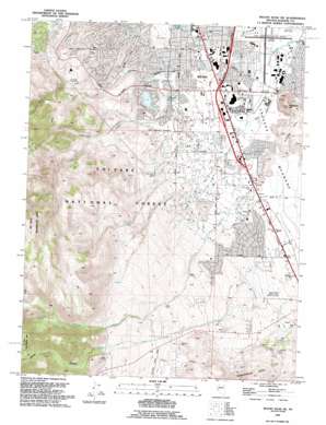
Mount Rose Ne Topo Map Nevada
To zoom in, hover over the map of Mount Rose Ne
USGS Topo Quad 39119d7 - 1:24,000 scale
| Topo Map Name: | Mount Rose Ne |
| USGS Topo Quad ID: | 39119d7 |
| Print Size: | ca. 21 1/4" wide x 27" high |
| Southeast Coordinates: | 39.375° N latitude / 119.75° W longitude |
| Map Center Coordinates: | 39.4375° N latitude / 119.8125° W longitude |
| U.S. State: | NV |
| Filename: | o39119d7.jpg |
| Download Map JPG Image: | Mount Rose Ne topo map 1:24,000 scale |
| Map Type: | Topographic |
| Topo Series: | 7.5´ |
| Map Scale: | 1:24,000 |
| Source of Map Images: | United States Geological Survey (USGS) |
| Alternate Map Versions: |
Mt. Rose NE NV 1969, updated 1972 Download PDF Buy paper map Mt. Rose NE NV 1969, updated 1977 Download PDF Buy paper map Mt. Rose NE NV 1969, updated 1980 Download PDF Buy paper map Mt. Rose NE NV 1969, updated 1983 Download PDF Buy paper map Mt. Rose NE NV 1974, updated 1977 Download PDF Buy paper map Mount Rose NE NV 1994, updated 1994 Download PDF Buy paper map Mount Rose NE NV 1994, updated 1994 Download PDF Buy paper map Mount Rose NE NV 2012 Download PDF Buy paper map Mount Rose NE NV 2014 Download PDF Buy paper map |
| FStopo: | US Forest Service topo Mount Rose NE is available: Download FStopo PDF Download FStopo TIF |
1:24,000 Topo Quads surrounding Mount Rose Ne
> Back to 39119a1 at 1:100,000 scale
> Back to 39118a1 at 1:250,000 scale
> Back to U.S. Topo Maps home
Mount Rose Ne topo map: Gazetteer
Mount Rose Ne: Airports
Cannon International Airport elevation 1342m 4402′Washoe Station Nevada Department of Wildlife Heliport elevation 1352m 4435′
Mount Rose Ne: Canals
Cochran Ditch elevation 1360m 4461′Mount Rose Ne: Dams
Wheeler Reservoir Dam elevation 1472m 4829′Mount Rose Ne: Flats
Truckee Meadows elevation 1357m 4452′Mount Rose Ne: Mines
Wheeler Ranch Prospect elevation 1607m 5272′Mount Rose Ne: Parks
Audrey Harris Park elevation 1419m 4655′Horsemans Park elevation 1478m 4849′
Moana Municipal Pool elevation 1361m 4465′
Reno Municipal Tennis Center elevation 1385m 4543′
Tigh Park elevation 1363m 4471′
Yori Park elevation 1352m 4435′
Mount Rose Ne: Populated Places
Andersons (historical) elevation 1380m 4527′Huffaker (historical) elevation 1361m 4465′
Mount Rose Ne: Post Offices
Truckee Meadows Post Office (historical) elevation 1380m 4527′Mount Rose Ne: Reservoirs
Wheeler Reservoir elevation 1472m 4829′Mount Rose Ne: Springs
Moana Hot Springs elevation 1361m 4465′Mount Rose Spring elevation 1462m 4796′
Zolezzi Springs elevation 1385m 4543′
Mount Rose Ne: Streams
Dry Creek elevation 1339m 4393′Evans Creek elevation 1409m 4622′
Thomas Creek elevation 1381m 4530′
Mount Rose Ne: Summits
Huffaker Hills elevation 1477m 4845′Rattlesnake Mountain elevation 1520m 4986′
Mount Rose Ne: Valleys
Whites Canyon elevation 1801m 5908′Mount Rose Ne: Wells
Al Koenig Well elevation 1485m 4872′Arbico Well elevation 1384m 4540′
Berrum Well elevation 1380m 4527′
Biglin Well elevation 1384m 4540′
Brown Well elevation 1384m 4540′
Campbell Well elevation 1398m 4586′
Christman Well elevation 1402m 4599′
Clark Well elevation 1384m 4540′
Clark Well elevation 1376m 4514′
Country Club Wells elevation 1384m 4540′
Cox Well elevation 1466m 4809′
Crano Wells elevation 1374m 4507′
DeGiovanni Well elevation 1385m 4543′
Drendel Well elevation 1384m 4540′
Edmiston Well elevation 1385m 4543′
Erskine Well elevation 1389m 4557′
Etcheberry Well elevation 1381m 4530′
Etnyre Well elevation 1385m 4543′
Fife Well elevation 1363m 4471′
Frey Well elevation 1380m 4527′
Gibbons Well elevation 1380m 4527′
Glatly Well elevation 1385m 4543′
Guisti Well elevation 1458m 4783′
Hall Well elevation 1388m 4553′
Helms Well elevation 1389m 4557′
Herz Well elevation 1398m 4586′
Hill Well elevation 1380m 4527′
Hobson Well elevation 1381m 4530′
Isabell Well elevation 1415m 4642′
Jack Horgan Well elevation 1431m 4694′
Johnson Well elevation 1369m 4491′
Kelty Well elevation 1384m 4540′
Kimberley Well elevation 1376m 4514′
King Well elevation 1384m 4540′
Mackay Well elevation 1411m 4629′
Martic Well elevation 1376m 4514′
Matley Well elevation 1380m 4527′
McCulloch Well elevation 1384m 4540′
McKenzie Well elevation 1409m 4622′
Mercury Well elevation 1466m 4809′
Miles Well elevation 1384m 4540′
Moana Springs Well elevation 1361m 4465′
Moana Well elevation 1381m 4530′
Moffat Well elevation 1356m 4448′
Moore Well elevation 1384m 4540′
Morrey Well elevation 1423m 4668′
Newton Well elevation 1351m 4432′
Parragari Well elevation 1389m 4557′
Pecknam Well elevation 1362m 4468′
Peigh Well elevation 1411m 4629′
Quadrio Well elevation 1392m 4566′
Randall Well elevation 1369m 4491′
Reno Press Brick Well elevation 1488m 4881′
Siri Well elevation 1389m 4557′
Smith Well elevation 1375m 4511′
Steam Wells elevation 1473m 4832′
Terrill Well elevation 1384m 4540′
University Farm Well elevation 1369m 4491′
Upton Well elevation 1381m 4530′
Van Slyck Well elevation 1369m 4491′
Yates Well elevation 1380m 4527′
Mount Rose Ne digital topo map on disk
Buy this Mount Rose Ne topo map showing relief, roads, GPS coordinates and other geographical features, as a high-resolution digital map file on DVD:


