Westville Topo Map California
To zoom in, hover over the map of Westville
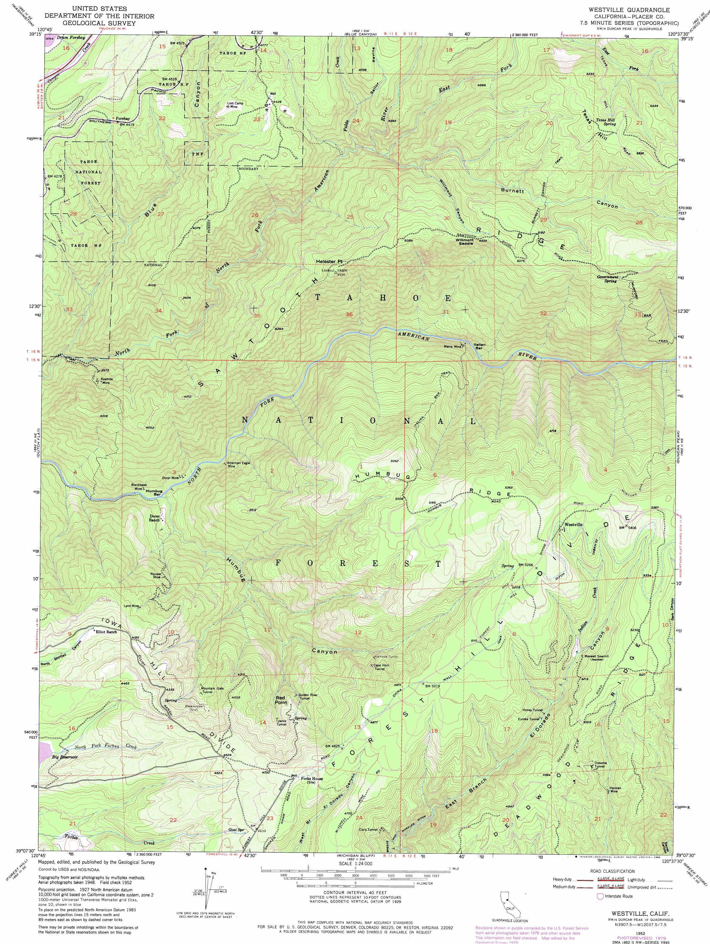
USGS Topo Quad 39120b6 - 1:24,000 scale
| Topo Map Name: | Westville |
| USGS Topo Quad ID: | 39120b6 |
| Print Size: | ca. 21 1/4" wide x 27" high |
| Southeast Coordinates: | 39.125° N latitude / 120.625° W longitude |
| Map Center Coordinates: | 39.1875° N latitude / 120.6875° W longitude |
| U.S. State: | CA |
| Filename: | o39120b6.jpg |
| Download Map JPG Image: | Westville topo map 1:24,000 scale |
| Map Type: | Topographic |
| Topo Series: | 7.5´ |
| Map Scale: | 1:24,000 |
| Source of Map Images: | United States Geological Survey (USGS) |
| Alternate Map Versions: |
Westville CA 1952 Download PDF Buy paper map Westville CA 1952, updated 1954 Download PDF Buy paper map Westville CA 1952, updated 1957 Download PDF Buy paper map Westville CA 1952, updated 1976 Download PDF Buy paper map Westville CA 1952, updated 1980 Download PDF Buy paper map Westville CA 1952, updated 1983 Download PDF Buy paper map Westville CA 1952, updated 1983 Download PDF Buy paper map Westville CA 2000, updated 2003 Download PDF Buy paper map Westville CA 2012 Download PDF Buy paper map Westville CA 2015 Download PDF Buy paper map |
| FStopo: | US Forest Service topo Westville is available: Download FStopo PDF Download FStopo TIF |
1:24,000 Topo Quads surrounding Westville
Pike |
Alleghany |
Graniteville |
English Mountain |
Webber Peak |
North Bloomfield |
Washington |
Blue Canyon |
Cisco Grove |
Soda Springs |
Chicago Park |
Dutch Flat |
Westville |
Duncan Peak |
Royal Gorge |
Colfax |
Foresthill |
Michigan Bluff |
Greek Store |
Bunker Hill |
Greenwood |
Georgetown |
Tunnel Hill |
Devil Peak |
Robbs Peak |
> Back to 39120a1 at 1:100,000 scale
> Back to 39120a1 at 1:250,000 scale
> Back to U.S. Topo Maps home
Westville topo map: Gazetteer
Westville: Bars
Humbug Bar elevation 623m 2043′Italian Bar elevation 730m 2395′
Westville: Canals
China Wall Iowa Hill Ditch elevation 1560m 5118′Westville: Cliffs
Red Point elevation 1205m 3953′Westville: Dams
Drum Forebay 97-020 Dam elevation 1447m 4747′Westville: Flats
Elliot Meadow elevation 1246m 4087′Westville: Gaps
Willmont Saddle elevation 1460m 4790′Westville: Mines
Alameda Tunnel elevation 1284m 4212′American Eagle Mine elevation 691m 2267′
Blackhawk Mine elevation 656m 2152′
Cape Horn Tunnel elevation 1317m 4320′
Dorer Mine elevation 650m 2132′
Eureka Tunnel elevation 1314m 4311′
Golden River Tunnel elevation 1148m 3766′
Herman Mine elevation 1326m 4350′
Honey Tunnel elevation 1323m 4340′
Jarvis Tunnel elevation 1206m 3956′
Lost Camp Mine elevation 1298m 4258′
Lynn Mine elevation 1245m 4084′
Marrs Mine elevation 775m 2542′
Mountain Gate Tunnel elevation 1190m 3904′
Pioneer Mine elevation 964m 3162′
Rawhide Mine elevation 904m 2965′
Westville: Populated Places
Forebay elevation 1346m 4416′Rawhide elevation 663m 2175′
Red Point (historical) elevation 1241m 4071′
Westville elevation 1600m 5249′
Westville: Post Offices
Westville Post Office (historical) elevation 1600m 5249′Westville: Reservoirs
Drum Forebay elevation 1447m 4747′Westville: Ridges
Forest Hill Divide elevation 1574m 5164′Humbug Ridge elevation 1580m 5183′
Iowa Hill Divide elevation 1437m 4714′
Sawtooth Ridge elevation 1549m 5082′
Westville: Springs
Corral Spring elevation 1574m 5164′Goat Spring elevation 1404m 4606′
Government Spring elevation 1607m 5272′
Texas Hill Spring elevation 1630m 5347′
Westville: Streams
East Fork North Fork North Fork American River elevation 1006m 3300′Fulda Creek elevation 990m 3248′
Humbug Creek elevation 622m 2040′
Indian Creek elevation 1385m 4543′
Monumental Creek elevation 1443m 4734′
Shady Run elevation 705m 2312′
Westville: Summits
Helester Point elevation 1479m 4852′Texas Hill elevation 1704m 5590′
Westville: Trails
American Eagle Trail elevation 662m 2171′American Eagle Trail elevation 1246m 4087′
Burnett Canyon Trail elevation 1557m 5108′
Euchre Bar Trail elevation 599m 1965′
Italian Bar Trail elevation 1234m 4048′
Mumford Bar Trail elevation 1191m 3907′
Westville: Tunnels
Clara Tunnel elevation 1285m 4215′Osborne Tunnel elevation 1446m 4744′
Westville: Valleys
Blue Canyon elevation 654m 2145′Burnett Canyon elevation 1016m 3333′
Humbug Canyon elevation 630m 2066′
Indian Springs Ravine elevation 1385m 4543′
Sailor Ravine elevation 1136m 3727′
Willmont Canyon elevation 1208m 3963′
Westville digital topo map on disk
Buy this Westville topo map showing relief, roads, GPS coordinates and other geographical features, as a high-resolution digital map file on DVD: