Chicago Park Topo Map California
To zoom in, hover over the map of Chicago Park
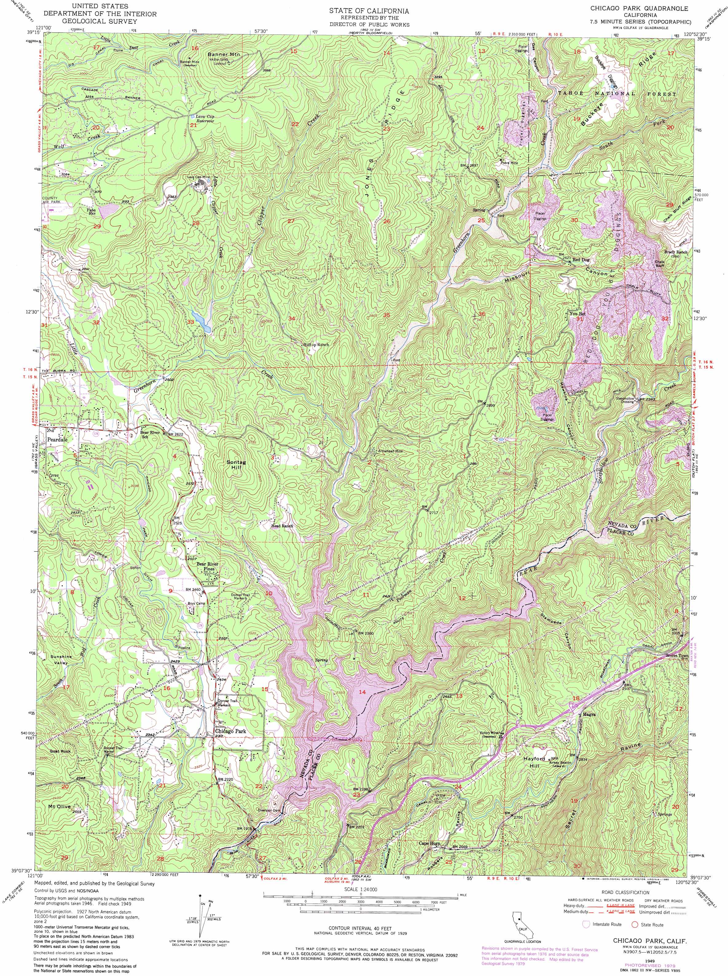
USGS Topo Quad 39120b8 - 1:24,000 scale
| Topo Map Name: | Chicago Park |
| USGS Topo Quad ID: | 39120b8 |
| Print Size: | ca. 21 1/4" wide x 27" high |
| Southeast Coordinates: | 39.125° N latitude / 120.875° W longitude |
| Map Center Coordinates: | 39.1875° N latitude / 120.9375° W longitude |
| U.S. State: | CA |
| Filename: | o39120b8.jpg |
| Download Map JPG Image: | Chicago Park topo map 1:24,000 scale |
| Map Type: | Topographic |
| Topo Series: | 7.5´ |
| Map Scale: | 1:24,000 |
| Source of Map Images: | United States Geological Survey (USGS) |
| Alternate Map Versions: |
Chicago Park CA 1949, updated 1956 Download PDF Buy paper map Chicago Park CA 1949, updated 1956 Download PDF Buy paper map Chicago Park CA 1949, updated 1967 Download PDF Buy paper map Chicago Park CA 1949, updated 1967 Download PDF Buy paper map Chicago Park CA 1949, updated 1976 Download PDF Buy paper map Chicago Park CA 1949, updated 1980 Download PDF Buy paper map Chicago Park CA 1949, updated 1980 Download PDF Buy paper map Chicago Park CA 1951 Download PDF Buy paper map Chicago Park CA 2000, updated 2003 Download PDF Buy paper map Chicago Park CA 2012 Download PDF Buy paper map Chicago Park CA 2015 Download PDF Buy paper map |
| FStopo: | US Forest Service topo Chicago Park is available: Download FStopo PDF Download FStopo TIF |
1:24,000 Topo Quads surrounding Chicago Park
Challenge |
Camptonville |
Pike |
Alleghany |
Graniteville |
French Corral |
Nevada City |
North Bloomfield |
Washington |
Blue Canyon |
Rough And Ready |
Grass Valley |
Chicago Park |
Dutch Flat |
Westville |
Wolf |
Lake Combie |
Colfax |
Foresthill |
Michigan Bluff |
Gold Hill |
Auburn |
Greenwood |
Georgetown |
Tunnel Hill |
> Back to 39120a1 at 1:100,000 scale
> Back to 39120a1 at 1:250,000 scale
> Back to U.S. Topo Maps home
Chicago Park topo map: Gazetteer
Chicago Park: Basins
Sunshine Valley elevation 619m 2030′Chicago Park: Canals
Chicago Park Ditch elevation 808m 2650′D-S Canal elevation 876m 2874′
Chicago Park: Cliffs
Chalk Bluff elevation 1060m 3477′Chicago Park: Crossings
Steeplehollow Crossing elevation 722m 2368′Chicago Park: Dams
Loma Rica Airport 61-025 Dam elevation 960m 3149′Nevada City Raw Water 2026 Dam elevation 859m 2818′
Rollins 61-021 Dam elevation 662m 2171′
Chicago Park: Mines
Arrowhead Mine elevation 718m 2355′Banner Mine elevation 1031m 3382′
Buckeye Diggings elevation 951m 3120′
Canada Hill Mine elevation 842m 2762′
Lava Cap Mine elevation 873m 2864′
Little York Diggings elevation 878m 2880′
Poore Mine elevation 846m 2775′
Red Dog You Bet Diggings elevation 895m 2936′
Victory Mine elevation 898m 2946′
Chicago Park: Populated Places
Bear River Pines elevation 763m 2503′Buena Vista (historical) elevation 802m 2631′
Cape Horn elevation 809m 2654′
Coleman elevation 777m 2549′
Hunts Hill (historical) elevation 885m 2903′
Little York (historical) elevation 892m 2926′
Magra elevation 880m 2887′
Peardale elevation 826m 2709′
Pinecrest elevation 743m 2437′
Red Dog elevation 797m 2614′
Secret Town elevation 885m 2903′
You Bet elevation 887m 2910′
Chicago Park: Reservoirs
Lava Cap Reservoir elevation 1031m 3382′Rollins Reservoir elevation 664m 2178′
Yuba Reservoir elevation 955m 3133′
Chicago Park: Ridges
Buckeye Ridge elevation 1032m 3385′Jones Ridge elevation 1015m 3330′
Chicago Park: Streams
Clipper Creek elevation 727m 2385′Greenhorn Creek elevation 662m 2171′
Little Clipper Creek elevation 751m 2463′
Little Greenhorn Creek elevation 678m 2224′
Poorman Creek elevation 668m 2191′
South Fork Greenhorn Creek elevation 764m 2506′
Steephollow Creek elevation 677m 2221′
Chicago Park: Summits
Banner Mountain elevation 1188m 3897′Goat Rock elevation 754m 2473′
Hayford Hill elevation 980m 3215′
Mount Olive elevation 785m 2575′
Sonntag Hill elevation 929m 3047′
Chicago Park: Valleys
Gas Canyon elevation 784m 2572′Hawkins Canyon elevation 712m 2335′
Missouri Canyon elevation 720m 2362′
Stampede Canyon elevation 662m 2171′
Chicago Park digital topo map on disk
Buy this Chicago Park topo map showing relief, roads, GPS coordinates and other geographical features, as a high-resolution digital map file on DVD: