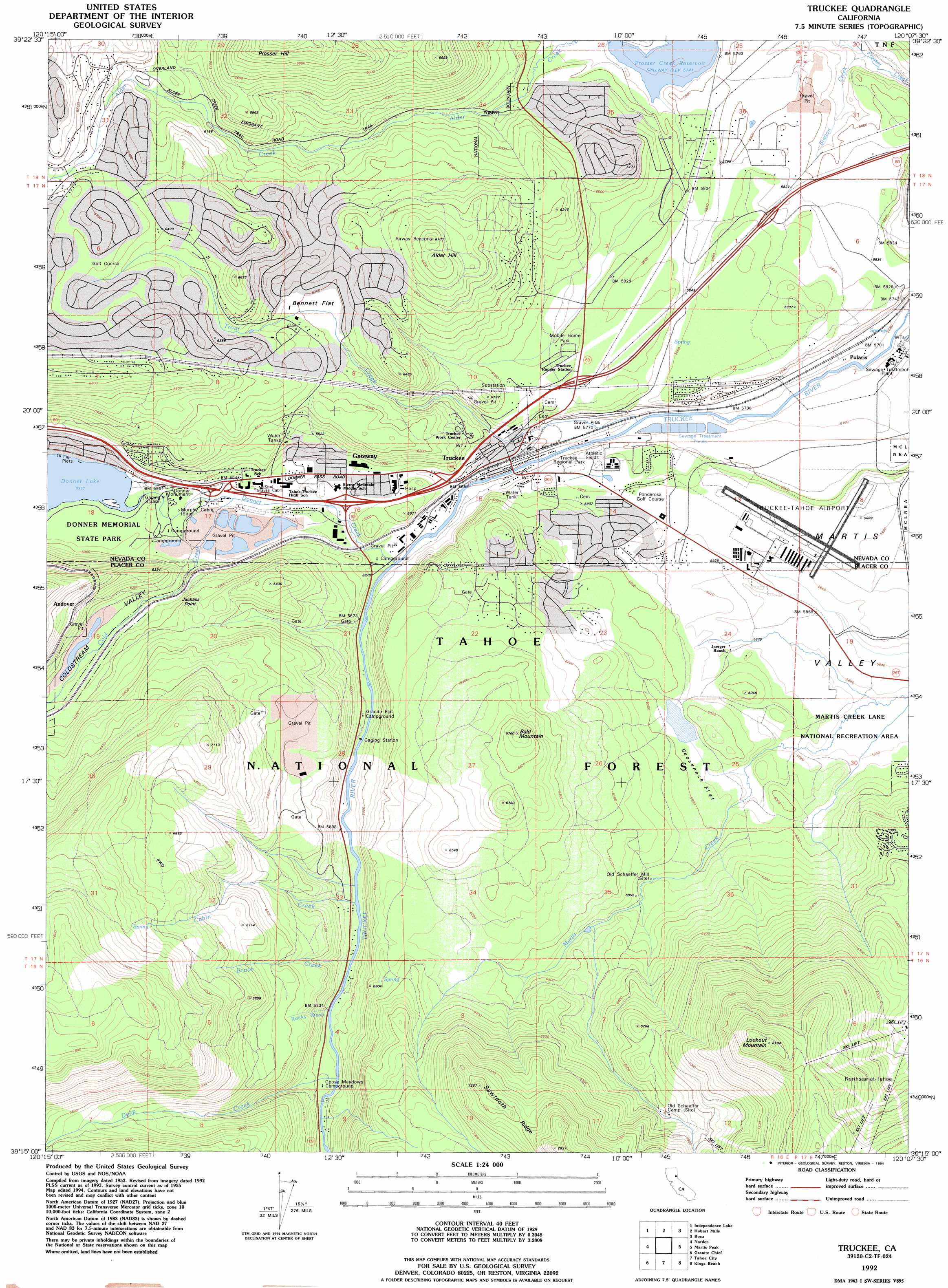
Truckee Topo Map California
To zoom in, hover over the map of Truckee
USGS Topo Quad 39120c2 - 1:24,000 scale
| Topo Map Name: | Truckee |
| USGS Topo Quad ID: | 39120c2 |
| Print Size: | ca. 21 1/4" wide x 27" high |
| Southeast Coordinates: | 39.25° N latitude / 120.125° W longitude |
| Map Center Coordinates: | 39.3125° N latitude / 120.1875° W longitude |
| U.S. State: | CA |
| Filename: | o39120c2.jpg |
| Download Map JPG Image: | Truckee topo map 1:24,000 scale |
| Map Type: | Topographic |
| Topo Series: | 7.5´ |
| Map Scale: | 1:24,000 |
| Source of Map Images: | United States Geological Survey (USGS) |
| Alternate Map Versions: |
Truckee CA 1955, updated 1956 Download PDF Buy paper map Truckee CA 1955, updated 1960 Download PDF Buy paper map Truckee CA 1955, updated 1970 Download PDF Buy paper map Truckee CA 1955, updated 1971 Download PDF Buy paper map Truckee CA 1955, updated 1986 Download PDF Buy paper map Truckee CA 1992, updated 1994 Download PDF Buy paper map Truckee CA 1992, updated 1994 Download PDF Buy paper map Truckee CA 2000, updated 2003 Download PDF Buy paper map Truckee CA 2000, updated 2003 Download PDF Buy paper map Truckee CA 2012 Download PDF Buy paper map Truckee CA 2015 Download PDF Buy paper map |
| FStopo: | US Forest Service topo Truckee is available: Download FStopo PDF Download FStopo TIF |
1:24,000 Topo Quads surrounding Truckee
Sattley |
Sierraville |
Sardine Peak |
Dog Valley |
Verdi |
Webber Peak |
Independence Lake |
Hobart Mills |
Boca |
Mount Rose Nw |
Soda Springs |
Norden |
Truckee |
Martis Peak |
Mount Rose |
Royal Gorge |
Granite Chief |
Tahoe City |
Kings Beach |
Marlette Lake |
Bunker Hill |
Wentworth Springs |
Homewood |
Meeks Bay |
Glenbrook |
> Back to 39120a1 at 1:100,000 scale
> Back to 39120a1 at 1:250,000 scale
> Back to U.S. Topo Maps home
Truckee topo map: Gazetteer
Truckee: Airports
Tahoe Forest Hospital Heliport elevation 1815m 5954′Truckee-Tahoe Airport elevation 1797m 5895′
Truckee: Cliffs
Ponderosa Palisades elevation 1843m 6046′Truckee: Dams
Donner Lake 301 Dam elevation 1810m 5938′Truckee: Flats
Bennett Flat elevation 1887m 6190′Gooseneck Flat elevation 1819m 5967′
Truckee: Parks
Donner Memorial State Park elevation 1813m 5948′Donner Monument elevation 1807m 5928′
Truckee River Regional Park elevation 1782m 5846′
Truckee: Populated Places
Andover elevation 1955m 6414′Armstrong elevation 1878m 6161′
Donner Pines Tract elevation 1824m 5984′
Gateway elevation 1813m 5948′
Meadow Lake Park elevation 1804m 5918′
Olympic Heights elevation 1794m 5885′
Polaris elevation 1736m 5695′
Ponderosa Fairway Estates elevation 1780m 5839′
Ponderosa Palisades elevation 1882m 6174′
Prosser (historical) elevation 1711m 5613′
Prosser Lake Heights elevation 1875m 6151′
Prosser Lakeview Estates elevation 1879m 6164′
Truckee elevation 1773m 5816′
Truckee: Post Offices
Truckee Post Office elevation 1776m 5826′Truckee: Streams
Brush Creek elevation 1801m 5908′Cabin Creek elevation 1803m 5915′
Cold Creek elevation 1804m 5918′
Deep Creek elevation 1821m 5974′
Donner Creek elevation 1780m 5839′
Rocky Wash elevation 1813m 5948′
Station Creek elevation 1716m 5629′
Trout Creek elevation 1751m 5744′
Truckee: Summits
Alder Hill elevation 2049m 6722′Bald Mountain elevation 2060m 6758′
Jackass Point elevation 1942m 6371′
Lookout Mountain elevation 2466m 8090′
Truckee: Trails
China Cove Trail elevation 1814m 5951′Truckee: Valleys
Coldstream Valley elevation 1816m 5958′Truckee digital topo map on disk
Buy this Truckee topo map showing relief, roads, GPS coordinates and other geographical features, as a high-resolution digital map file on DVD: