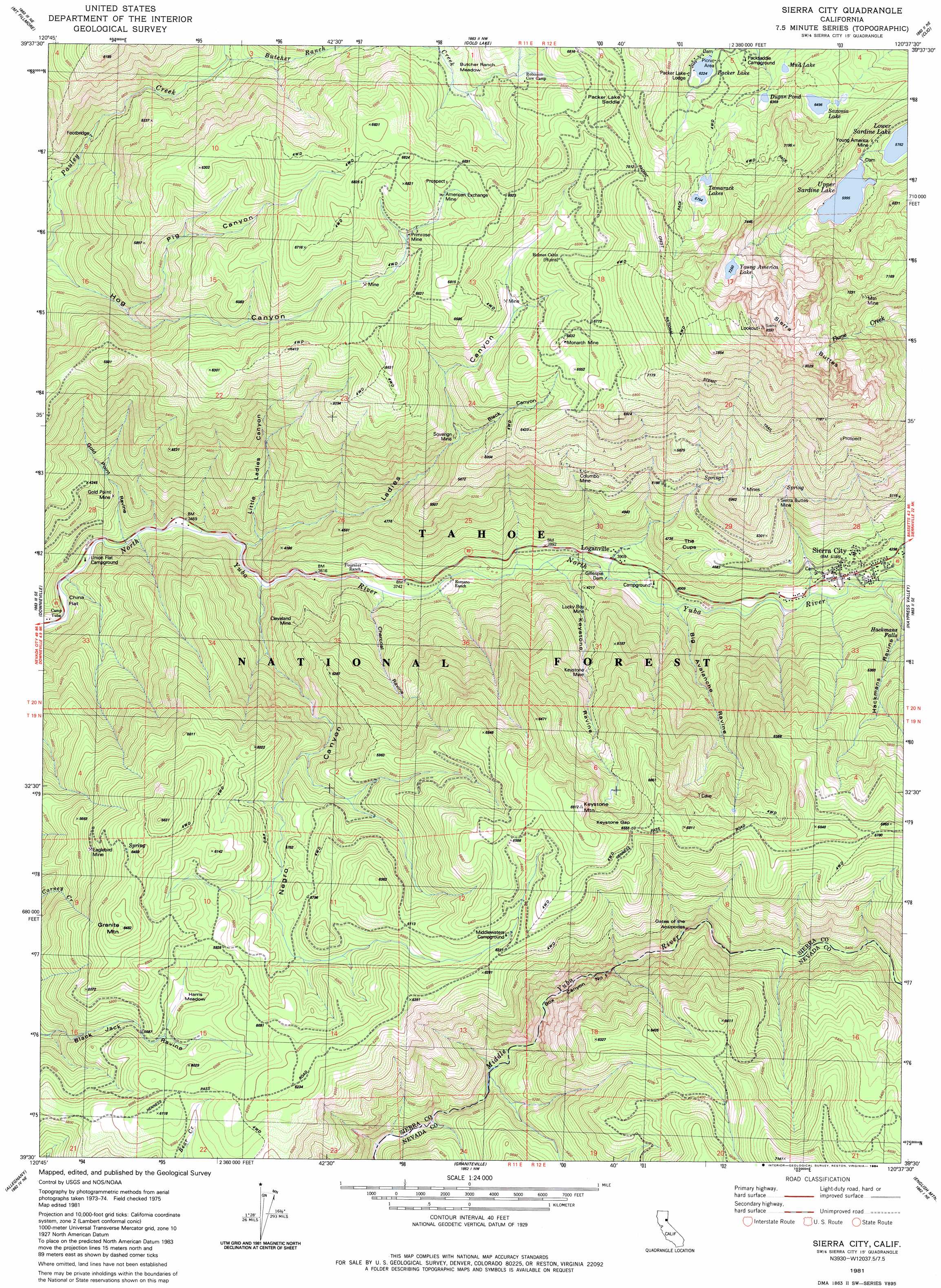
Sierra City Topo Map California
To zoom in, hover over the map of Sierra City
USGS Topo Quad 39120e6 - 1:24,000 scale
| Topo Map Name: | Sierra City |
| USGS Topo Quad ID: | 39120e6 |
| Print Size: | ca. 21 1/4" wide x 27" high |
| Southeast Coordinates: | 39.5° N latitude / 120.625° W longitude |
| Map Center Coordinates: | 39.5625° N latitude / 120.6875° W longitude |
| U.S. State: | CA |
| Filename: | o39120e6.jpg |
| Download Map JPG Image: | Sierra City topo map 1:24,000 scale |
| Map Type: | Topographic |
| Topo Series: | 7.5´ |
| Map Scale: | 1:24,000 |
| Source of Map Images: | United States Geological Survey (USGS) |
| Alternate Map Versions: |
Sierra City CA 1981, updated 1982 Download PDF Buy paper map Sierra City CA 1981, updated 1984 Download PDF Buy paper map Sierra City CA 2000, updated 2003 Download PDF Buy paper map Sierra City CA 2012 Download PDF Buy paper map Sierra City CA 2015 Download PDF Buy paper map |
| FStopo: | US Forest Service topo Sierra City is available: Download FStopo PDF Download FStopo TIF |
1:24,000 Topo Quads surrounding Sierra City
Onion Valley |
Blue Nose Mountain |
Johnsville |
Blairsden |
Portola |
La Porte |
Mount Fillmore |
Gold Lake |
Clio |
Calpine |
Goodyears Bar |
Downieville |
Sierra City |
Haypress Valley |
Sattley |
Pike |
Alleghany |
Graniteville |
English Mountain |
Webber Peak |
North Bloomfield |
Washington |
Blue Canyon |
Cisco Grove |
Soda Springs |
> Back to 39120e1 at 1:100,000 scale
> Back to 39120a1 at 1:250,000 scale
> Back to U.S. Topo Maps home
Sierra City topo map: Gazetteer
Sierra City: Dams
Packer Dam elevation 1899m 6230′Sierra City: Falls
Hackmans Falls elevation 1372m 4501′Sierra City: Flats
Butcher Ranch Meadows elevation 1903m 6243′China Flat elevation 1079m 3540′
Harris Meadow elevation 1775m 5823′
Sierra City: Gaps
Keystone Gap elevation 1998m 6555′Packer Lake Saddle elevation 2140m 7020′
Sierra City: Lakes
Dugan Pond elevation 1944m 6377′Mud Lake elevation 1936m 6351′
Packer Lake elevation 1898m 6227′
Saxonia Lake elevation 1981m 6499′
Tamarack Lakes elevation 2066m 6778′
Young America Lake elevation 2212m 7257′
Sierra City: Mines
American Exchange Mine elevation 2021m 6630′Banner Mine elevation 1773m 5816′
Buffalo Mine elevation 1895m 6217′
Burlington Mine elevation 1737m 5698′
Buttes Saddle Mine elevation 2046m 6712′
Cleveland Mine elevation 1283m 4209′
Columbo Mine elevation 1735m 5692′
Commodore Mine elevation 1755m 5757′
Dottie Q Mine elevation 1867m 6125′
Eaglebird Mine elevation 1794m 5885′
Gillespie Dam elevation 1198m 3930′
Gold Point Mine elevation 1105m 3625′
Keystone Mine elevation 1562m 5124′
Klondyke Mine elevation 1952m 6404′
Lucky Boy Mine elevation 1307m 4288′
Monarch Mine elevation 1993m 6538′
Mountain Mine elevation 2137m 7011′
Primrose Mine elevation 1973m 6473′
Roman Mine elevation 1817m 5961′
Sacred Mound Mine elevation 1846m 6056′
Saint Louis Mine elevation 1997m 6551′
Sierra Buttes Mine elevation 1613m 5291′
Sovereign Mine elevation 1672m 5485′
Young America Mine elevation 1805m 5921′
Sierra City: Populated Places
Loganville elevation 1213m 3979′Middle Waters (historical) elevation 1888m 6194′
Sierra City elevation 1273m 4176′
Sierra City: Post Offices
Sierra City Post Office elevation 1299m 4261′Sierra City: Reservoirs
Upper Sardine Lake elevation 1832m 6010′Sierra City: Streams
Butcher Ranch Creek elevation 1546m 5072′Macklin Creek elevation 1643m 5390′
Sierra City: Summits
Granite Mountain elevation 1955m 6414′Keystone Mountain elevation 2005m 6578′
Sierra Buttes elevation 2383m 7818′
Sierra City: Trails
Bee Ranch Trail elevation 1507m 4944′Butcher Ranch Trail elevation 1513m 4963′
Commodore Trail elevation 1702m 5583′
Lilliput Trail elevation 1721m 5646′
Sierra City: Valleys
Big Avalanche Ravine elevation 1211m 3973′Black Canyon elevation 1613m 5291′
Box Canyon Number One elevation 1498m 4914′
Charcoal Ravine elevation 1113m 3651′
Gold Point Ravine elevation 1051m 3448′
Gold Valley elevation 1551m 5088′
Hackmans Ravine elevation 1281m 4202′
Hog Canyon elevation 1495m 4904′
Keystone Ravine elevation 1171m 3841′
Ladies Canyon elevation 1081m 3546′
Little Ladies Canyon elevation 1115m 3658′
Negro Canyon elevation 1082m 3549′
Pig Canyon elevation 1490m 4888′
Sierra City digital topo map on disk
Buy this Sierra City topo map showing relief, roads, GPS coordinates and other geographical features, as a high-resolution digital map file on DVD: