Goodyears Bar Topo Map California
To zoom in, hover over the map of Goodyears Bar
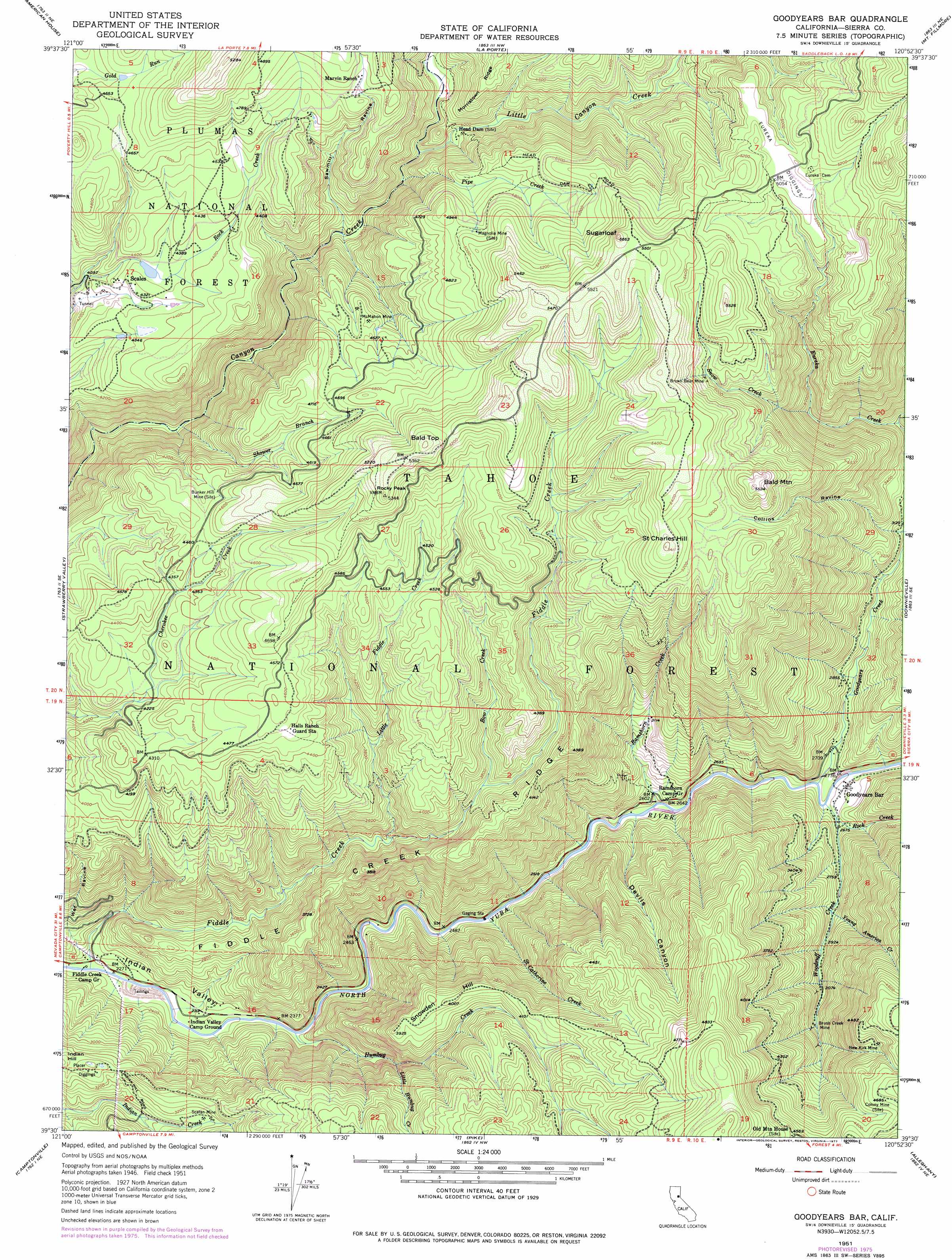
USGS Topo Quad 39120e8 - 1:24,000 scale
| Topo Map Name: | Goodyears Bar |
| USGS Topo Quad ID: | 39120e8 |
| Print Size: | ca. 21 1/4" wide x 27" high |
| Southeast Coordinates: | 39.5° N latitude / 120.875° W longitude |
| Map Center Coordinates: | 39.5625° N latitude / 120.9375° W longitude |
| U.S. State: | CA |
| Filename: | o39120e8.jpg |
| Download Map JPG Image: | Goodyears Bar topo map 1:24,000 scale |
| Map Type: | Topographic |
| Topo Series: | 7.5´ |
| Map Scale: | 1:24,000 |
| Source of Map Images: | United States Geological Survey (USGS) |
| Alternate Map Versions: |
Goodyears Bar CA 1951, updated 1953 Download PDF Buy paper map Goodyears Bar CA 1951, updated 1961 Download PDF Buy paper map Goodyears Bar CA 1951, updated 1972 Download PDF Buy paper map Goodyears Bar CA 1951, updated 1977 Download PDF Buy paper map Goodyears Bar CA 1951, updated 1995 Download PDF Buy paper map Goodyears Bar CA 2000, updated 2003 Download PDF Buy paper map Goodyears Bar CA 2012 Download PDF Buy paper map Goodyears Bar CA 2015 Download PDF Buy paper map |
| FStopo: | US Forest Service topo Goodyears Bar is available: Download FStopo PDF Download FStopo TIF |
1:24,000 Topo Quads surrounding Goodyears Bar
Haskins Valley |
Dogwood Peak |
Onion Valley |
Blue Nose Mountain |
Johnsville |
Cascade |
American House |
La Porte |
Mount Fillmore |
Gold Lake |
Clipper Mills |
Strawberry Valley |
Goodyears Bar |
Downieville |
Sierra City |
Challenge |
Camptonville |
Pike |
Alleghany |
Graniteville |
French Corral |
Nevada City |
North Bloomfield |
Washington |
Blue Canyon |
> Back to 39120e1 at 1:100,000 scale
> Back to 39120a1 at 1:250,000 scale
> Back to U.S. Topo Maps home
Goodyears Bar topo map: Gazetteer
Goodyears Bar: Bars
Saint Joe Bar elevation 779m 2555′Goodyears Bar: Mines
Bee Tree Borrow Pit elevation 1582m 5190′Brown Bear Mine elevation 1500m 4921′
Brush Creek Mine elevation 1025m 3362′
Eureka Diggings elevation 1543m 5062′
Golden Bear Mine elevation 1469m 4819′
McMahon Mine elevation 1367m 4484′
New Kirk Mine elevation 1327m 4353′
Scalan Mine elevation 958m 3143′
Goodyears Bar: Populated Places
Eureka (historical) elevation 1542m 5059′Goodyears Bar elevation 815m 2673′
Indian Hill (historical) elevation 1002m 3287′
McMahons (historical) elevation 1383m 4537′
Mount Pleasant elevation 1389m 4557′
Scales elevation 1321m 4333′
Goodyears Bar: Ridges
Fiddle Creek Ridge elevation 1240m 4068′Goodyears Bar: Streams
Bow Creek elevation 1114m 3654′Eureka Creek elevation 1031m 3382′
Fiddle Creek elevation 694m 2276′
Goodyears Creek elevation 803m 2634′
Humbug Creek elevation 718m 2355′
Little Canyon Creek elevation 1208m 3963′
Little Fiddle Creek elevation 987m 3238′
Little Humbug Creek elevation 917m 3008′
Pipe Creek elevation 1213m 3979′
Ramshorn Creek elevation 776m 2545′
Rock Creek elevation 814m 2670′
Saint Catherine Creek elevation 754m 2473′
Shower Branch elevation 1021m 3349′
Snow Creek elevation 1163m 3815′
Woodruff Creek elevation 805m 2641′
Young America Creek elevation 872m 2860′
Goodyears Bar: Summits
Bald Mountain elevation 1681m 5515′Bald Top elevation 1639m 5377′
Rocky Peak elevation 1595m 5232′
Saint Charles Hill elevation 1647m 5403′
Snowden Hill elevation 1221m 4005′
Sugarloaf elevation 1694m 5557′
Goodyears Bar: Trails
Fiddle Creek Trail elevation 893m 2929′Halls Ranch Trail elevation 1144m 3753′
Ramshorn Trail elevation 1221m 4005′
Goodyears Bar: Valleys
Collins Ravine elevation 935m 3067′Devils Canyon elevation 782m 2565′
Grant Ravine elevation 897m 2942′
Indian Valley elevation 695m 2280′
Sawmill Ravine elevation 1137m 3730′
Wet Ravine elevation 698m 2290′
Goodyears Bar digital topo map on disk
Buy this Goodyears Bar topo map showing relief, roads, GPS coordinates and other geographical features, as a high-resolution digital map file on DVD: