Clio Topo Map California
To zoom in, hover over the map of Clio
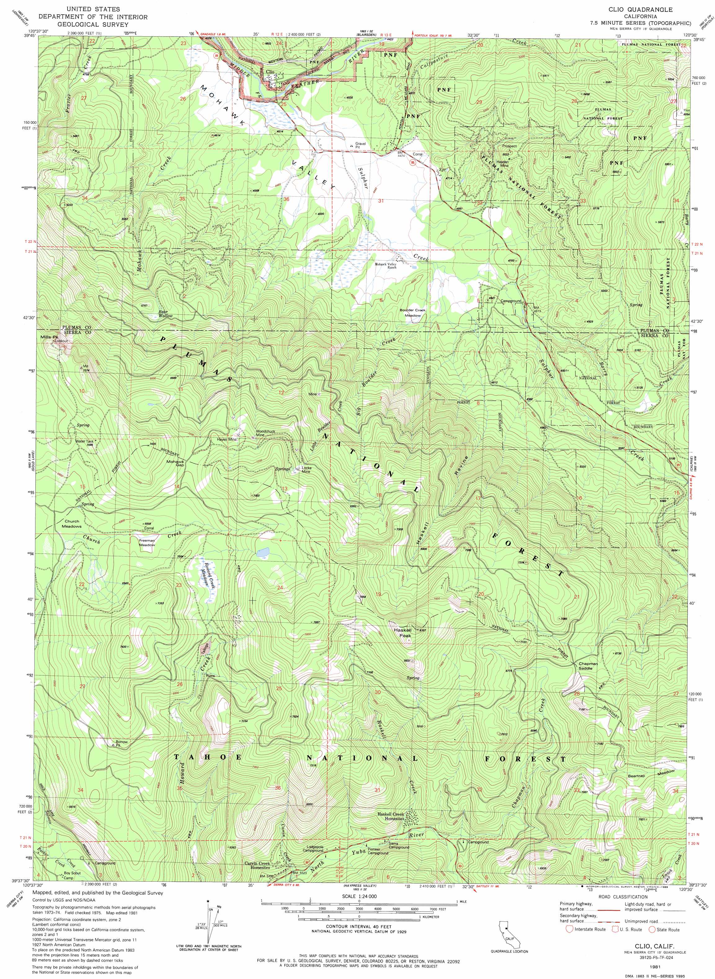
USGS Topo Quad 39120f5 - 1:24,000 scale
| Topo Map Name: | Clio |
| USGS Topo Quad ID: | 39120f5 |
| Print Size: | ca. 21 1/4" wide x 27" high |
| Southeast Coordinates: | 39.625° N latitude / 120.5° W longitude |
| Map Center Coordinates: | 39.6875° N latitude / 120.5625° W longitude |
| U.S. State: | CA |
| Filename: | o39120f5.jpg |
| Download Map JPG Image: | Clio topo map 1:24,000 scale |
| Map Type: | Topographic |
| Topo Series: | 7.5´ |
| Map Scale: | 1:24,000 |
| Source of Map Images: | United States Geological Survey (USGS) |
| Alternate Map Versions: |
Clio CA 1981, updated 1981 Download PDF Buy paper map Clio CA 1981, updated 1981 Download PDF Buy paper map Clio CA 1981, updated 1988 Download PDF Buy paper map Clio CA 1981, updated 1988 Download PDF Buy paper map Clio CA 2000, updated 2003 Download PDF Buy paper map Clio CA 2012 Download PDF Buy paper map Clio CA 2015 Download PDF Buy paper map |
| FStopo: | US Forest Service topo Clio is available: Download FStopo PDF Download FStopo TIF |
1:24,000 Topo Quads surrounding Clio
Spring Garden |
Mount Ingalls |
Grizzly Valley |
Crocker Mountain |
Dixie Mountain |
Blue Nose Mountain |
Johnsville |
Blairsden |
Portola |
Reconnaissance Peak |
Mount Fillmore |
Gold Lake |
Clio |
Calpine |
Antelope Valley |
Downieville |
Sierra City |
Haypress Valley |
Sattley |
Sierraville |
Alleghany |
Graniteville |
English Mountain |
Webber Peak |
Independence Lake |
> Back to 39120e1 at 1:100,000 scale
> Back to 39120a1 at 1:250,000 scale
> Back to U.S. Topo Maps home
Clio topo map: Gazetteer
Clio: Basins
Bear Wallow Basin elevation 1730m 5675′Clio: Flats
Beartrap Meadow elevation 2119m 6952′Boulder Creek Meadow elevation 1401m 4596′
Church Meadows elevation 2046m 6712′
Freeman Meadow elevation 2072m 6797′
Howard Creek Meadows elevation 2108m 6916′
Clio: Gaps
Chapman Saddle elevation 2041m 6696′Mohawk Gap elevation 2140m 7020′
Clio: Mines
Arctic Mine elevation 1995m 6545′Hayes Mine elevation 2113m 6932′
Locke Mine elevation 2132m 6994′
Placer Mine elevation 1766m 5793′
Woodchuck Mine elevation 2109m 6919′
Clio: Parks
Middle Fork Feather Wild and Scenic River elevation 1342m 4402′Clio: Populated Places
Carvin Creek Homesites elevation 1728m 5669′Clio elevation 1346m 4416′
Haskell Creek Homesites elevation 1780m 5839′
Valley Ranch elevation 1352m 4435′
Whitehawk elevation 1372m 4501′
Clio: Streams
Barry Creek elevation 1403m 4603′Big Boulder Creek elevation 1367m 4484′
Calfpasture Creek elevation 1351m 4432′
Carvin Creek elevation 1686m 5531′
Chapman Creek elevation 1749m 5738′
Haskell Creek elevation 1738m 5702′
Little Boulder Creek elevation 1707m 5600′
Mohawk Creek elevation 1338m 4389′
Packer Creek elevation 1751m 5744′
Sulphur Creek elevation 1340m 4396′
Willow Creek elevation 1338m 4389′
Clio: Summits
Haskell Peak elevation 2453m 8047′Millis Peak elevation 2152m 7060′
Schroeder Mountain elevation 2116m 6942′
Clio: Valleys
Haskell Ravine elevation 1413m 4635′Clio digital topo map on disk
Buy this Clio topo map showing relief, roads, GPS coordinates and other geographical features, as a high-resolution digital map file on DVD: