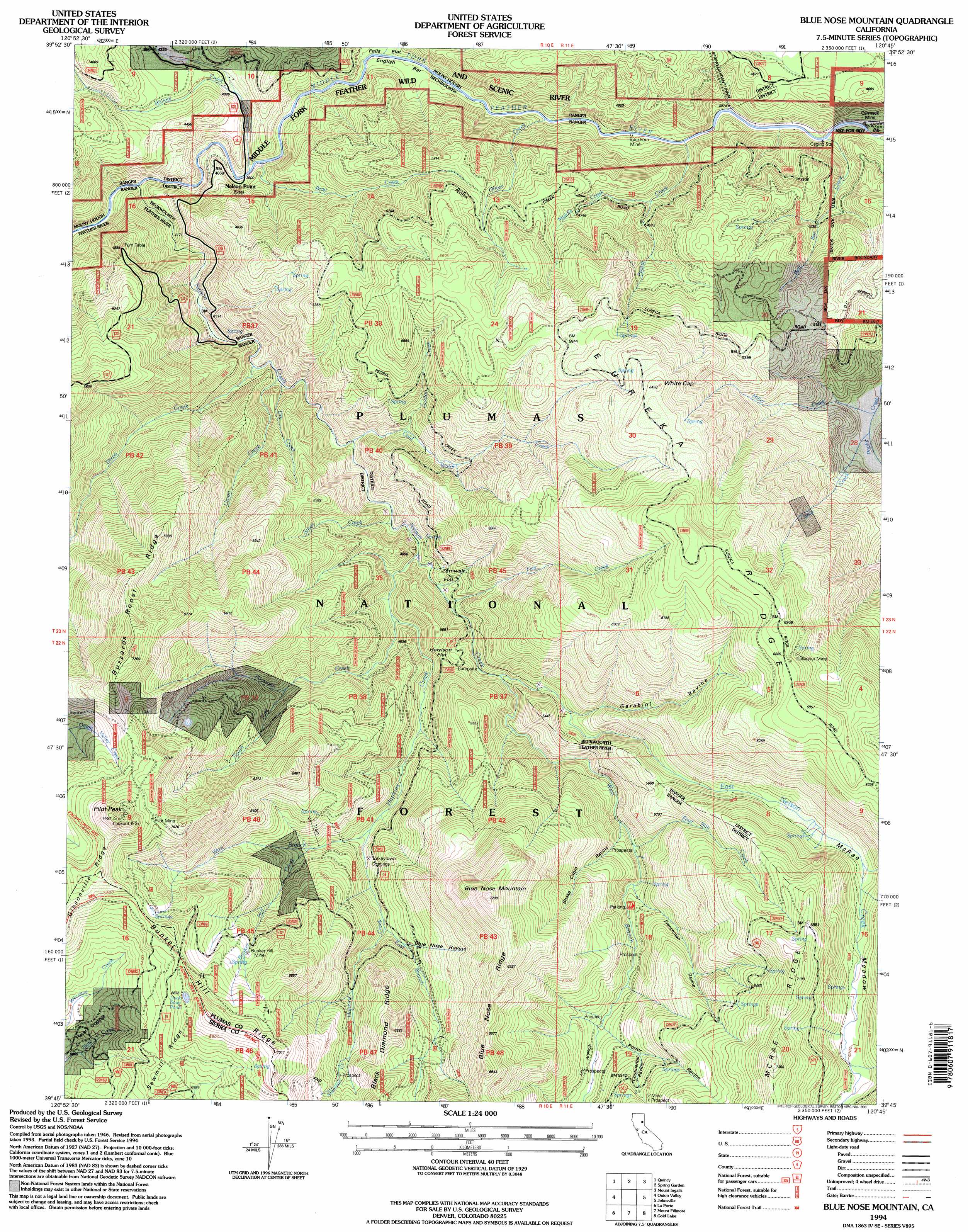
Blue Nose Mountain Topo Map California
To zoom in, hover over the map of Blue Nose Mountain
USGS Topo Quad 39120g7 - 1:24,000 scale
| Topo Map Name: | Blue Nose Mountain |
| USGS Topo Quad ID: | 39120g7 |
| Print Size: | ca. 21 1/4" wide x 27" high |
| Southeast Coordinates: | 39.75° N latitude / 120.75° W longitude |
| Map Center Coordinates: | 39.8125° N latitude / 120.8125° W longitude |
| U.S. State: | CA |
| Filename: | o39120g7.jpg |
| Download Map JPG Image: | Blue Nose Mountain topo map 1:24,000 scale |
| Map Type: | Topographic |
| Topo Series: | 7.5´ |
| Map Scale: | 1:24,000 |
| Source of Map Images: | United States Geological Survey (USGS) |
| Alternate Map Versions: |
Blue Nose Mtn CA 1951, updated 1953 Download PDF Buy paper map Blue Nose Mtn CA 1951, updated 1953 Download PDF Buy paper map Blue Nose Mtn CA 1951, updated 1963 Download PDF Buy paper map Blue Nose Mtn CA 1951, updated 1977 Download PDF Buy paper map Blue Nose Mtn CA 1951, updated 1977 Download PDF Buy paper map Blue Nose Mountain CA 1994, updated 1998 Download PDF Buy paper map Blue Nose Mountain CA 2012 Download PDF Buy paper map Blue Nose Mountain CA 2015 Download PDF Buy paper map |
| FStopo: | US Forest Service topo Blue Nose Mountain is available: Download FStopo PDF Download FStopo TIF |
1:24,000 Topo Quads surrounding Blue Nose Mountain
Twain |
Crescent Mills |
Taylorsville |
Genesee Valley |
Babcock Peak |
Meadow Valley |
Quincy |
Spring Garden |
Mount Ingalls |
Grizzly Valley |
Dogwood Peak |
Onion Valley |
Blue Nose Mountain |
Johnsville |
Blairsden |
American House |
La Porte |
Mount Fillmore |
Gold Lake |
Clio |
Strawberry Valley |
Goodyears Bar |
Downieville |
Sierra City |
Haypress Valley |
> Back to 39120e1 at 1:100,000 scale
> Back to 39120a1 at 1:250,000 scale
> Back to U.S. Topo Maps home
Blue Nose Mountain topo map: Gazetteer
Blue Nose Mountain: Bars
Bill Bar elevation 1237m 4058′English Bar elevation 1195m 3920′
Blue Nose Mountain: Flats
Fells Flat elevation 1199m 3933′Harrison Flat elevation 1473m 4832′
McRae Meadow elevation 1882m 6174′
Zumwalt Flat elevation 1401m 4596′
Blue Nose Mountain: Lakes
Duck Soup Pond elevation 2034m 6673′Blue Nose Mountain: Mines
Buckhorn Mine elevation 1219m 3999′Bunker Hill Mine elevation 1905m 6250′
Carmack Mine elevation 1252m 4107′
Gallagher Mine elevation 2023m 6637′
Pilot Mine elevation 2080m 6824′
Turkeytown Diggings elevation 1560m 5118′
Blue Nose Mountain: Populated Places
Bells Bar (historical) elevation 1240m 4068′English Bar (historical) elevation 1208m 3963′
Blue Nose Mountain: Ridges
Blue Nose Ridge elevation 2029m 6656′Bunker Hill Ridge elevation 2040m 6692′
Buzzard Roost Ridge elevation 2114m 6935′
Eureka Ridge elevation 2084m 6837′
Blue Nose Mountain: Streams
Bell Bar Creek elevation 1261m 4137′Bray Creek elevation 1183m 3881′
Bunker Hill Creek elevation 1575m 5167′
Camp Creek elevation 1362m 4468′
Cold Water Creek elevation 1290m 4232′
Dixon Creek elevation 1225m 4019′
Dry Creek elevation 1248m 4094′
East Branch Hopkins Creek elevation 1587m 5206′
East Nelson Creek elevation 1424m 4671′
Fells Creek elevation 1194m 3917′
Fish Creek elevation 1354m 4442′
Four Bits Creek elevation 1545m 5068′
Golden Creek elevation 1377m 4517′
Hopkins Creek elevation 1351m 4432′
Middle Creek elevation 1343m 4406′
Miller Creek elevation 1357m 4452′
Nelson Creek elevation 1167m 3828′
Oliver Creek elevation 1206m 3956′
Peoria Creek elevation 1218m 3996′
Poorman Creek elevation 1364m 4475′
Poplar Creek elevation 1239m 4064′
Sherman Creek elevation 1765m 5790′
Silver Creek elevation 1326m 4350′
South Fork Poorman Creek elevation 1545m 5068′
Union Creek elevation 1240m 4068′
West Branch Hopkins Creek elevation 1510m 4954′
West Branch Nelson Creek elevation 1424m 4671′
Willow Creek elevation 1198m 3930′
Blue Nose Mountain: Summits
Blue Nose Mountain elevation 2217m 7273′Pilot Peak elevation 2271m 7450′
Turn Table elevation 1492m 4895′
White Cap elevation 1965m 6446′
Blue Nose Mountain: Valleys
Blue Nose Ravine elevation 1649m 5410′Continental Ravine elevation 1758m 5767′
Frenchman Ravine elevation 1612m 5288′
Garabini Ravine elevation 1571m 5154′
Porter Ravine elevation 1679m 5508′
Shake Cabin Ravine elevation 1580m 5183′
Blue Nose Mountain digital topo map on disk
Buy this Blue Nose Mountain topo map showing relief, roads, GPS coordinates and other geographical features, as a high-resolution digital map file on DVD: