Quincy Topo Map California
To zoom in, hover over the map of Quincy
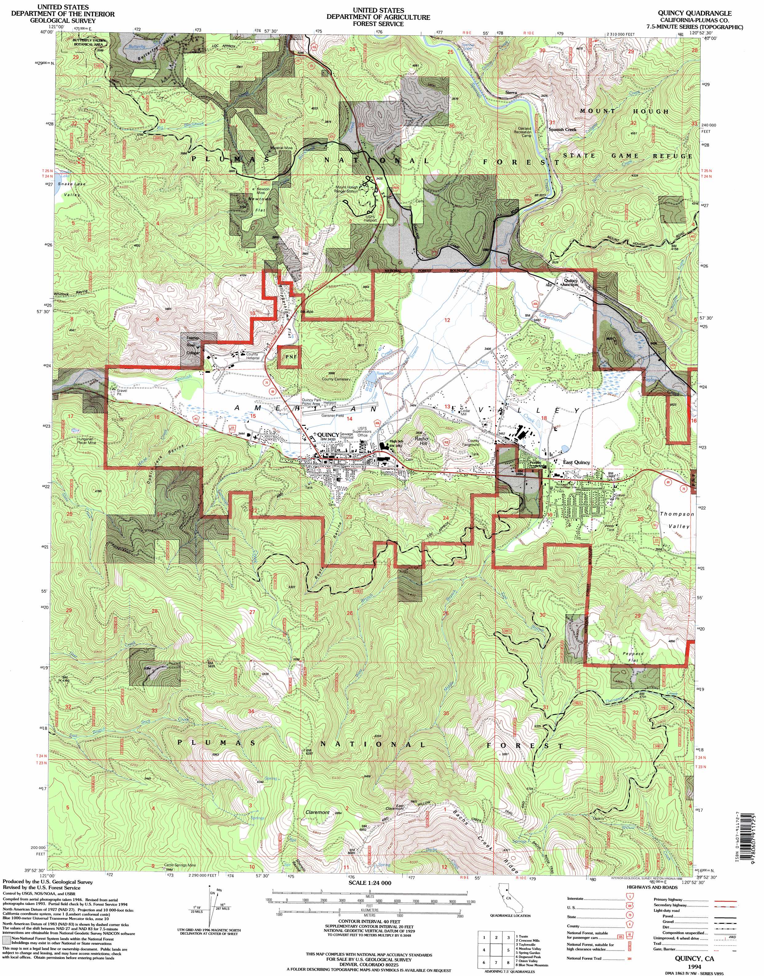
USGS Topo Quad 39120h8 - 1:24,000 scale
| Topo Map Name: | Quincy |
| USGS Topo Quad ID: | 39120h8 |
| Print Size: | ca. 21 1/4" wide x 27" high |
| Southeast Coordinates: | 39.875° N latitude / 120.875° W longitude |
| Map Center Coordinates: | 39.9375° N latitude / 120.9375° W longitude |
| U.S. State: | CA |
| Filename: | o39120h8.jpg |
| Download Map JPG Image: | Quincy topo map 1:24,000 scale |
| Map Type: | Topographic |
| Topo Series: | 7.5´ |
| Map Scale: | 1:24,000 |
| Source of Map Images: | United States Geological Survey (USGS) |
| Alternate Map Versions: |
Quincy CA 1950, updated 1958 Download PDF Buy paper map Quincy CA 1950, updated 1965 Download PDF Buy paper map Quincy CA 1950, updated 1972 Download PDF Buy paper map Quincy CA 1950, updated 1977 Download PDF Buy paper map Quincy CA 1950, updated 1986 Download PDF Buy paper map Quincy CA 1951 Download PDF Buy paper map Quincy CA 1994, updated 1998 Download PDF Buy paper map Quincy CA 2012 Download PDF Buy paper map Quincy CA 2015 Download PDF Buy paper map |
| FStopo: | US Forest Service topo Quincy is available: Download FStopo PDF Download FStopo TIF |
1:24,000 Topo Quads surrounding Quincy
Almanor |
Canyondam |
Greenville |
Moonlight Peak |
Kettle Rock |
Caribou |
Twain |
Crescent Mills |
Taylorsville |
Genesee Valley |
Bucks Lake |
Meadow Valley |
Quincy |
Spring Garden |
Mount Ingalls |
Haskins Valley |
Dogwood Peak |
Onion Valley |
Blue Nose Mountain |
Johnsville |
Cascade |
American House |
La Porte |
Mount Fillmore |
Gold Lake |
> Back to 39120e1 at 1:100,000 scale
> Back to 39120a1 at 1:250,000 scale
> Back to U.S. Topo Maps home
Quincy topo map: Gazetteer
Quincy: Airports
Gansner Field elevation 1040m 3412′Plumas District Hospital Heliport elevation 1048m 3438′
Quincy Helitack Base Heliport elevation 1056m 3464′
Quincy: Flats
American Valley elevation 1041m 3415′Elizabethtown Flat elevation 1068m 3503′
Newtown Flat elevation 1098m 3602′
Peppard Flat elevation 1446m 4744′
Quincy: Forests
Feather River Experimental Forest elevation 1589m 5213′Quincy: Mines
Cattle Spring Mine elevation 1705m 5593′Hungarian Placer Mine elevation 1294m 4245′
Imperial Mine elevation 1185m 3887′
Newtown Mine elevation 1105m 3625′
Quincy: Parks
Gansner Park elevation 1042m 3418′Pioneer Park elevation 1061m 3480′
Plumas County Fairgrounds elevation 1052m 3451′
Quincy: Populated Places
Cedar Mill elevation 1043m 3421′East Quincy elevation 1064m 3490′
Quincy elevation 1046m 3431′
Quincy Junction elevation 1073m 3520′
Silongkoyo (historical) elevation 1047m 3435′
Quincy: Ridges
Bachs Creek Ridge elevation 1928m 6325′Quincy: Streams
Berry Creek elevation 1057m 3467′Chandler Creek elevation 1044m 3425′
Clear Stream elevation 1035m 3395′
East Branch Mill Creek elevation 1152m 3779′
Gansner Creek elevation 1054m 3458′
Gilson Creek elevation 1013m 3323′
Greenhorn Creek elevation 1031m 3382′
Little Blackhawk Creek elevation 993m 3257′
Middle Branch Mill Creek elevation 1151m 3776′
Mill Creek elevation 1034m 3392′
Taylor Creek elevation 1050m 3444′
Tollgate Creek elevation 1024m 3359′
West Branch Mill Creek elevation 1153m 3782′
White Creek elevation 1070m 3510′
Quincy: Summits
Claremont elevation 2106m 6909′East Claremont elevation 2091m 6860′
Radio Hill elevation 1199m 3933′
Quincy: Trails
Bachs Ridge Trail elevation 1817m 5961′Claremont Trail elevation 1920m 6299′
Willow Creek Trail elevation 2002m 6568′
Quincy: Valleys
Boyle Ravine elevation 1098m 3602′Dublin Jack Ravine elevation 1063m 3487′
Quincy digital topo map on disk
Buy this Quincy topo map showing relief, roads, GPS coordinates and other geographical features, as a high-resolution digital map file on DVD: