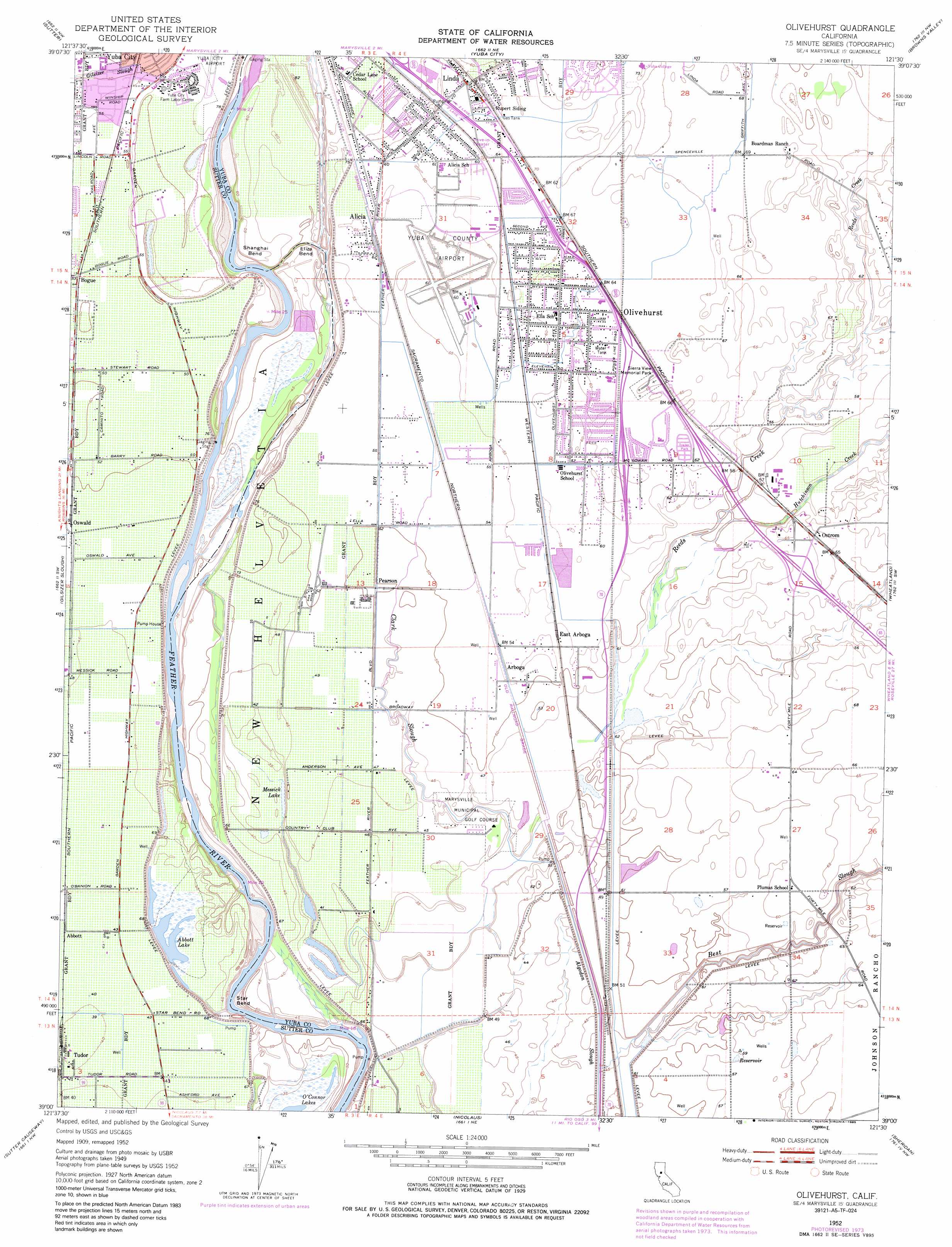
Olivehurst Topo Map California
To zoom in, hover over the map of Olivehurst
USGS Topo Quad 39121a5 - 1:24,000 scale
| Topo Map Name: | Olivehurst |
| USGS Topo Quad ID: | 39121a5 |
| Print Size: | ca. 21 1/4" wide x 27" high |
| Southeast Coordinates: | 39° N latitude / 121.5° W longitude |
| Map Center Coordinates: | 39.0625° N latitude / 121.5625° W longitude |
| U.S. State: | CA |
| Filename: | o39121a5.jpg |
| Download Map JPG Image: | Olivehurst topo map 1:24,000 scale |
| Map Type: | Topographic |
| Topo Series: | 7.5´ |
| Map Scale: | 1:24,000 |
| Source of Map Images: | United States Geological Survey (USGS) |
| Alternate Map Versions: |
Olivehurst CA 1952, updated 1953 Download PDF Buy paper map Olivehurst CA 1952, updated 1966 Download PDF Buy paper map Olivehurst CA 1952, updated 1974 Download PDF Buy paper map Olivehurst CA 1952, updated 1974 Download PDF Buy paper map Olivehurst CA 1952, updated 1985 Download PDF Buy paper map Olivehurst CA 2012 Download PDF Buy paper map Olivehurst CA 2015 Download PDF Buy paper map |
1:24,000 Topo Quads surrounding Olivehurst
Pennington |
Gridley |
Honcut |
Loma Rica |
Oregon House |
Sutter Buttes |
Sutter |
Yuba City |
Browns Valley |
Smartville |
Tisdale Weir |
Gilsizer Slough |
Olivehurst |
Wheatland |
Camp Far West |
Kirkville |
Sutter Causeway |
Nicolaus |
Sheridan |
Lincoln |
Eldorado Bend |
Knights Landing |
Verona |
Pleasant Grove |
Roseville |
> Back to 39121a1 at 1:100,000 scale
> Back to 39120a1 at 1:250,000 scale
> Back to U.S. Topo Maps home
Olivehurst topo map: Gazetteer
Olivehurst: Airports
Yuba County Airport elevation 19m 62′Olivehurst: Bends
Eliza Bend elevation 17m 55′Shanghai Bend elevation 14m 45′
Star Bend elevation 10m 32′
Olivehurst: Guts
Algodon Slough elevation 16m 52′Clark Slough elevation 14m 45′
Olivehurst: Lakes
Abbott Lake elevation 13m 42′Messick Lake elevation 13m 42′
Plumas Lake (historical) elevation 13m 42′
Olivehurst: Parks
Blackburn Talley Park elevation 16m 52′Hillcrest Park elevation 17m 55′
Shanghai Bend Park elevation 15m 49′
Olivehurst: Populated Places
Alicia elevation 18m 59′Arboga elevation 17m 55′
Bogue elevation 16m 52′
Casa Mia Mobile Home Park elevation 22m 72′
East Arboga elevation 17m 55′
Olivehurst elevation 20m 65′
Ostrom elevation 21m 68′
Peach Mobile Estates elevation 19m 62′
Pearson elevation 16m 52′
Plumas Lake elevation 14m 45′
The Garden Mobile Home Park elevation 19m 62′
Tudor elevation 13m 42′
Villa Seville Mobile Home Park elevation 20m 65′
Vinboy Trailer Park elevation 22m 72′
West Linda elevation 19m 62′
Yuba (historical) elevation 19m 62′
Yuba Mobile Home Park elevation 19m 62′
Olivehurst: Streams
Best Slough elevation 14m 45′Hutchinson Creek elevation 16m 52′
Reeds Creek elevation 16m 52′
Olivehurst digital topo map on disk
Buy this Olivehurst topo map showing relief, roads, GPS coordinates and other geographical features, as a high-resolution digital map file on DVD: