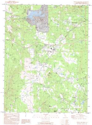
Rough And Ready Topo Map California
To zoom in, hover over the map of Rough And Ready
USGS Topo Quad 39121b2 - 1:24,000 scale
| Topo Map Name: | Rough And Ready |
| USGS Topo Quad ID: | 39121b2 |
| Print Size: | ca. 21 1/4" wide x 27" high |
| Southeast Coordinates: | 39.125° N latitude / 121.125° W longitude |
| Map Center Coordinates: | 39.1875° N latitude / 121.1875° W longitude |
| U.S. State: | CA |
| Filename: | o39121b2.jpg |
| Download Map JPG Image: | Rough And Ready topo map 1:24,000 scale |
| Map Type: | Topographic |
| Topo Series: | 7.5´ |
| Map Scale: | 1:24,000 |
| Source of Map Images: | United States Geological Survey (USGS) |
| Alternate Map Versions: |
Rough And Ready CA 1949, updated 1955 Download PDF Buy paper map Rough And Ready CA 1949, updated 1973 Download PDF Buy paper map Rough And Ready CA 1949, updated 1977 Download PDF Buy paper map Rough And Ready CA 1950 Download PDF Buy paper map Rough And Ready CA 1995, updated 1995 Download PDF Buy paper map Rough And Ready CA 1998, updated 2002 Download PDF Buy paper map Rough And Ready CA 2012 Download PDF Buy paper map Rough And Ready CA 2015 Download PDF Buy paper map |
1:24,000 Topo Quads surrounding Rough And Ready
> Back to 39121a1 at 1:100,000 scale
> Back to 39120a1 at 1:250,000 scale
> Back to U.S. Topo Maps home
Rough And Ready topo map: Gazetteer
Rough And Ready: Airports
Limberlost Ranch Airport elevation 494m 1620′Rough And Ready: Basins
Penn Valley elevation 422m 1384′Rough And Ready: Beaches
Pine Island Beach elevation 371m 1217′Rough And Ready: Canals
Bald Hill Ditch elevation 506m 1660′Clear Creek Lateral elevation 493m 1617′
Lower Ditch elevation 647m 2122′
Pet Hill Ditch elevation 515m 1689′
Rex Ditch elevation 537m 1761′
Riffle Box Ditch elevation 422m 1384′
Smith-Gordon Ditch elevation 533m 1748′
Tarr Ditch elevation 508m 1666′
Tunnel Ditch elevation 564m 1850′
Rough And Ready: Capes
Peacock Point elevation 368m 1207′Rough And Ready: Dams
Anthony House 1300-002 Dam elevation 353m 1158′Swan 1301 Dam elevation 478m 1568′
Rough And Ready: Mines
Black Bear Mine elevation 482m 1581′Kentucky Ridge Mine elevation 653m 2142′
Mistletoe Mine elevation 552m 1811′
Niagara Mine elevation 605m 1984′
Rough And Ready: Parks
Bugler Cove Park elevation 370m 1213′Forest Circle Park elevation 377m 1236′
Meadow Park elevation 369m 1210′
Miners Gulch Park elevation 368m 1207′
Vista Park elevation 369m 1210′
Western Gateway Regional Park elevation 425m 1394′
Rough And Ready: Populated Places
Casey Corner elevation 432m 1417′Lake Wildwood elevation 466m 1528′
Penn Valley elevation 427m 1400′
Rough and Ready elevation 576m 1889′
Rough And Ready: Reservoirs
Lake Wildwood elevation 353m 1158′Rex Reservoir elevation 550m 1804′
Rough and Ready Reservoir elevation 640m 2099′
Rough And Ready: Ridges
Horton Ridge elevation 513m 1683′Kentucky Ridge elevation 705m 2312′
Rough And Ready: Streams
Clear Creek elevation 426m 1397′Grub Creek elevation 436m 1430′
Squirrel Creek elevation 245m 803′
Rough And Ready: Summits
George Washington Hill elevation 499m 1637′Haney Mountain elevation 544m 1784′
Iron Mountain elevation 566m 1856′
Pilot Peak elevation 663m 2175′
Vandervere Mountain elevation 559m 1833′
Rough And Ready: Valleys
Blue Ravine elevation 537m 1761′Osceola Ravine elevation 542m 1778′
Rough And Ready digital topo map on disk
Buy this Rough And Ready topo map showing relief, roads, GPS coordinates and other geographical features, as a high-resolution digital map file on DVD:


