Yuba City Topo Map California
To zoom in, hover over the map of Yuba City
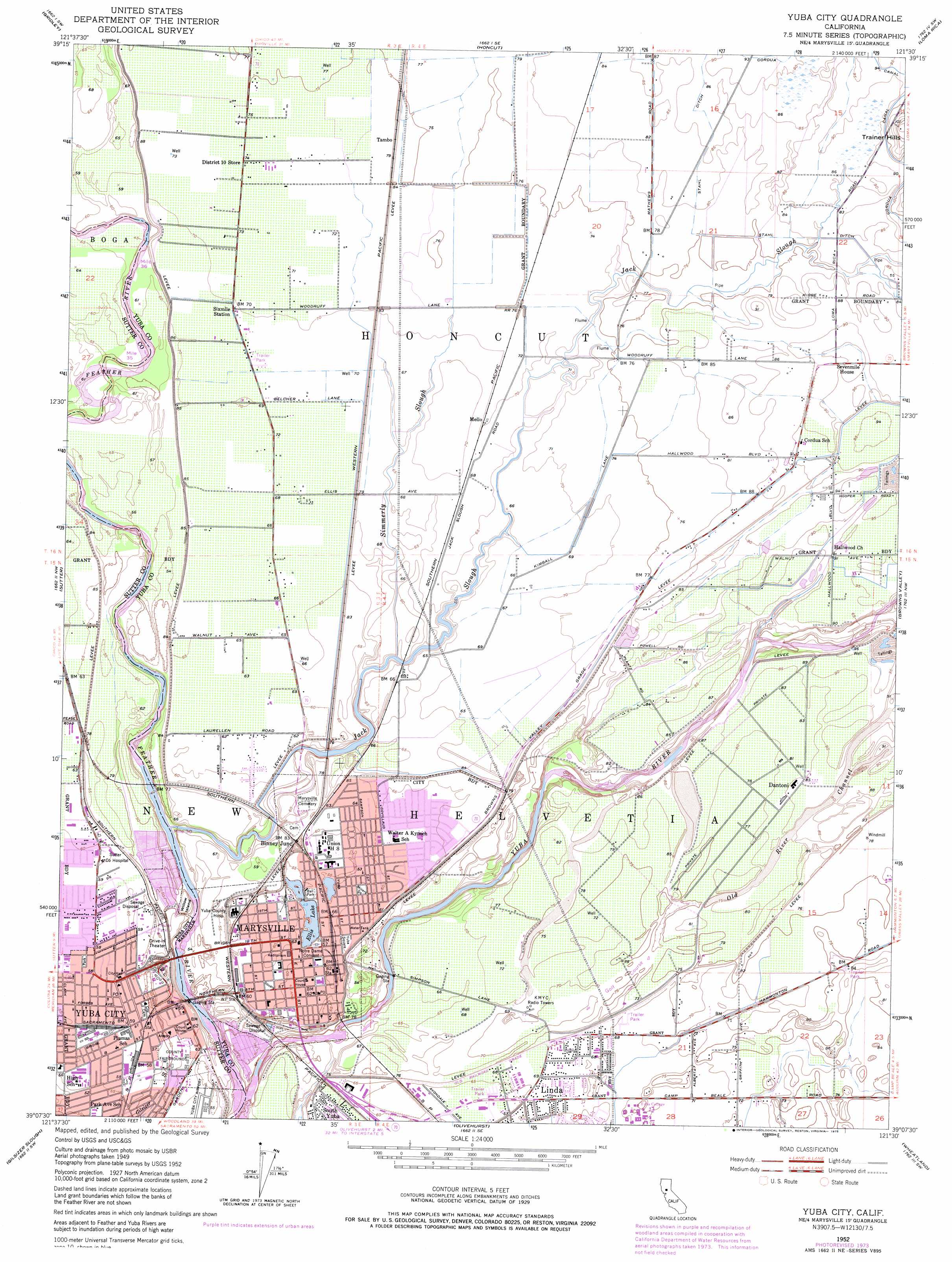
USGS Topo Quad 39121b5 - 1:24,000 scale
| Topo Map Name: | Yuba City |
| USGS Topo Quad ID: | 39121b5 |
| Print Size: | ca. 21 1/4" wide x 27" high |
| Southeast Coordinates: | 39.125° N latitude / 121.5° W longitude |
| Map Center Coordinates: | 39.1875° N latitude / 121.5625° W longitude |
| U.S. State: | CA |
| Filename: | o39121b5.jpg |
| Download Map JPG Image: | Yuba City topo map 1:24,000 scale |
| Map Type: | Topographic |
| Topo Series: | 7.5´ |
| Map Scale: | 1:24,000 |
| Source of Map Images: | United States Geological Survey (USGS) |
| Alternate Map Versions: |
Yuba City CA 1952, updated 1954 Download PDF Buy paper map Yuba City CA 1952, updated 1966 Download PDF Buy paper map Yuba City CA 1952, updated 1975 Download PDF Buy paper map Yuba City CA 1952, updated 1975 Download PDF Buy paper map Yuba City CA 1952, updated 1975 Download PDF Buy paper map Yuba City CA 2012 Download PDF Buy paper map Yuba City CA 2015 Download PDF Buy paper map |
1:24,000 Topo Quads surrounding Yuba City
West Of Biggs |
Biggs |
Palermo |
Bangor |
Rackerby |
Pennington |
Gridley |
Honcut |
Loma Rica |
Oregon House |
Sutter Buttes |
Sutter |
Yuba City |
Browns Valley |
Smartville |
Tisdale Weir |
Gilsizer Slough |
Olivehurst |
Wheatland |
Camp Far West |
Kirkville |
Sutter Causeway |
Nicolaus |
Sheridan |
Lincoln |
> Back to 39121a1 at 1:100,000 scale
> Back to 39120a1 at 1:250,000 scale
> Back to U.S. Topo Maps home
Yuba City topo map: Gazetteer
Yuba City: Airports
Cheim Airport (historical) elevation 20m 65′Sutter County Airport elevation 16m 52′
Yuba City: Bridges
Twin Cities Memorial Bridge elevation 15m 49′Yuba City: Canals
Cordua Canal elevation 30m 98′Stahl Ditch elevation 27m 88′
Yuba City: Guts
Old River Channel elevation 25m 82′Yuba City: Islands
Willow Island elevation 18m 59′Yuba City: Lakes
Eastpark Lake elevation 17m 55′Ellis Lake elevation 16m 52′
Yuba City: Parks
Alta Park elevation 19m 62′Basin Park elevation 20m 65′
Bryant Field elevation 17m 55′
Ellis Lake Park elevation 16m 52′
Gauche Park elevation 17m 55′
Maple Park elevation 18m 59′
Market Square elevation 17m 55′
Memorial Stadium elevation 20m 65′
Miners Square elevation 19m 62′
Morley Park elevation 17m 55′
Napoleon Square elevation 19m 62′
Plaza Park elevation 22m 72′
River Front Park elevation 17m 55′
S J Field Park elevation 19m 62′
Southside Park elevation 15m 49′
Triplett Park elevation 20m 65′
Veterans Park elevation 19m 62′
Washington Square elevation 19m 62′
Yuba Square elevation 20m 65′
Yuba-Sutter Fairgrounds elevation 16m 52′
Yuba City: Populated Places
Alpine Village Mobile Home Estates elevation 21m 68′Binney Junction elevation 19m 62′
Castlewood Mobile Home Park elevation 23m 75′
Country Side Mobile Home Park elevation 27m 88′
Dantoni elevation 26m 85′
Linda elevation 21m 68′
Marysville elevation 19m 62′
Mello elevation 22m 72′
Oliver (historical) elevation 16m 52′
South Yuba elevation 20m 65′
Tambo elevation 24m 78′
Thunderbird Mobile Home Park elevation 20m 65′
Yuba City elevation 18m 59′
Yupu (historical) elevation 18m 59′
Yuba City: Post Offices
Marysville Post Office elevation 19m 62′Yuba City Post Office elevation 18m 59′
Yuba City: Streams
Jack Slough elevation 14m 45′Simmerly Slough elevation 17m 55′
Yuba River elevation 15m 49′
Yuba City digital topo map on disk
Buy this Yuba City topo map showing relief, roads, GPS coordinates and other geographical features, as a high-resolution digital map file on DVD: