Gridley Topo Map California
To zoom in, hover over the map of Gridley
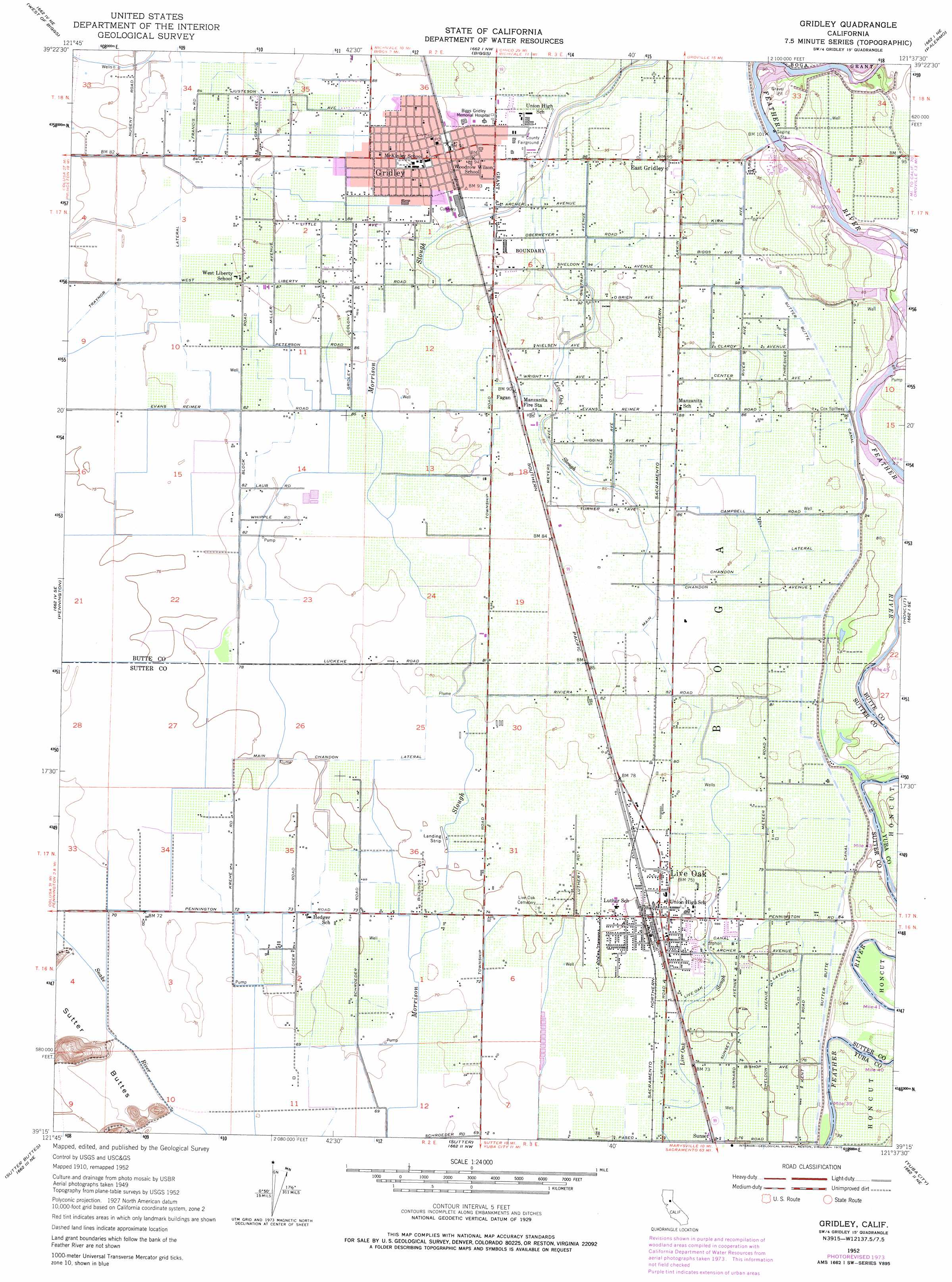
USGS Topo Quad 39121c6 - 1:24,000 scale
| Topo Map Name: | Gridley |
| USGS Topo Quad ID: | 39121c6 |
| Print Size: | ca. 21 1/4" wide x 27" high |
| Southeast Coordinates: | 39.25° N latitude / 121.625° W longitude |
| Map Center Coordinates: | 39.3125° N latitude / 121.6875° W longitude |
| U.S. State: | CA |
| Filename: | o39121c6.jpg |
| Download Map JPG Image: | Gridley topo map 1:24,000 scale |
| Map Type: | Topographic |
| Topo Series: | 7.5´ |
| Map Scale: | 1:24,000 |
| Source of Map Images: | United States Geological Survey (USGS) |
| Alternate Map Versions: |
Gridley CA 1952, updated 1953 Download PDF Buy paper map Gridley CA 1952, updated 1967 Download PDF Buy paper map Gridley CA 1952, updated 1974 Download PDF Buy paper map Gridley CA 1952, updated 1975 Download PDF Buy paper map Gridley CA 2012 Download PDF Buy paper map Gridley CA 2015 Download PDF Buy paper map |
1:24,000 Topo Quads surrounding Gridley
Llano Seco |
Nelson |
Shippee |
Oroville |
Oroville Dam |
Butte City |
West Of Biggs |
Biggs |
Palermo |
Bangor |
Sanborn Slough |
Pennington |
Gridley |
Honcut |
Loma Rica |
Meridian |
Sutter Buttes |
Sutter |
Yuba City |
Browns Valley |
Grimes |
Tisdale Weir |
Gilsizer Slough |
Olivehurst |
Wheatland |
> Back to 39121a1 at 1:100,000 scale
> Back to 39120a1 at 1:250,000 scale
> Back to U.S. Topo Maps home
Gridley topo map: Gazetteer
Gridley: Airports
Bowles Airport elevation 24m 78′Gridley: Canals
Cox Spillway elevation 24m 78′Live Oak Canal elevation 24m 78′
Main Chandon Lateral elevation 24m 78′
Sunset Avenue Lateral elevation 23m 75′
Sutter Butte Canal elevation 24m 78′
Traynor Lateral elevation 26m 85′
Gridley: Parks
Butte County Fairgrounds elevation 29m 95′Live Oak Memorial Park elevation 24m 78′
Manuel Vierra Park elevation 29m 95′
Nick Daddow Plaza elevation 29m 95′
Gridley: Populated Places
Bihlman (historical) elevation 23m 75′Chandon (historical) elevation 27m 88′
East Gridley elevation 30m 98′
Fagan elevation 28m 91′
Gridley elevation 29m 95′
Gridley Colony Number One (historical) elevation 28m 91′
Gridley Colony Number Two (historical) elevation 29m 95′
Live Oak elevation 24m 78′
Riviera (historical) elevation 25m 82′
Sunset elevation 23m 75′
Gridley: Post Offices
Gridley Post Office elevation 28m 91′Live Oak Post Office elevation 24m 78′
Gridley digital topo map on disk
Buy this Gridley topo map showing relief, roads, GPS coordinates and other geographical features, as a high-resolution digital map file on DVD: