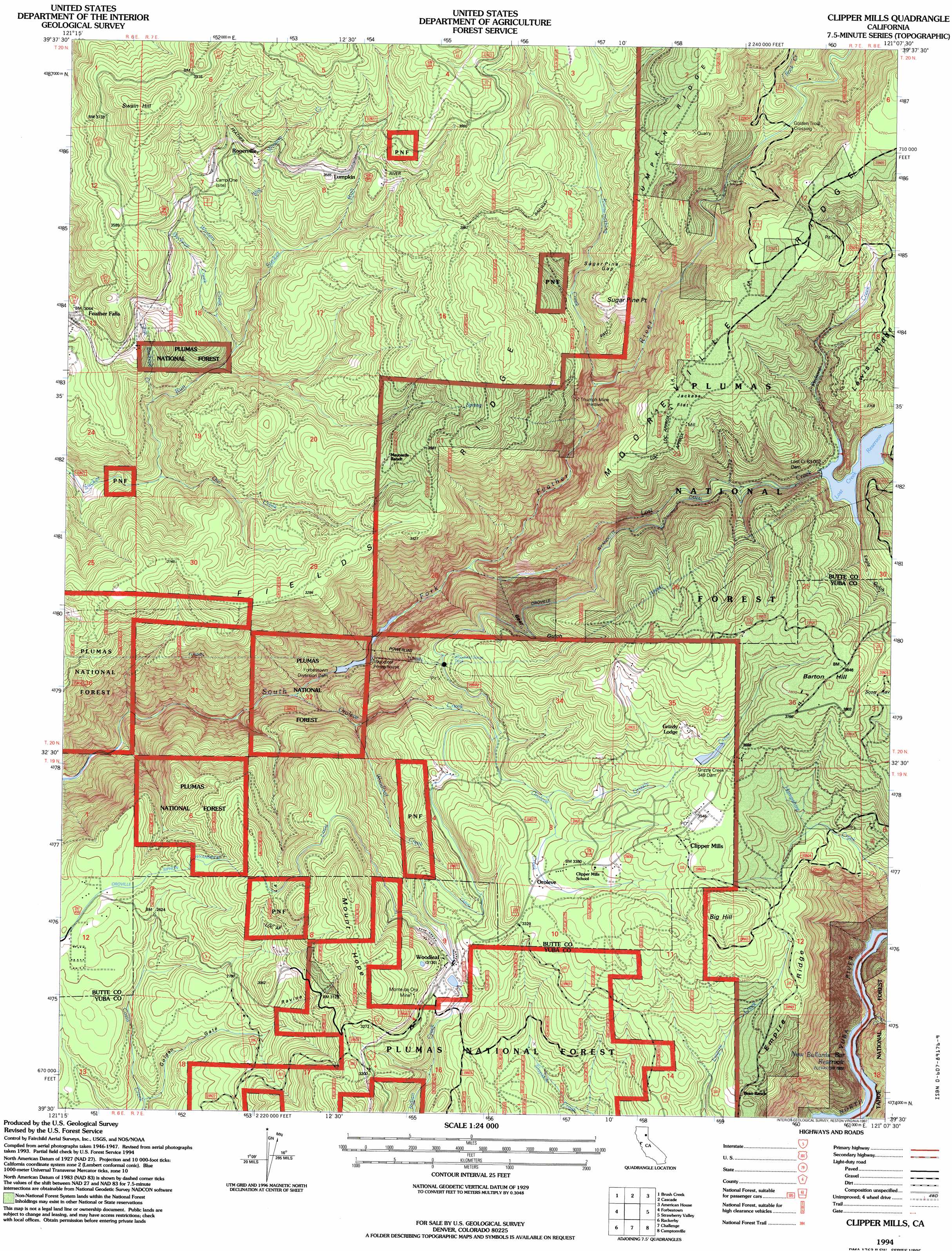
Clipper Mills Topo Map California
To zoom in, hover over the map of Clipper Mills
USGS Topo Quad 39121e2 - 1:24,000 scale
| Topo Map Name: | Clipper Mills |
| USGS Topo Quad ID: | 39121e2 |
| Print Size: | ca. 21 1/4" wide x 27" high |
| Southeast Coordinates: | 39.5° N latitude / 121.125° W longitude |
| Map Center Coordinates: | 39.5625° N latitude / 121.1875° W longitude |
| U.S. State: | CA |
| Filename: | o39121e2.jpg |
| Download Map JPG Image: | Clipper Mills topo map 1:24,000 scale |
| Map Type: | Topographic |
| Topo Series: | 7.5´ |
| Map Scale: | 1:24,000 |
| Source of Map Images: | United States Geological Survey (USGS) |
| Alternate Map Versions: |
Clipper Mills CA 1948, updated 1959 Download PDF Buy paper map Clipper Mills CA 1948, updated 1959 Download PDF Buy paper map Clipper Mills CA 1948, updated 1978 Download PDF Buy paper map Clipper Mills CA 1948, updated 1978 Download PDF Buy paper map Clipper Mills CA 1948, updated 1987 Download PDF Buy paper map Clipper Mills CA 1950 Download PDF Buy paper map Clipper Mills CA 1950 Download PDF Buy paper map Clipper Mills CA 1994, updated 1997 Download PDF Buy paper map Clipper Mills CA 2012 Download PDF Buy paper map Clipper Mills CA 2015 Download PDF Buy paper map |
| FStopo: | US Forest Service topo Clipper Mills is available: Download FStopo PDF Download FStopo TIF |
1:24,000 Topo Quads surrounding Clipper Mills
Pulga |
Soapstone Hill |
Haskins Valley |
Dogwood Peak |
Onion Valley |
Berry Creek |
Brush Creek |
Cascade |
American House |
La Porte |
Oroville Dam |
Forbestown |
Clipper Mills |
Strawberry Valley |
Goodyears Bar |
Bangor |
Rackerby |
Challenge |
Camptonville |
Pike |
Loma Rica |
Oregon House |
French Corral |
Nevada City |
North Bloomfield |
> Back to 39121e1 at 1:100,000 scale
> Back to 39120a1 at 1:250,000 scale
> Back to U.S. Topo Maps home
Clipper Mills topo map: Gazetteer
Clipper Mills: Capes
Sugar Pine Point elevation 1164m 3818′Clipper Mills: Crossings
Golden Trout Crossing elevation 973m 3192′Clipper Mills: Dams
Forbestown Diversion 63-007 Dam elevation 544m 1784′Forbestown Diversion Dam elevation 544m 1784′
Grizzly Creek 349 Dam elevation 1068m 3503′
Lost Creek 63-002 Dam elevation 1001m 3284′
Clipper Mills: Flats
Jackass Flat elevation 1153m 3782′Clipper Mills: Gaps
Sugar Pine Gap elevation 1141m 3743′Clipper Mills: Mines
Monte de Oro Mine elevation 1000m 3280′Triumph Mine elevation 921m 3021′
Clipper Mills: Populated Places
Clipper Mills elevation 1082m 3549′Lasslys (historical) elevation 822m 2696′
Lumpkin elevation 1093m 3585′
Mount Hope House (historical) elevation 902m 2959′
Oroleve elevation 1017m 3336′
Rogerville elevation 1050m 3444′
Woodleaf elevation 955m 3133′
Clipper Mills: Reservoirs
Lost Creek Reservoir elevation 1002m 3287′Clipper Mills: Ridges
Empire Ridge elevation 1037m 3402′Fields Ridge elevation 1026m 3366′
Mooreville Ridge elevation 1195m 3920′
Clipper Mills: Streams
Big Winters Creek elevation 931m 3054′Buckeye Creek elevation 880m 2887′
Grizzly Creek elevation 985m 3231′
Know-nothing Creek elevation 865m 2837′
Little Buckeye Creek elevation 798m 2618′
Lost Creek elevation 606m 1988′
Lost Creek elevation 582m 1909′
Oroleve Creek elevation 502m 1646′
Owl Creek elevation 759m 2490′
Pinkard Creek elevation 1002m 3287′
Rock Creek elevation 990m 3248′
Strawberry Valley Creek elevation 1003m 3290′
Winters Creek elevation 838m 2749′
Woodleaf Creek elevation 704m 2309′
Clipper Mills: Summits
Barton Hill elevation 1176m 3858′Big Hill elevation 1145m 3756′
Mount Hope elevation 1075m 3526′
Swain Hill elevation 1248m 4094′
Clipper Mills: Valleys
Bear Gulch elevation 666m 2185′Eagle Gulch elevation 1002m 3287′
Golden Gate Ravine elevation 725m 2378′
Clipper Mills digital topo map on disk
Buy this Clipper Mills topo map showing relief, roads, GPS coordinates and other geographical features, as a high-resolution digital map file on DVD: