American House Topo Map California
To zoom in, hover over the map of American House
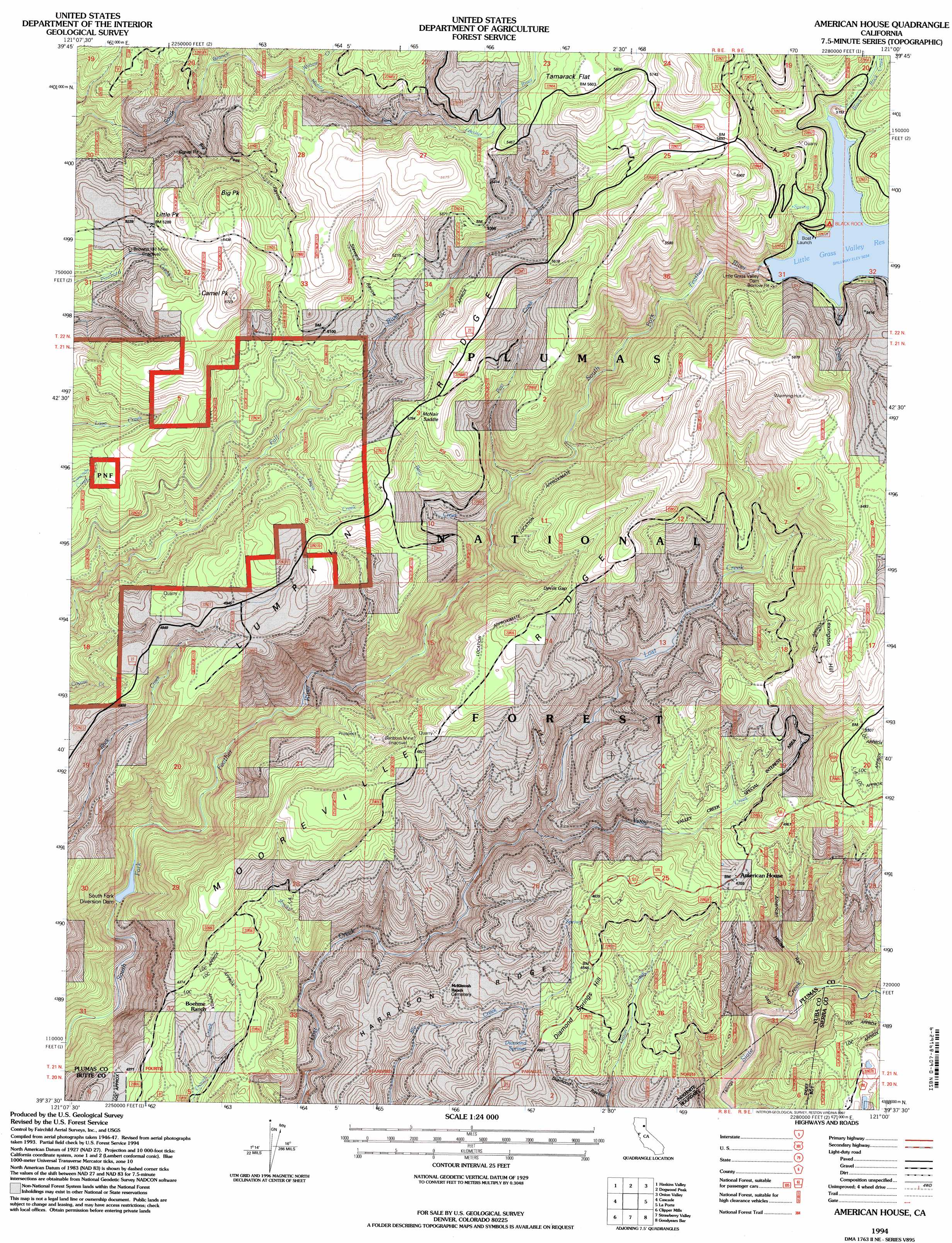
USGS Topo Quad 39121f1 - 1:24,000 scale
| Topo Map Name: | American House |
| USGS Topo Quad ID: | 39121f1 |
| Print Size: | ca. 21 1/4" wide x 27" high |
| Southeast Coordinates: | 39.625° N latitude / 121° W longitude |
| Map Center Coordinates: | 39.6875° N latitude / 121.0625° W longitude |
| U.S. State: | CA |
| Filename: | o39121f1.jpg |
| Download Map JPG Image: | American House topo map 1:24,000 scale |
| Map Type: | Topographic |
| Topo Series: | 7.5´ |
| Map Scale: | 1:24,000 |
| Source of Map Images: | United States Geological Survey (USGS) |
| Alternate Map Versions: |
American House CA 1948, updated 1956 Download PDF Buy paper map American House CA 1948, updated 1978 Download PDF Buy paper map American House CA 1948, updated 1978 Download PDF Buy paper map American House CA 1950 Download PDF Buy paper map American House CA 1950 Download PDF Buy paper map American House CA 1994, updated 1997 Download PDF Buy paper map American House CA 2012 Download PDF Buy paper map American House CA 2015 Download PDF Buy paper map |
| FStopo: | US Forest Service topo American House is available: Download FStopo PDF Download FStopo TIF |
1:24,000 Topo Quads surrounding American House
Storrie |
Bucks Lake |
Meadow Valley |
Quincy |
Spring Garden |
Soapstone Hill |
Haskins Valley |
Dogwood Peak |
Onion Valley |
Blue Nose Mountain |
Brush Creek |
Cascade |
American House |
La Porte |
Mount Fillmore |
Forbestown |
Clipper Mills |
Strawberry Valley |
Goodyears Bar |
Downieville |
Rackerby |
Challenge |
Camptonville |
Pike |
Alleghany |
> Back to 39121e1 at 1:100,000 scale
> Back to 39120a1 at 1:250,000 scale
> Back to U.S. Topo Maps home
American House topo map: Gazetteer
American House: Areas
Valley Creek Special Interest Area elevation 1418m 4652′American House: Dams
Little Grass Valley 63-003 Dam elevation 1621m 5318′South Fork Diversion 63-004 Dam elevation 1064m 3490′
American House: Flats
Tamarack Flat elevation 1706m 5597′American House: Gaps
Devils Gap elevation 1532m 5026′McNair Saddle elevation 1598m 5242′
American House: Mines
Browns Hill Mine elevation 1535m 5036′American House: Reservoirs
Little Grass Valley Reservoir elevation 1535m 5036′American House: Ridges
Harrison Ridge elevation 1344m 4409′Lumpkin Ridge elevation 1612m 5288′
Mooreville Ridge elevation 1555m 5101′
American House: Springs
Diamond Springs elevation 1374m 4507′American House: Streams
Bear Creek elevation 1280m 4199′Black Rock Creek elevation 1535m 5036′
Davis Creek elevation 1397m 4583′
Ice Creek elevation 1535m 5036′
Post Creek elevation 1303m 4274′
Rocky Creek elevation 1161m 3809′
Valley Creek elevation 1250m 4101′
Willow Creek elevation 1503m 4931′
American House: Summits
Big Peak elevation 1686m 5531′Camel Peak elevation 1737m 5698′
Diamond Springs Hill elevation 1398m 4586′
Lexington Hill elevation 1757m 5764′
Little Peak elevation 1662m 5452′
American House: Valleys
American House Ravine elevation 1156m 3792′Big Peak Ravine elevation 1418m 4652′
Diamond Ravine elevation 1216m 3989′
Little Grass Valley elevation 1524m 5000′
Steward Ravine elevation 1498m 4914′
American House digital topo map on disk
Buy this American House topo map showing relief, roads, GPS coordinates and other geographical features, as a high-resolution digital map file on DVD: