Chico Topo Map California
To zoom in, hover over the map of Chico
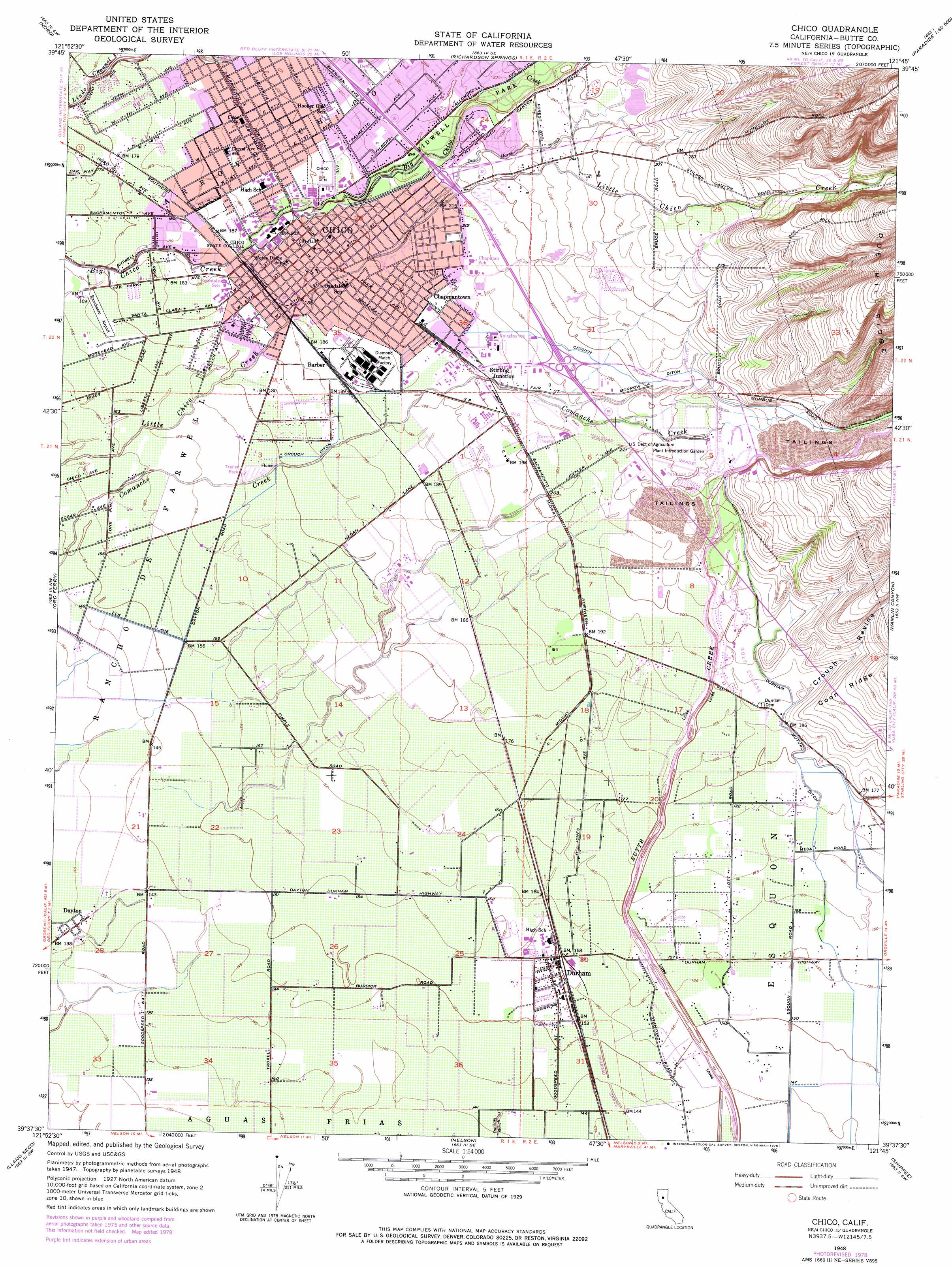
USGS Topo Quad 39121f7 - 1:24,000 scale
| Topo Map Name: | Chico |
| USGS Topo Quad ID: | 39121f7 |
| Print Size: | ca. 21 1/4" wide x 27" high |
| Southeast Coordinates: | 39.625° N latitude / 121.75° W longitude |
| Map Center Coordinates: | 39.6875° N latitude / 121.8125° W longitude |
| U.S. State: | CA |
| Filename: | o39121f7.jpg |
| Download Map JPG Image: | Chico topo map 1:24,000 scale |
| Map Type: | Topographic |
| Topo Series: | 7.5´ |
| Map Scale: | 1:24,000 |
| Source of Map Images: | United States Geological Survey (USGS) |
| Alternate Map Versions: |
Chico CA 1948, updated 1955 Download PDF Buy paper map Chico CA 1948, updated 1971 Download PDF Buy paper map Chico CA 1948, updated 1971 Download PDF Buy paper map Chico CA 1948, updated 1978 Download PDF Buy paper map Chico CA 1948, updated 1978 Download PDF Buy paper map Chico CA 1950 Download PDF Buy paper map Chico CA 2012 Download PDF Buy paper map Chico CA 2015 Download PDF Buy paper map |
1:24,000 Topo Quads surrounding Chico
Vina |
Richardson Springs Nw |
Campbell Mound |
Cohasset |
Stirling City |
Foster Island |
Nord |
Richardson Springs |
Paradise West |
Paradise East |
Hamilton City |
Ord Ferry |
Chico |
Hamlin Canyon |
Cherokee |
Glenn |
Llano Seco |
Nelson |
Shippee |
Oroville |
Princeton |
Butte City |
West Of Biggs |
Biggs |
Palermo |
> Back to 39121e1 at 1:100,000 scale
> Back to 39120a1 at 1:250,000 scale
> Back to U.S. Topo Maps home
Chico topo map: Gazetteer
Chico: Airports
Butte Creek Hog Ranch Airport elevation 62m 203′Enloe Hospital Heliport elevation 60m 196′
Ranchaero Airport elevation 54m 177′
Chico: Canals
Butte Creek Diversion Channel elevation 82m 269′Crough Ditch elevation 69m 226′
Durham Mutual Ditch elevation 54m 177′
Chico: Parks
Bidwell Mansion State Historic Park elevation 60m 196′Bidwell Park elevation 69m 226′
Depot Park elevation 57m 187′
Oak Way Park elevation 53m 173′
Silver Dollar Fairgrounds elevation 63m 206′
Twentieth Street Park elevation 66m 216′
Chico: Populated Places
Barber elevation 58m 190′Chapmantown elevation 63m 206′
Chico elevation 60m 196′
Dayton elevation 43m 141′
Durham elevation 49m 160′
Eskini (historical) elevation 48m 157′
Michopdo (historical) elevation 57m 187′
Roble elevation 53m 173′
Stirling Junction elevation 62m 203′
Chico: Post Offices
Chico Post Office elevation 60m 196′Chico: Streams
Dead Horse Slough elevation 63m 206′Chico: Valleys
Crouch Ravine elevation 57m 187′Chico digital topo map on disk
Buy this Chico topo map showing relief, roads, GPS coordinates and other geographical features, as a high-resolution digital map file on DVD: