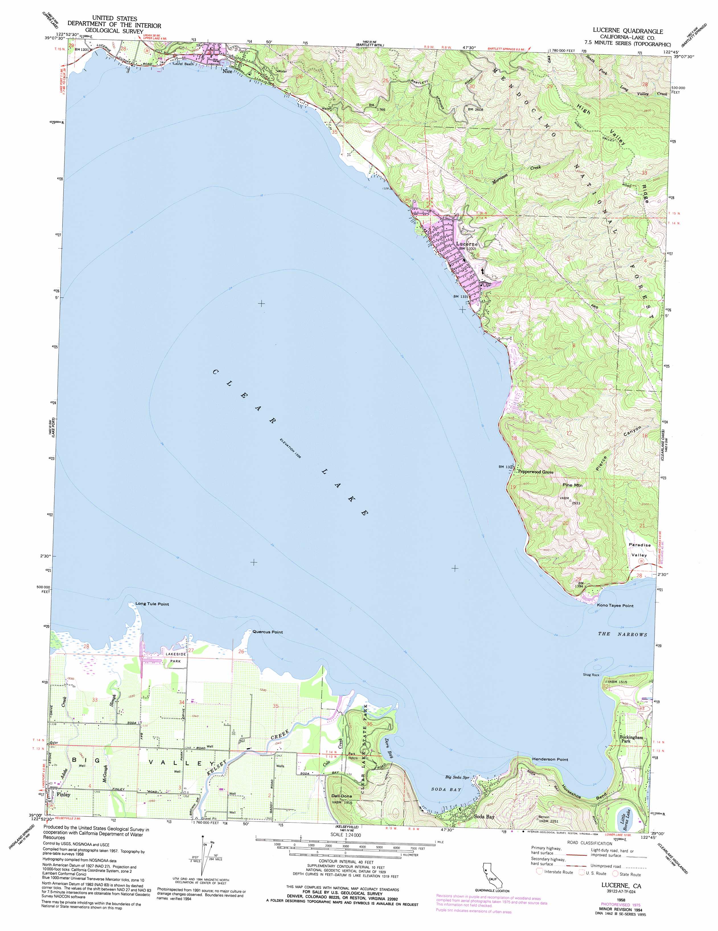
Lucerne Topo Map California
To zoom in, hover over the map of Lucerne
USGS Topo Quad 39122a7 - 1:24,000 scale
| Topo Map Name: | Lucerne |
| USGS Topo Quad ID: | 39122a7 |
| Print Size: | ca. 21 1/4" wide x 27" high |
| Southeast Coordinates: | 39° N latitude / 122.75° W longitude |
| Map Center Coordinates: | 39.0625° N latitude / 122.8125° W longitude |
| U.S. State: | CA |
| Filename: | o39122a7.jpg |
| Download Map JPG Image: | Lucerne topo map 1:24,000 scale |
| Map Type: | Topographic |
| Topo Series: | 7.5´ |
| Map Scale: | 1:24,000 |
| Source of Map Images: | United States Geological Survey (USGS) |
| Alternate Map Versions: |
Lucerne CA 1958, updated 1961 Download PDF Buy paper map Lucerne CA 1958, updated 1967 Download PDF Buy paper map Lucerne CA 1958, updated 1978 Download PDF Buy paper map Lucerne CA 1958, updated 1994 Download PDF Buy paper map Lucerne CA 1977, updated 1980 Download PDF Buy paper map Lucerne CA 1996, updated 2001 Download PDF Buy paper map Lucerne CA 2012 Download PDF Buy paper map Lucerne CA 2015 Download PDF Buy paper map |
| FStopo: | US Forest Service topo Lucerne is available: Download FStopo PDF Download FStopo TIF |
1:24,000 Topo Quads surrounding Lucerne
Potter Valley |
Elk Mountain |
Potato Hill |
Fouts Springs |
Gilmore Peak |
Cow Mountain |
Upper Lake |
Bartlett Mountain |
Bartlett Springs |
Hough Springs |
Purdys Gardens |
Lakeport |
Lucerne |
Clearlake Oaks |
Benmore Canyon |
Hopland |
Highland Springs |
Kelseyville |
Clearlake |
Lower Lake |
Cloverdale |
Asti |
The Geysers |
Whispering Pines |
Middletown |
> Back to 39122a1 at 1:100,000 scale
> Back to 39122a1 at 1:250,000 scale
> Back to U.S. Topo Maps home
Lucerne topo map: Gazetteer
Lucerne: Airports
Ferndale Resort Seaplane Base elevation 407m 1335′Lucerne: Basins
Paradise Valley elevation 413m 1354′Lucerne: Bays
Dorn Bay elevation 405m 1328′Soda Bay elevation 405m 1328′
Lucerne: Beaches
Laurel Beach elevation 405m 1328′Lucerne: Bends
Horseshoe Bend elevation 434m 1423′Lucerne: Capes
Henderson Point elevation 446m 1463′Kono Tayee Point elevation 405m 1328′
Long Tule Point elevation 405m 1328′
Quercus Point elevation 405m 1328′
Lucerne: Channels
The Narrows elevation 405m 1328′Lucerne: Guts
Shirley Slough elevation 405m 1328′Lucerne: Islands
Shag Rock elevation 405m 1328′Lucerne: Lakes
Clear Lake elevation 405m 1328′Little Borax Lake elevation 403m 1322′
Lucerne: Parks
Clear Lake State Park elevation 406m 1332′Keeling Park elevation 406m 1332′
Lakeside Park elevation 406m 1332′
Lucerne: Populated Places
Buckingham Park elevation 431m 1414′Lucerne elevation 405m 1328′
Nice elevation 415m 1361′
Pepperwood Grove elevation 405m 1328′
Soda Bay elevation 426m 1397′
Lucerne: Post Offices
Nice Post Office elevation 417m 1368′Lucerne: Ridges
High Valley Ridge elevation 1059m 3474′Lucerne: Springs
Big Soda Spring elevation 405m 1328′Lucerne: Streams
Cole Creek elevation 406m 1332′Kelsey Creek elevation 405m 1328′
McGaugh Slough elevation 405m 1328′
Morrison Creek elevation 405m 1328′
Old Kelsey Creek elevation 405m 1328′
Lucerne: Summits
Dali-Dona elevation 577m 1893′Pine Mountain elevation 771m 2529′
Lucerne: Trails
Dorn Nature Trail elevation 422m 1384′Indian Nature Trail elevation 451m 1479′
Lucerne: Valleys
Pierce Canyon elevation 424m 1391′Lucerne digital topo map on disk
Buy this Lucerne topo map showing relief, roads, GPS coordinates and other geographical features, as a high-resolution digital map file on DVD: