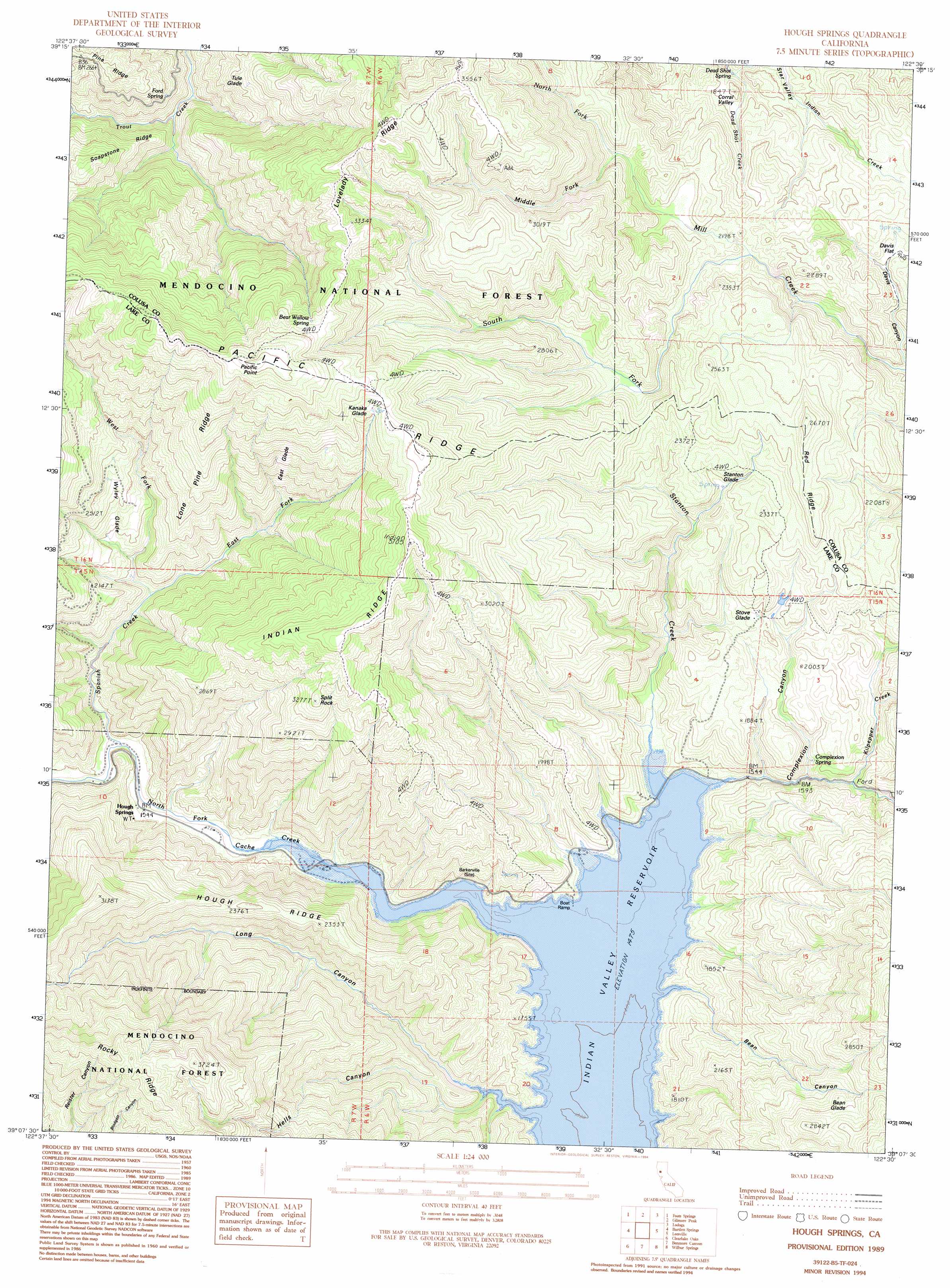
Hough Springs Topo Map California
To zoom in, hover over the map of Hough Springs
USGS Topo Quad 39122b5 - 1:24,000 scale
| Topo Map Name: | Hough Springs |
| USGS Topo Quad ID: | 39122b5 |
| Print Size: | ca. 21 1/4" wide x 27" high |
| Southeast Coordinates: | 39.125° N latitude / 122.5° W longitude |
| Map Center Coordinates: | 39.1875° N latitude / 122.5625° W longitude |
| U.S. State: | CA |
| Filename: | o39122b5.jpg |
| Download Map JPG Image: | Hough Springs topo map 1:24,000 scale |
| Map Type: | Topographic |
| Topo Series: | 7.5´ |
| Map Scale: | 1:24,000 |
| Source of Map Images: | United States Geological Survey (USGS) |
| Alternate Map Versions: |
Hough Springs CA 1989, updated 1989 Download PDF Buy paper map Hough Springs CA 1989, updated 1994 Download PDF Buy paper map Hough Springs CA 1996, updated 2001 Download PDF Buy paper map Hough Springs CA 2012 Download PDF Buy paper map Hough Springs CA 2015 Download PDF Buy paper map |
| FStopo: | US Forest Service topo Hough Springs is available: Download FStopo PDF Download FStopo TIF |
1:24,000 Topo Quads surrounding Hough Springs
Crockett Peak |
Saint John Mountain |
Stonyford |
Rail Canyon |
Logan Ridge |
Potato Hill |
Fouts Springs |
Gilmore Peak |
Lodoga |
Sites |
Bartlett Mountain |
Bartlett Springs |
Hough Springs |
Leesville |
Manor Slough |
Lucerne |
Clearlake Oaks |
Benmore Canyon |
Wilbur Springs |
Salt Canyon |
Kelseyville |
Clearlake |
Lower Lake |
Wilson Valley |
Glascock Mountain |
> Back to 39122a1 at 1:100,000 scale
> Back to 39122a1 at 1:250,000 scale
> Back to U.S. Topo Maps home
Hough Springs topo map: Gazetteer
Hough Springs: Basins
Corral Valley elevation 576m 1889′Hough Springs: Flats
Bean Glade elevation 777m 2549′Davis Flat elevation 557m 1827′
East Glade elevation 868m 2847′
Kanaka Glade elevation 966m 3169′
Stanton Glade elevation 694m 2276′
Stove Glade elevation 600m 1968′
Tule Glade elevation 767m 2516′
Wyley Glade elevation 587m 1925′
Hough Springs: Populated Places
Barkerville (historical) elevation 452m 1482′Hough Springs elevation 468m 1535′
Hough Springs: Ridges
Hough Ridge elevation 735m 2411′Indian Ridge elevation 1037m 3402′
Lone Pine Ridge elevation 881m 2890′
Lovelady Ridge elevation 1016m 3333′
Red Ridge elevation 794m 2604′
Hough Springs: Springs
Bear Wallow Spring elevation 1059m 3474′Complexion Spring elevation 533m 1748′
Dead Shot Spring elevation 499m 1637′
Ford Spring elevation 641m 2103′
Hough Springs: Streams
Dead Shot Creek elevation 511m 1676′East Fork Spanish Creek elevation 535m 1755′
Kilpepper Creek elevation 523m 1715′
Middle Fork Mill Creek elevation 699m 2293′
North Fork Mill Creek elevation 696m 2283′
South Fork Mill Creek elevation 630m 2066′
Spanish Creek elevation 468m 1535′
Stanton Creek elevation 451m 1479′
West Fork Spanish Creek elevation 516m 1692′
Hough Springs: Summits
Pacific Point elevation 1142m 3746′Split Rock elevation 990m 3248′
Hough Springs: Valleys
Bean Canyon elevation 450m 1476′Complexion Canyon elevation 488m 1601′
Hells Canyon elevation 464m 1522′
Long Canyon elevation 450m 1476′
Hough Springs digital topo map on disk
Buy this Hough Springs topo map showing relief, roads, GPS coordinates and other geographical features, as a high-resolution digital map file on DVD: