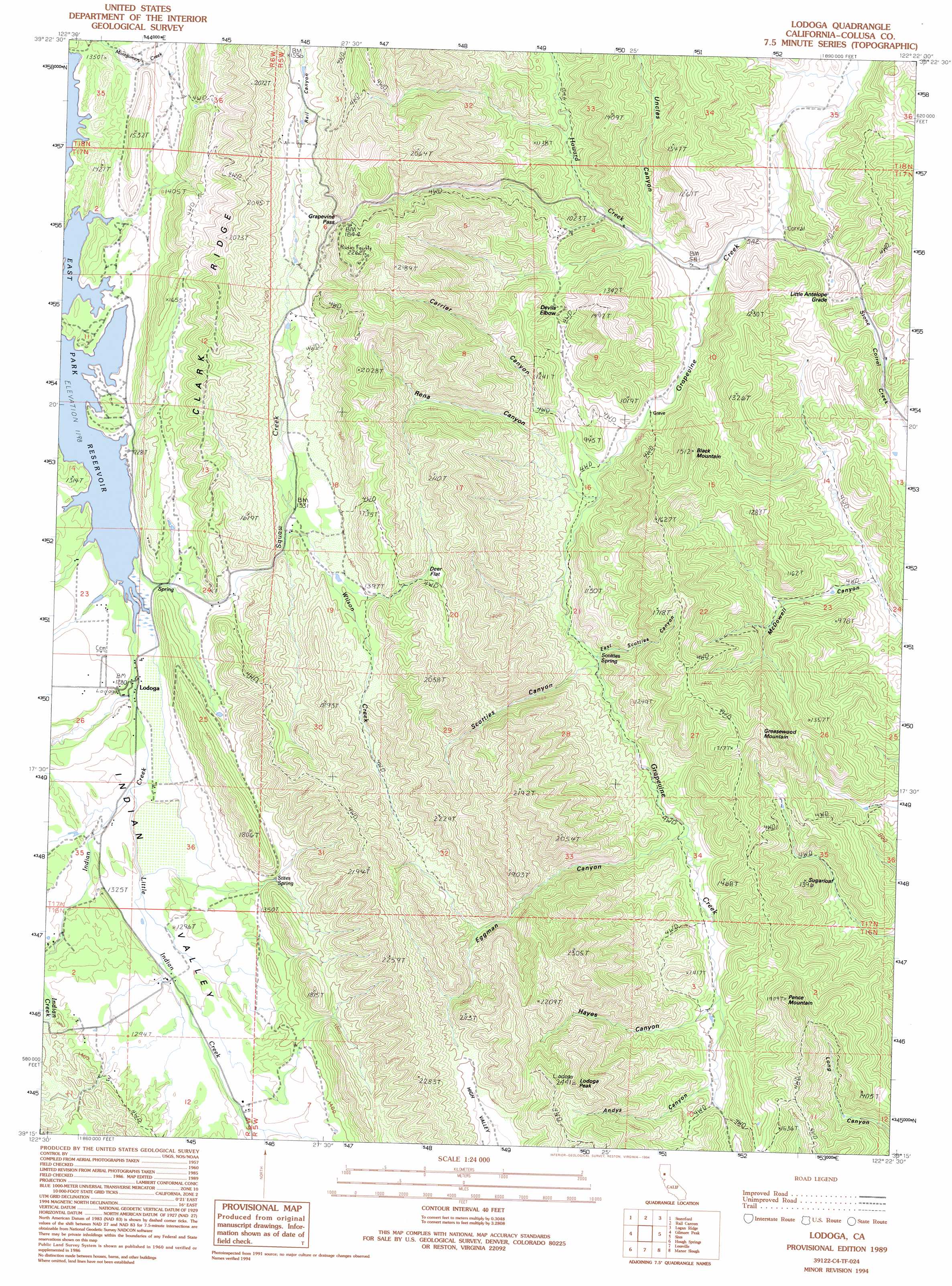
Lodoga Topo Map California
To zoom in, hover over the map of Lodoga
USGS Topo Quad 39122c4 - 1:24,000 scale
| Topo Map Name: | Lodoga |
| USGS Topo Quad ID: | 39122c4 |
| Print Size: | ca. 21 1/4" wide x 27" high |
| Southeast Coordinates: | 39.25° N latitude / 122.375° W longitude |
| Map Center Coordinates: | 39.3125° N latitude / 122.4375° W longitude |
| U.S. State: | CA |
| Filename: | o39122c4.jpg |
| Download Map JPG Image: | Lodoga topo map 1:24,000 scale |
| Map Type: | Topographic |
| Topo Series: | 7.5´ |
| Map Scale: | 1:24,000 |
| Source of Map Images: | United States Geological Survey (USGS) |
| Alternate Map Versions: |
Lodoga CA 1989, updated 1989 Download PDF Buy paper map Lodoga CA 1989, updated 1994 Download PDF Buy paper map Lodoga CA 2012 Download PDF Buy paper map Lodoga CA 2015 Download PDF Buy paper map |
1:24,000 Topo Quads surrounding Lodoga
Felkner Hill |
Elk Creek |
Fruto |
Stone Valley |
Willows |
Saint John Mountain |
Stonyford |
Rail Canyon |
Logan Ridge |
Logandale |
Fouts Springs |
Gilmore Peak |
Lodoga |
Sites |
Maxwell |
Bartlett Springs |
Hough Springs |
Leesville |
Manor Slough |
Williams |
Clearlake Oaks |
Benmore Canyon |
Wilbur Springs |
Salt Canyon |
Cortina Creek |
> Back to 39122a1 at 1:100,000 scale
> Back to 39122a1 at 1:250,000 scale
> Back to U.S. Topo Maps home
Lodoga topo map: Gazetteer
Lodoga: Airports
Indian Ranch Airport elevation 388m 1272′Lodoga: Flats
Deer Flat elevation 463m 1519′Lodoga: Gaps
Grapevine Pass elevation 553m 1814′Lodoga: Populated Places
Devils Elbow elevation 280m 918′Lodoga elevation 378m 1240′
Lodoga: Ridges
Clark Ridge elevation 610m 2001′Lodoga: Springs
Scotties Spring elevation 269m 882′Stites Spring elevation 426m 1397′
Lodoga: Streams
Howard Creek elevation 172m 564′Indian Creek elevation 375m 1230′
Little Indian Creek elevation 378m 1240′
Squaw Creek elevation 367m 1204′
Wilson Creek elevation 396m 1299′
Lodoga: Summits
Black Mountain elevation 389m 1276′Greasewood Mountain elevation 368m 1207′
Lodoga Peak elevation 726m 2381′
Pence Mountain elevation 565m 1853′
Sugarloaf elevation 401m 1315′
Lodoga: Valleys
Andys Canyon elevation 402m 1318′Carrier Canyon elevation 248m 813′
East Scotties Canyon elevation 279m 915′
Eggman Canyon elevation 326m 1069′
Hayes Canyon elevation 366m 1200′
McDowell Canyon elevation 144m 472′
Rena Canyon elevation 249m 816′
Scotties Canyon elevation 293m 961′
Uncles Canyon elevation 194m 636′
Lodoga digital topo map on disk
Buy this Lodoga topo map showing relief, roads, GPS coordinates and other geographical features, as a high-resolution digital map file on DVD: