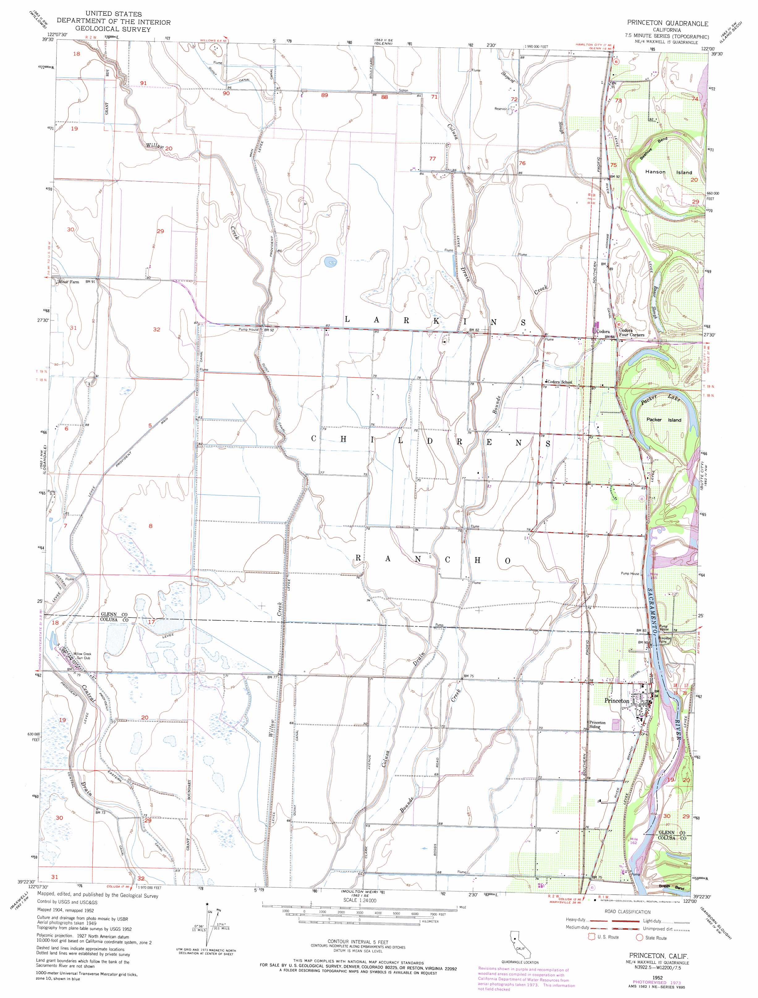
Princeton Topo Map California
To zoom in, hover over the map of Princeton
USGS Topo Quad 39122d1 - 1:24,000 scale
| Topo Map Name: | Princeton |
| USGS Topo Quad ID: | 39122d1 |
| Print Size: | ca. 21 1/4" wide x 27" high |
| Southeast Coordinates: | 39.375° N latitude / 122° W longitude |
| Map Center Coordinates: | 39.4375° N latitude / 122.0625° W longitude |
| U.S. State: | CA |
| Filename: | o39122d1.jpg |
| Download Map JPG Image: | Princeton topo map 1:24,000 scale |
| Map Type: | Topographic |
| Topo Series: | 7.5´ |
| Map Scale: | 1:24,000 |
| Source of Map Images: | United States Geological Survey (USGS) |
| Alternate Map Versions: |
Princeton CA 1952, updated 1953 Download PDF Buy paper map Princeton CA 1952, updated 1974 Download PDF Buy paper map Princeton CA 2012 Download PDF Buy paper map Princeton CA 2015 Download PDF Buy paper map |
1:24,000 Topo Quads surrounding Princeton
Fruto Ne |
Orland |
Hamilton City |
Ord Ferry |
Chico |
Stone Valley |
Willows |
Glenn |
Llano Seco |
Nelson |
Logan Ridge |
Logandale |
Princeton |
Butte City |
West Of Biggs |
Sites |
Maxwell |
Moulton Weir |
Sanborn Slough |
Pennington |
Manor Slough |
Williams |
Colusa |
Meridian |
Sutter Buttes |
> Back to 39122a1 at 1:100,000 scale
> Back to 39122a1 at 1:250,000 scale
> Back to U.S. Topo Maps home
Princeton topo map: Gazetteer
Princeton: Bends
Beehive Bend elevation 24m 78′Princeton: Canals
Central Drain elevation 23m 75′Provident Central Canal elevation 24m 78′
Provident Eastern Canal elevation 24m 78′
River Branch Canal elevation 25m 82′
Princeton: Islands
Hanson Island elevation 28m 91′Packer Island elevation 26m 85′
Princeton: Lakes
Packer Lake elevation 25m 82′Princeton: Populated Places
Codora elevation 27m 88′Princeton elevation 25m 82′
Princeton: Post Offices
Princeton Post Office elevation 25m 82′Princeton: Streams
Onemile Creek elevation 21m 68′Shepard Slough elevation 26m 85′
Princeton: Swamps
Rasnor Lakes elevation 25m 82′Princeton digital topo map on disk
Buy this Princeton topo map showing relief, roads, GPS coordinates and other geographical features, as a high-resolution digital map file on DVD: