Alder Springs Topo Map California
To zoom in, hover over the map of Alder Springs
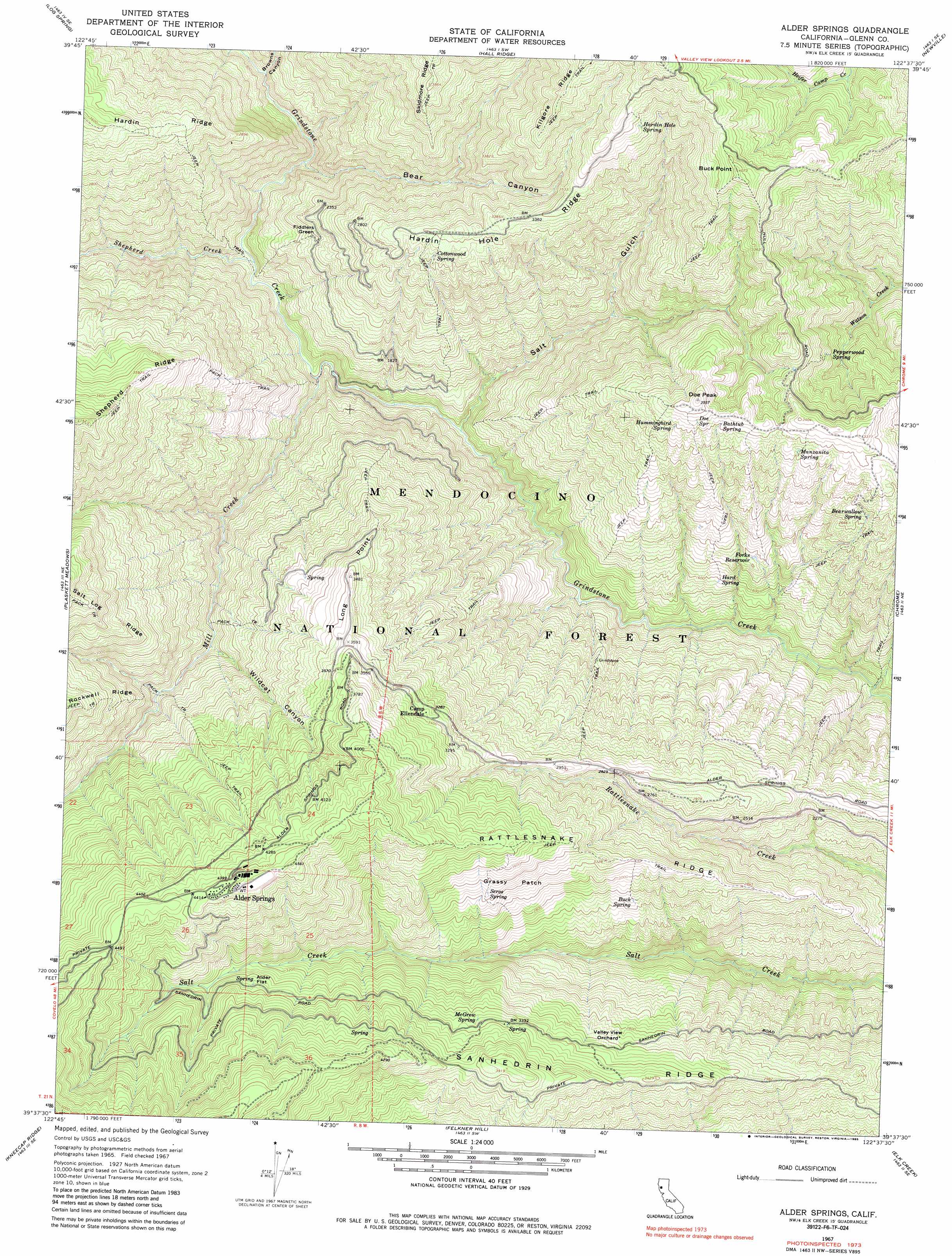
USGS Topo Quad 39122f6 - 1:24,000 scale
| Topo Map Name: | Alder Springs |
| USGS Topo Quad ID: | 39122f6 |
| Print Size: | ca. 21 1/4" wide x 27" high |
| Southeast Coordinates: | 39.625° N latitude / 122.625° W longitude |
| Map Center Coordinates: | 39.6875° N latitude / 122.6875° W longitude |
| U.S. State: | CA |
| Filename: | o39122f6.jpg |
| Download Map JPG Image: | Alder Springs topo map 1:24,000 scale |
| Map Type: | Topographic |
| Topo Series: | 7.5´ |
| Map Scale: | 1:24,000 |
| Source of Map Images: | United States Geological Survey (USGS) |
| Alternate Map Versions: |
Alder Springs CA 1967, updated 1970 Download PDF Buy paper map Alder Springs CA 1967, updated 1970 Download PDF Buy paper map Alder Springs CA 1967, updated 1985 Download PDF Buy paper map Alder Springs CA 1996, updated 2001 Download PDF Buy paper map Alder Springs CA 2012 Download PDF Buy paper map Alder Springs CA 2015 Download PDF Buy paper map |
| FStopo: | US Forest Service topo Alder Springs is available: Download FStopo PDF Download FStopo TIF |
1:24,000 Topo Quads surrounding Alder Springs
Buck Rock |
Ball Mountain |
Riley Ridge |
Paskenta |
Flournoy |
Mendocino Pass |
Log Spring |
Hall Ridge |
Newville |
Sehorn Creek |
Plaskett Ridge |
Plaskett Meadows |
Alder Springs |
Chrome |
Julian Rocks |
Hull Mountain |
Kneecap Ridge |
Felkner Hill |
Elk Creek |
Fruto |
Lake Pillsbury |
Crockett Peak |
Saint John Mountain |
Stonyford |
Rail Canyon |
> Back to 39122e1 at 1:100,000 scale
> Back to 39122a1 at 1:250,000 scale
> Back to U.S. Topo Maps home
Alder Springs topo map: Gazetteer
Alder Springs: Flats
Alder Flat elevation 1035m 3395′Grassy Patch elevation 1019m 3343′
Alder Springs: Populated Places
Alder Springs elevation 1358m 4455′Fiddlers Green elevation 687m 2253′
Reynolds Place (historical) elevation 1077m 3533′
Alder Springs: Post Offices
Alder Springs Post Office (historical) elevation 1358m 4455′Alder Springs: Reservoirs
Forks Reservoir elevation 598m 1961′Alder Springs: Ridges
Hardin Hole Ridge elevation 1008m 3307′Kilgore Ridge elevation 1215m 3986′
Long Point elevation 1065m 3494′
Rattlesnake Ridge elevation 1011m 3316′
Sanhedrin Ridge elevation 1011m 3316′
Alder Springs: Springs
Bathtub Spring elevation 980m 3215′Bearwallow Spring elevation 834m 2736′
Buck Spring elevation 828m 2716′
Cottonwood Spring elevation 928m 3044′
Doe Spring elevation 1006m 3300′
Hard Spring elevation 483m 1584′
Hardin Hole Spring elevation 1140m 3740′
Hummingbird Spring elevation 972m 3188′
Manzanita Spring elevation 940m 3083′
McGrew Spring elevation 1016m 3333′
Pepperwood Spring elevation 810m 2657′
Seros Spring elevation 997m 3270′
Alder Springs: Streams
Mill Creek elevation 365m 1197′Shepherd Creek elevation 390m 1279′
Alder Springs: Summits
Buck Point elevation 1240m 4068′Doe Peak elevation 1077m 3533′
Alder Springs: Valleys
Bear Canyon elevation 448m 1469′Browns Canyon elevation 493m 1617′
Salt Gulch elevation 348m 1141′
Wildcat Canyon elevation 626m 2053′
Alder Springs digital topo map on disk
Buy this Alder Springs topo map showing relief, roads, GPS coordinates and other geographical features, as a high-resolution digital map file on DVD: