Plaskett Meadows Topo Map California
To zoom in, hover over the map of Plaskett Meadows
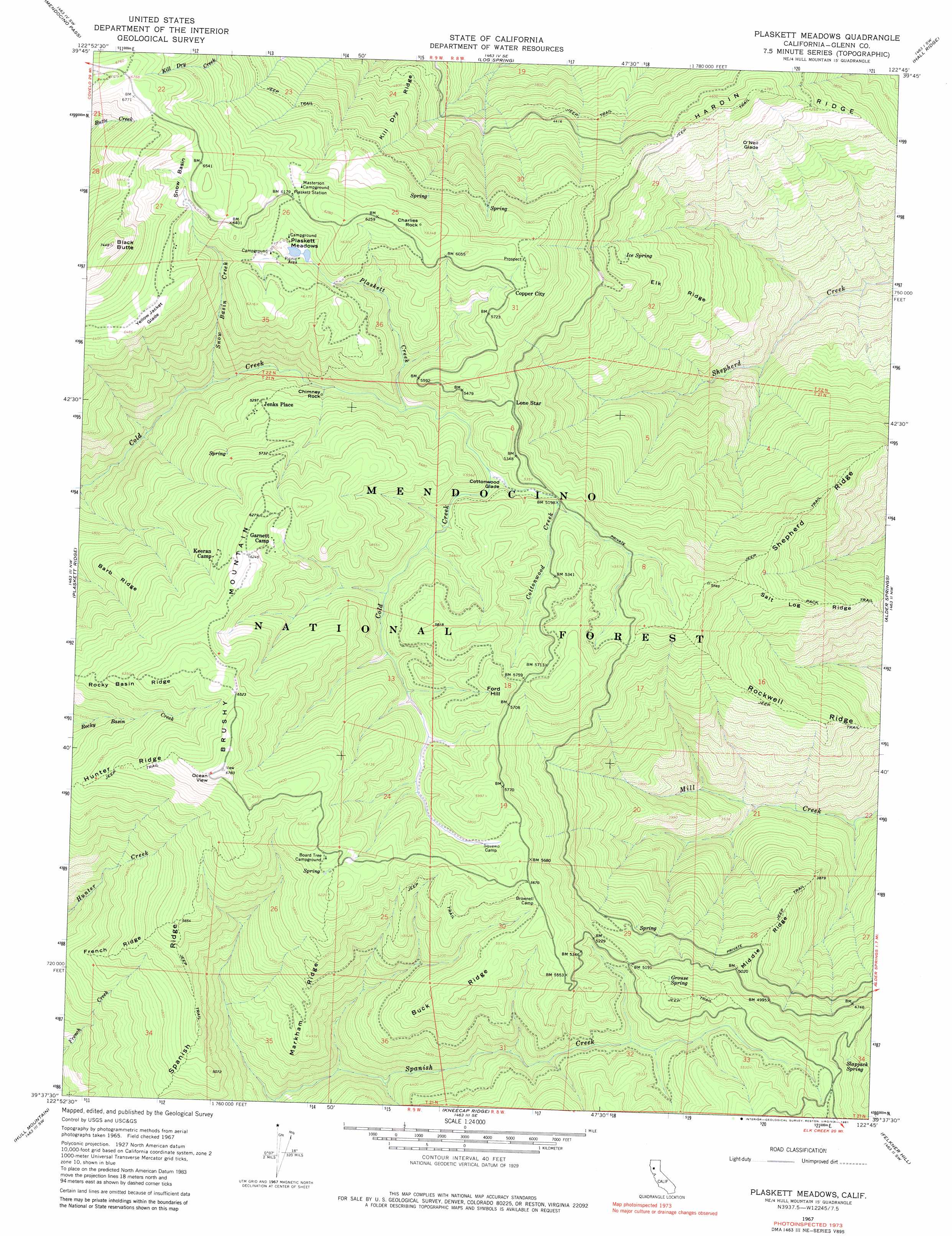
USGS Topo Quad 39122f7 - 1:24,000 scale
| Topo Map Name: | Plaskett Meadows |
| USGS Topo Quad ID: | 39122f7 |
| Print Size: | ca. 21 1/4" wide x 27" high |
| Southeast Coordinates: | 39.625° N latitude / 122.75° W longitude |
| Map Center Coordinates: | 39.6875° N latitude / 122.8125° W longitude |
| U.S. State: | CA |
| Filename: | o39122f7.jpg |
| Download Map JPG Image: | Plaskett Meadows topo map 1:24,000 scale |
| Map Type: | Topographic |
| Topo Series: | 7.5´ |
| Map Scale: | 1:24,000 |
| Source of Map Images: | United States Geological Survey (USGS) |
| Alternate Map Versions: |
Plaskett meadows CA 1967, updated 1969 Download PDF Buy paper map Plaskett meadows CA 1967, updated 1981 Download PDF Buy paper map Plaskett Meadows CA 1995, updated 2001 Download PDF Buy paper map Plaskett Meadows CA 2012 Download PDF Buy paper map Plaskett Meadows CA 2015 Download PDF Buy paper map |
| FStopo: | US Forest Service topo Plaskett Meadows is available: Download FStopo PDF Download FStopo TIF |
1:24,000 Topo Quads surrounding Plaskett Meadows
Leech Lake Mountain |
Buck Rock |
Ball Mountain |
Riley Ridge |
Paskenta |
Newhouse Ridge |
Mendocino Pass |
Log Spring |
Hall Ridge |
Newville |
Thatcher Ridge |
Plaskett Ridge |
Plaskett Meadows |
Alder Springs |
Chrome |
Sanhedrin Mountain |
Hull Mountain |
Kneecap Ridge |
Felkner Hill |
Elk Creek |
Van Arsdale Reservoir |
Lake Pillsbury |
Crockett Peak |
Saint John Mountain |
Stonyford |
> Back to 39122e1 at 1:100,000 scale
> Back to 39122a1 at 1:250,000 scale
> Back to U.S. Topo Maps home
Plaskett Meadows topo map: Gazetteer
Plaskett Meadows: Basins
Snow Basin elevation 1961m 6433′Plaskett Meadows: Flats
Cottonwood Glade elevation 1572m 5157′O'Neil Glade elevation 1255m 4117′
Plaskett Meadows elevation 1813m 5948′
Yellow Jacket Glade elevation 1956m 6417′
Plaskett Meadows: Pillars
Charlies Rock elevation 1918m 6292′Chimney Rock elevation 1568m 5144′
Plaskett Meadows: Populated Places
Copper City elevation 1779m 5836′Jenks Place elevation 1614m 5295′
Lone Star elevation 1613m 5291′
Plaskett Meadows: Ridges
Barb Ridge elevation 1653m 5423′Buck Ridge elevation 1722m 5649′
Elk Ridge elevation 1290m 4232′
French Ridge elevation 1477m 4845′
Hardin Ridge elevation 1452m 4763′
Hunter Ridge elevation 1926m 6318′
Kill Dry Ridge elevation 1538m 5045′
Markham Ridge elevation 1532m 5026′
Middle Ridge elevation 1418m 4652′
Rockwell Ridge elevation 1358m 4455′
Salt Log Ridge elevation 1460m 4790′
Shepherd Ridge elevation 1427m 4681′
Spanish Ridge elevation 1634m 5360′
Plaskett Meadows: Springs
Frolic Spring elevation 1178m 3864′Grouse Spring elevation 1645m 5396′
Ice Spring elevation 1383m 4537′
Slapjack Spring elevation 1560m 5118′
Plaskett Meadows: Streams
Cottonwood Creek elevation 1579m 5180′Plaskett Creek elevation 1545m 5068′
Snow Basin Creek elevation 1388m 4553′
Plaskett Meadows: Summits
Black Butte elevation 2252m 7388′Brushy Mountain elevation 2053m 6735′
Ford Hill elevation 1813m 5948′
Plaskett Meadows digital topo map on disk
Buy this Plaskett Meadows topo map showing relief, roads, GPS coordinates and other geographical features, as a high-resolution digital map file on DVD: