Vina Topo Map California
To zoom in, hover over the map of Vina
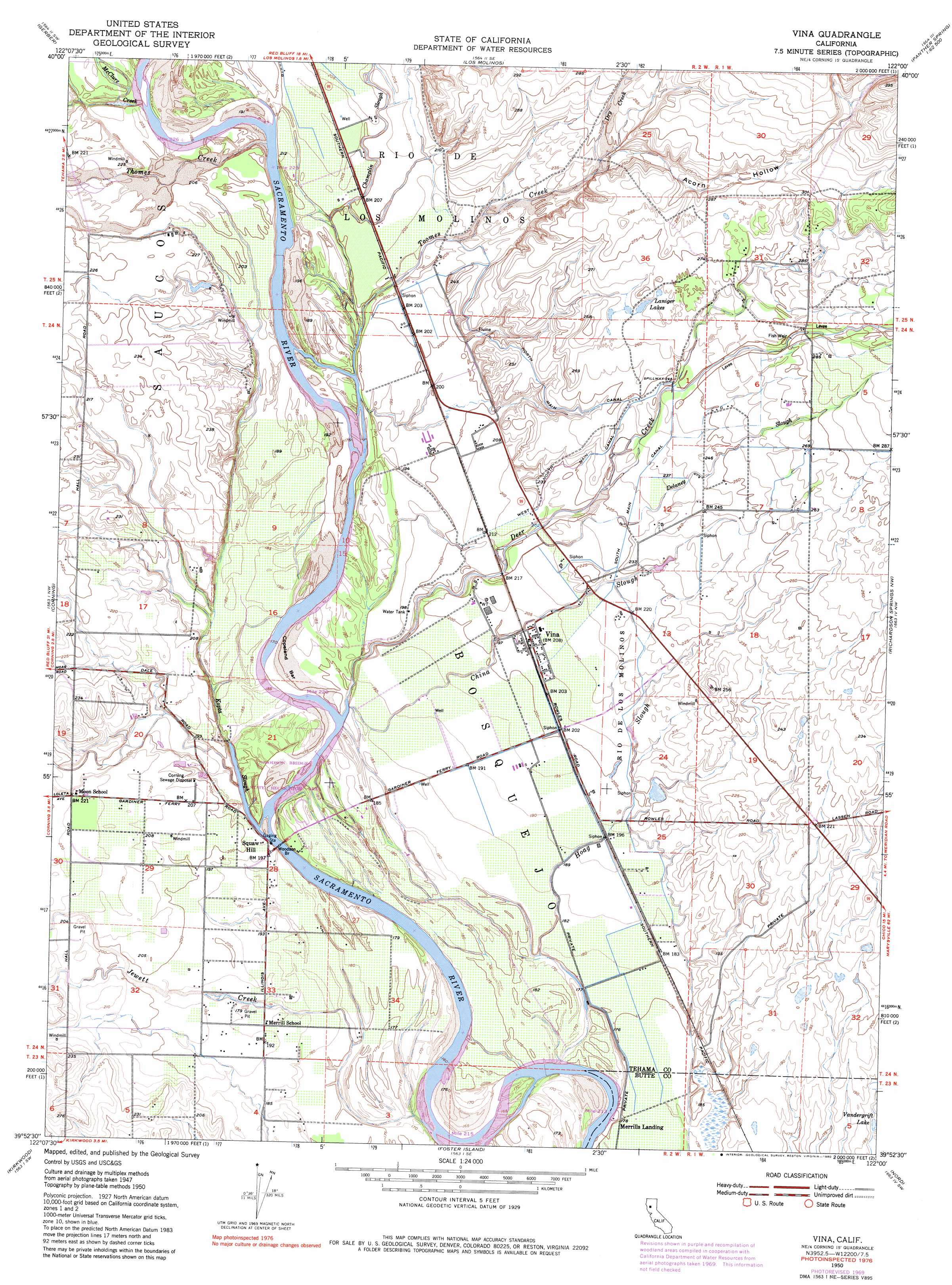
USGS Topo Quad 39122h1 - 1:24,000 scale
| Topo Map Name: | Vina |
| USGS Topo Quad ID: | 39122h1 |
| Print Size: | ca. 21 1/4" wide x 27" high |
| Southeast Coordinates: | 39.875° N latitude / 122° W longitude |
| Map Center Coordinates: | 39.9375° N latitude / 122.0625° W longitude |
| U.S. State: | CA |
| Filename: | o39122h1.jpg |
| Download Map JPG Image: | Vina topo map 1:24,000 scale |
| Map Type: | Topographic |
| Topo Series: | 7.5´ |
| Map Scale: | 1:24,000 |
| Source of Map Images: | United States Geological Survey (USGS) |
| Alternate Map Versions: |
Vina CA 1950, updated 1957 Download PDF Buy paper map Vina CA 1950, updated 1970 Download PDF Buy paper map Vina CA 1950, updated 1980 Download PDF Buy paper map Vina CA 1951, updated 1951 Download PDF Buy paper map Vina CA 2012 Download PDF Buy paper map Vina CA 2015 Download PDF Buy paper map |
1:24,000 Topo Quads surrounding Vina
Red Bluff West |
Red Bluff East |
Tuscan Springs |
Dewitt Peak |
Panther Spring |
West Of Gerber |
Gerber |
Los Molinos |
Acorn Hollow |
Ishi Caves |
Henleyville |
Corning |
Vina |
Richardson Springs Nw |
Campbell Mound |
Black Butte Dam |
Kirkwood |
Foster Island |
Nord |
Richardson Springs |
Fruto Ne |
Orland |
Hamilton City |
Ord Ferry |
Chico |
> Back to 39122e1 at 1:100,000 scale
> Back to 39122a1 at 1:250,000 scale
> Back to U.S. Topo Maps home
Vina topo map: Gazetteer
Vina: Bars
Copeland Bar elevation 54m 177′Moone Bar elevation 53m 173′
Vina: Bends
Hazel Bend elevation 46m 150′Vina: Bridges
Woodson Bridge elevation 50m 164′Vina: Canals
North Main Canal elevation 72m 236′South Main Canal elevation 71m 232′
West North Main Canal elevation 74m 242′
Vina: Crossings
Squaw Hill Ferry (historical) elevation 50m 164′Vina: Guts
Vina Slough elevation 56m 183′Vina: Islands
Blethen Island elevation 59m 193′Island Number One (historical) elevation 50m 164′
Vina: Parks
Tehama County River Park elevation 57m 187′Woodson Bridge State Recreation Area elevation 53m 173′
Vina: Populated Places
Copeland elevation 63m 206′Ensign (historical) elevation 63m 206′
Merrills Landing elevation 54m 177′
Soto (historical) elevation 56m 183′
Squaw Hill elevation 60m 196′
Vina elevation 64m 209′
Vina: Rapids
Captain Jones Rapids elevation 51m 167′Plumas Rapids (historical) elevation 59m 193′
Vina: Streams
Champlin Slough elevation 55m 180′China Slough elevation 57m 187′
Deer Creek elevation 55m 180′
Delaney Slough elevation 63m 206′
Dry Creek elevation 76m 249′
Hoag Slough elevation 49m 160′
Jewett Creek elevation 48m 157′
Kopta Slough elevation 50m 164′
McClure Creek elevation 57m 187′
Thomes Creek elevation 56m 183′
Toomes Creek elevation 62m 203′
Vina: Valleys
Acorn Hollow elevation 79m 259′Vina digital topo map on disk
Buy this Vina topo map showing relief, roads, GPS coordinates and other geographical features, as a high-resolution digital map file on DVD: