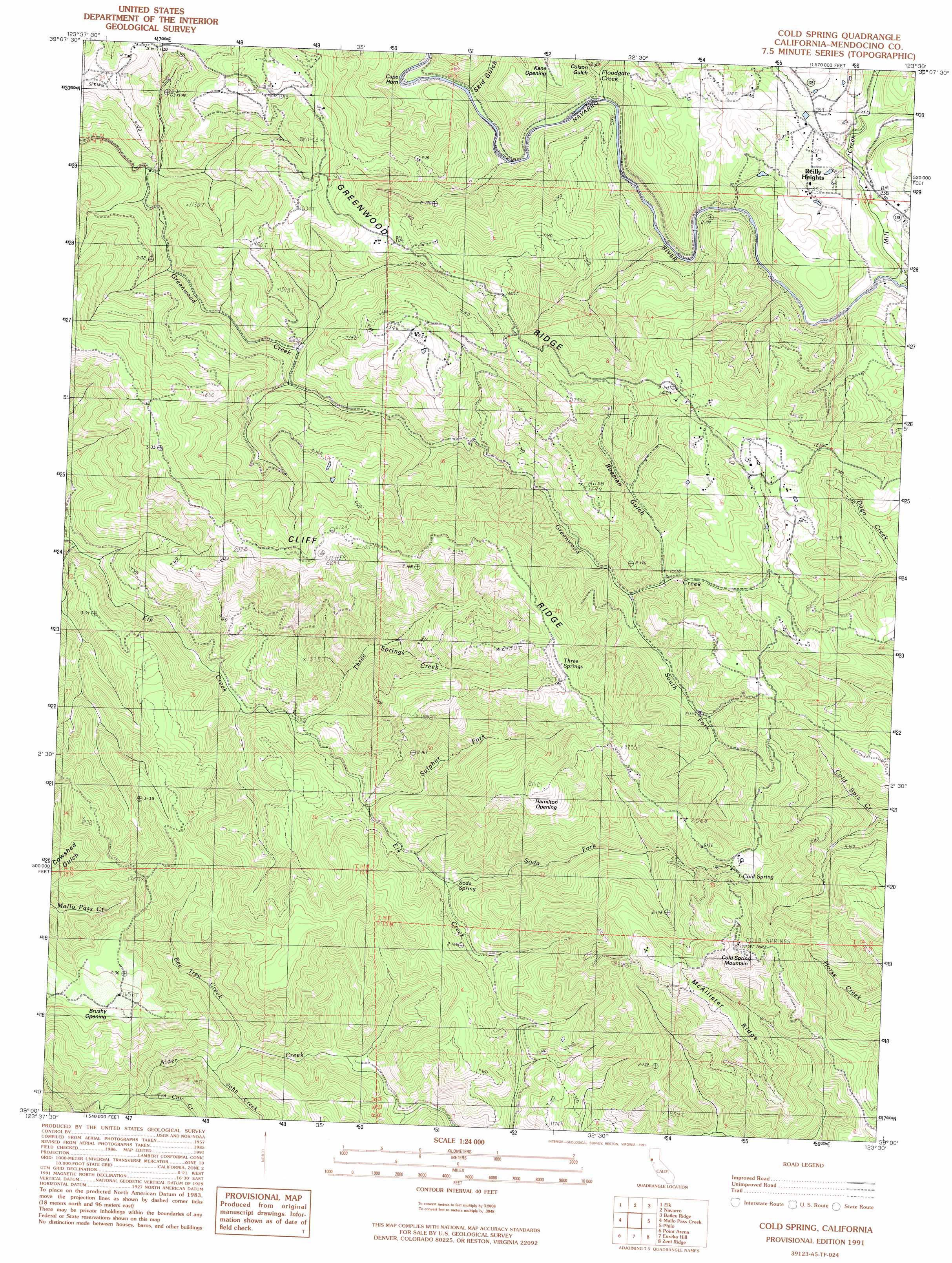
Cold Spring Topo Map California
To zoom in, hover over the map of Cold Spring
USGS Topo Quad 39123a5 - 1:24,000 scale
| Topo Map Name: | Cold Spring |
| USGS Topo Quad ID: | 39123a5 |
| Print Size: | ca. 21 1/4" wide x 27" high |
| Southeast Coordinates: | 39° N latitude / 123.5° W longitude |
| Map Center Coordinates: | 39.0625° N latitude / 123.5625° W longitude |
| U.S. State: | CA |
| Filename: | o39123a5.jpg |
| Download Map JPG Image: | Cold Spring topo map 1:24,000 scale |
| Map Type: | Topographic |
| Topo Series: | 7.5´ |
| Map Scale: | 1:24,000 |
| Source of Map Images: | United States Geological Survey (USGS) |
| Alternate Map Versions: |
Cold Spring CA 1991, updated 1991 Download PDF Buy paper map Cold Spring CA 2012 Download PDF Buy paper map Cold Spring CA 2015 Download PDF Buy paper map |
1:24,000 Topo Quads surrounding Cold Spring
Mendocino |
Mathison Peak |
Comptche |
Greenough Ridge |
Laughlin Range |
Albion |
Elk |
Navarro |
Bailey Ridge |
Orrs Springs |
Mallo Pass Creek |
Cold Spring |
Philo |
Boonville |
|
Point Arena |
Eureka Hill |
Zeni Ridge |
Ornbaun Valley |
|
Saunders Reef |
Gualala |
Mcguire Ridge |
Gube Mountain |
> Back to 39123a1 at 1:100,000 scale
> Back to 39122a1 at 1:250,000 scale
> Back to U.S. Topo Maps home
Cold Spring topo map: Gazetteer
Cold Spring: Capes
Cape Horn elevation 24m 78′Cold Spring: Flats
Brushy Opening elevation 506m 1660′Hamilton Opening elevation 634m 2080′
Kane Opening elevation 200m 656′
Cold Spring: Populated Places
Reilly Heights elevation 107m 351′Cold Spring: Ridges
McAllister Ridge elevation 602m 1975′Cold Spring: Springs
Cold Spring elevation 642m 2106′Soda Spring elevation 202m 662′
Three Springs elevation 643m 2109′
Cold Spring: Streams
Bee Tree Creek elevation 158m 518′Floodgate Creek elevation 34m 111′
John Creek elevation 164m 538′
Lazy Creek elevation 51m 167′
Mill Creek elevation 37m 121′
Nye Creek elevation 132m 433′
Soda Fork elevation 202m 662′
South Fork Greenwood Creek elevation 299m 980′
Sulphur Fork elevation 179m 587′
Three Springs Creek elevation 159m 521′
Tin Can Creek elevation 154m 505′
Cold Spring: Summits
Cold Spring Mountain elevation 815m 2673′Cold Spring: Valleys
Colson Gulch elevation 39m 127′Meyer Gulch elevation 82m 269′
Russian Gulch elevation 303m 994′
Skid Gulch elevation 42m 137′
Cold Spring digital topo map on disk
Buy this Cold Spring topo map showing relief, roads, GPS coordinates and other geographical features, as a high-resolution digital map file on DVD: