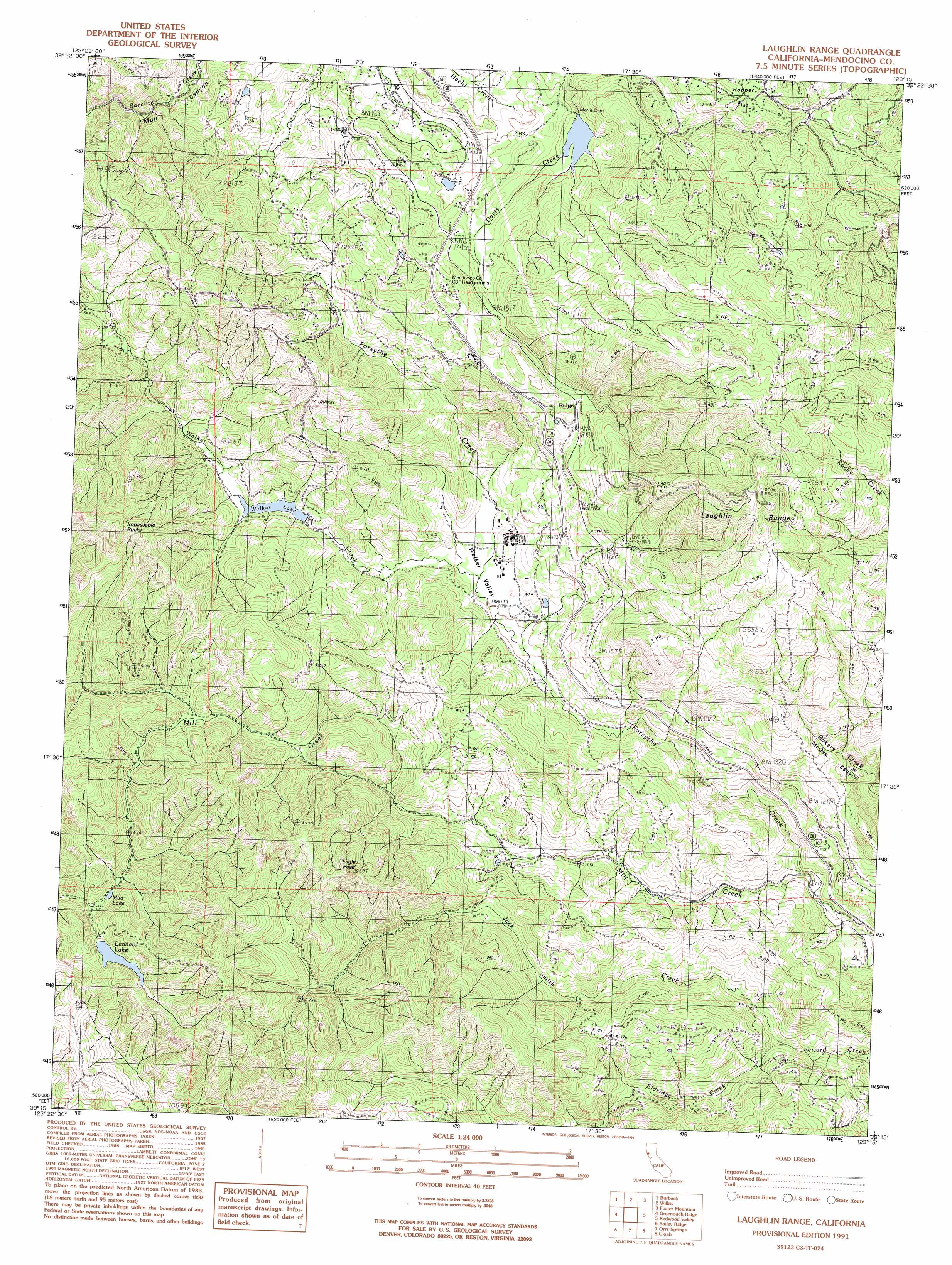
Laughlin Range Topo Map California
To zoom in, hover over the map of Laughlin Range
USGS Topo Quad 39123c3 - 1:24,000 scale
| Topo Map Name: | Laughlin Range |
| USGS Topo Quad ID: | 39123c3 |
| Print Size: | ca. 21 1/4" wide x 27" high |
| Southeast Coordinates: | 39.25° N latitude / 123.25° W longitude |
| Map Center Coordinates: | 39.3125° N latitude / 123.3125° W longitude |
| U.S. State: | CA |
| Filename: | o39123c3.jpg |
| Download Map JPG Image: | Laughlin Range topo map 1:24,000 scale |
| Map Type: | Topographic |
| Topo Series: | 7.5´ |
| Map Scale: | 1:24,000 |
| Source of Map Images: | United States Geological Survey (USGS) |
| Alternate Map Versions: |
Laughlin Range CA 1991, updated 1991 Download PDF Buy paper map Laughlin Range CA 2012 Download PDF Buy paper map Laughlin Range CA 2015 Download PDF Buy paper map |
1:24,000 Topo Quads surrounding Laughlin Range
Sherwood Peak |
Longvale |
Willis Ridge |
Brushy Mountain |
Sanhedrin Mountain |
Northspur |
Burbeck |
Willits |
Foster Mountain |
Van Arsdale Reservoir |
Comptche |
Greenough Ridge |
Laughlin Range |
Redwood Valley |
Potter Valley |
Navarro |
Bailey Ridge |
Orrs Springs |
Ukiah |
Cow Mountain |
Cold Spring |
Philo |
Boonville |
Elledge Peak |
Purdys Gardens |
> Back to 39123a1 at 1:100,000 scale
> Back to 39122a1 at 1:250,000 scale
> Back to U.S. Topo Maps home
Laughlin Range topo map: Gazetteer
Laughlin Range: Dams
Morris Dam elevation 492m 1614′Ridgewood 382 Dam elevation 390m 1279′
Laughlin Range: Flats
Hopper Flat elevation 650m 2132′Laughlin Range: Lakes
Mud Lake elevation 510m 1673′Laughlin Range: Populated Places
Ridge elevation 584m 1916′Ridgewood Park elevation 664m 2178′
Laughlin Range: Reservoirs
Leonard Lake elevation 549m 1801′Walker Lake elevation 390m 1279′
Laughlin Range: Streams
Eldridge Creek (historical) elevation 275m 902′Jack Smith Creek elevation 270m 885′
Mill Creek elevation 239m 784′
Walker Creek elevation 361m 1184′
Laughlin Range: Summits
Eagle Peak elevation 750m 2460′Impassable Rocks elevation 781m 2562′
Laughlin Range elevation 1000m 3280′
Laughlin Range: Valleys
Walker Valley elevation 361m 1184′Laughlin Range digital topo map on disk
Buy this Laughlin Range topo map showing relief, roads, GPS coordinates and other geographical features, as a high-resolution digital map file on DVD: