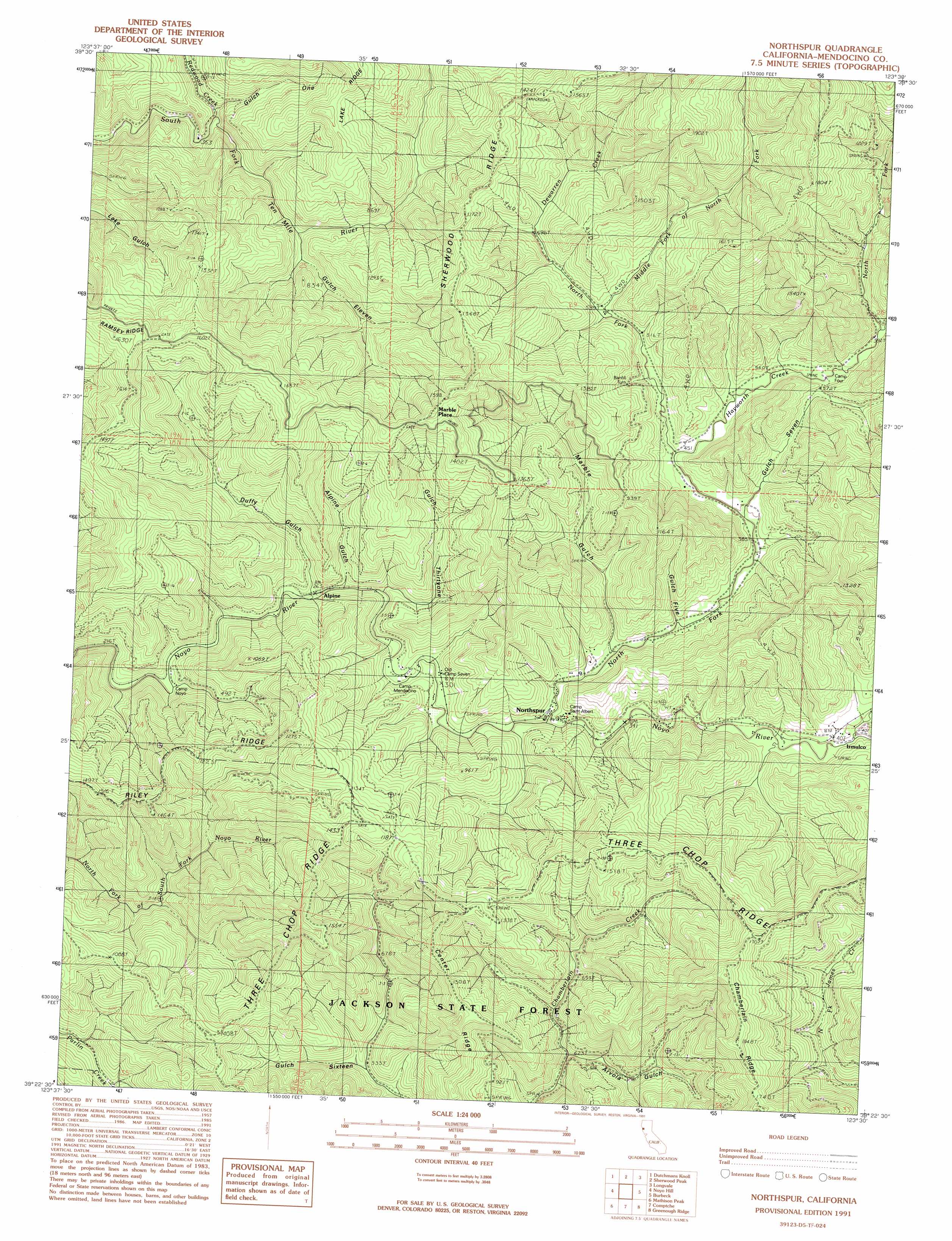
Northspur Topo Map California
To zoom in, hover over the map of Northspur
USGS Topo Quad 39123d5 - 1:24,000 scale
| Topo Map Name: | Northspur |
| USGS Topo Quad ID: | 39123d5 |
| Print Size: | ca. 21 1/4" wide x 27" high |
| Southeast Coordinates: | 39.375° N latitude / 123.5° W longitude |
| Map Center Coordinates: | 39.4375° N latitude / 123.5625° W longitude |
| U.S. State: | CA |
| Filename: | o39123d5.jpg |
| Download Map JPG Image: | Northspur topo map 1:24,000 scale |
| Map Type: | Topographic |
| Topo Series: | 7.5´ |
| Map Scale: | 1:24,000 |
| Source of Map Images: | United States Geological Survey (USGS) |
| Alternate Map Versions: |
Northspur CA 1991, updated 1991 Download PDF Buy paper map Northspur CA 2012 Download PDF Buy paper map Northspur CA 2015 Download PDF Buy paper map |
1:24,000 Topo Quads surrounding Northspur
Westport |
Lincoln Ridge |
Cahto Peak |
Laytonville |
Dos Rios |
Inglenook |
Dutchmans Knoll |
Sherwood Peak |
Longvale |
Willis Ridge |
Fort Bragg |
Noyo Hill |
Northspur |
Burbeck |
Willits |
Mendocino |
Mathison Peak |
Comptche |
Greenough Ridge |
Laughlin Range |
Albion |
Elk |
Navarro |
Bailey Ridge |
Orrs Springs |
> Back to 39123a1 at 1:100,000 scale
> Back to 39122a1 at 1:250,000 scale
> Back to U.S. Topo Maps home
Northspur topo map: Gazetteer
Northspur: Populated Places
Alpine elevation 71m 232′Irmulco elevation 133m 436′
Marble Place elevation 461m 1512′
Northspur elevation 109m 357′
Wanhala elevation 161m 528′
Northspur: Ridges
Center Ridge elevation 359m 1177′Three Chop Ridge elevation 420m 1377′
Northspur: Streams
Dewarren Creek elevation 204m 669′Hayworth Creek elevation 126m 413′
Middle Fork of North Fork Noyo River elevation 162m 531′
North Fork Hayworth Creek elevation 176m 577′
North Fork James Creek elevation 238m 780′
North Fork Noyo River elevation 90m 295′
Olds Creek elevation 123m 403′
Redwood Creek elevation 171m 561′
Northspur: Valleys
Alpine Gulch elevation 89m 291′Arvola Gulch elevation 171m 561′
Camp Ten Gulch elevation 152m 498′
Duffy Gulch elevation 83m 272′
Gulch Eleven elevation 219m 718′
Gulch Five elevation 105m 344′
Gulch One elevation 155m 508′
Gulch Seven elevation 114m 374′
Gulch Sixteen elevation 171m 561′
Gulch Thirtyone elevation 72m 236′
Marble Gulch elevation 102m 334′
Northspur digital topo map on disk
Buy this Northspur topo map showing relief, roads, GPS coordinates and other geographical features, as a high-resolution digital map file on DVD: