Fort Bragg Topo Map California
To zoom in, hover over the map of Fort Bragg
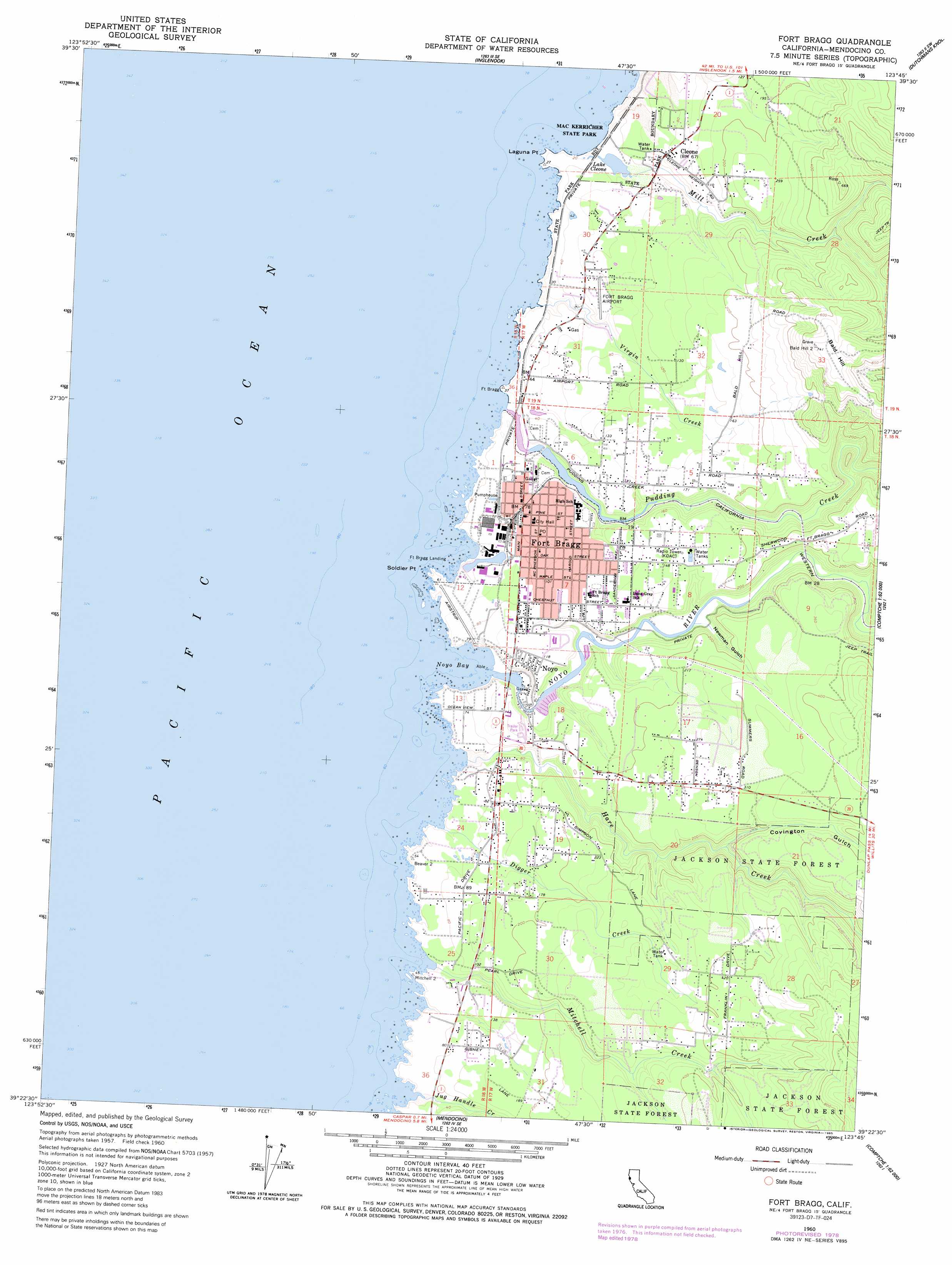
USGS Topo Quad 39123d7 - 1:24,000 scale
| Topo Map Name: | Fort Bragg |
| USGS Topo Quad ID: | 39123d7 |
| Print Size: | ca. 21 1/4" wide x 27" high |
| Southeast Coordinates: | 39.375° N latitude / 123.75° W longitude |
| Map Center Coordinates: | 39.4375° N latitude / 123.8125° W longitude |
| U.S. State: | CA |
| Filename: | o39123d7.jpg |
| Download Map JPG Image: | Fort Bragg topo map 1:24,000 scale |
| Map Type: | Topographic |
| Topo Series: | 7.5´ |
| Map Scale: | 1:24,000 |
| Source of Map Images: | United States Geological Survey (USGS) |
| Alternate Map Versions: |
Fort Bragg CA 1960, updated 1962 Download PDF Buy paper map Fort Bragg CA 1960, updated 1968 Download PDF Buy paper map Fort Bragg CA 1960, updated 1980 Download PDF Buy paper map Fort Bragg CA 1960, updated 1985 Download PDF Buy paper map Fort Bragg CA 1960, updated 1985 Download PDF Buy paper map Fort Bragg CA 2012 Download PDF Buy paper map Fort Bragg CA 2015 Download PDF Buy paper map |
1:24,000 Topo Quads surrounding Fort Bragg
Westport |
Lincoln Ridge |
Cahto Peak |
||
Inglenook |
Dutchmans Knoll |
Sherwood Peak |
||
Fort Bragg |
Noyo Hill |
Northspur |
||
Mendocino |
Mathison Peak |
Comptche |
||
Albion |
Elk |
Navarro |
> Back to 39123a1 at 1:100,000 scale
> Back to 39122a1 at 1:250,000 scale
> Back to U.S. Topo Maps home
Fort Bragg topo map: Gazetteer
Fort Bragg: Airports
Fort Bragg Airport elevation 21m 68′Fort Bragg: Bays
Dolphin Cove elevation 8m 26′Noyo Basin elevation 9m 29′
Noyo Bay elevation 0m 0′
Fort Bragg: Beaches
Laguna Point Beach elevation 2m 6′Pudding Creek Beach elevation 5m 16′
Fort Bragg: Capes
Beaver Point elevation 16m 52′Laguna Point elevation 7m 22′
Soldier Point elevation 6m 19′
Todd Point elevation 13m 42′
Fort Bragg: Dams
Mill Pond 2381 Dam elevation 14m 45′Fort Bragg: Harbors
Noyo Anchorage elevation 5m 16′Fort Bragg: Islands
Seal Rocks elevation 0m 0′Fort Bragg: Lakes
Lake Cleone elevation 9m 29′Fort Bragg: Parks
Green Memorial Park elevation 39m 127′MacKerricher State Park elevation 12m 39′
Main Street Historic Commercial District elevation 21m 68′
Otis R Johnson Park elevation 26m 85′
Fort Bragg: Populated Places
Cleone elevation 24m 78′Fort Bragg elevation 26m 85′
Heeser Addition elevation 95m 311′
Noyo elevation 33m 108′
Fort Bragg: Post Offices
Fort Bragg Post Office elevation 31m 101′Fort Bragg: Streams
Digger Creek elevation 5m 16′Hare Creek elevation 1m 3′
Jug Handle Creek elevation 4m 13′
Mill Creek elevation 9m 29′
Mitchell Creek elevation 4m 13′
Noyo River elevation 2m 6′
Pudding Creek elevation 1m 3′
Virgin Creek elevation 2m 6′
Fort Bragg: Summits
Bald Hill elevation 235m 770′Fort Bragg: Trails
Laguna Trail elevation 12m 39′Fort Bragg: Valleys
Covington Gulch elevation 24m 78′Newman Gulch elevation 6m 19′
Fort Bragg digital topo map on disk
Buy this Fort Bragg topo map showing relief, roads, GPS coordinates and other geographical features, as a high-resolution digital map file on DVD: