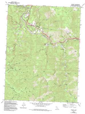
Leggett Topo Map California
To zoom in, hover over the map of Leggett
USGS Topo Quad 39123g6 - 1:24,000 scale
| Topo Map Name: | Leggett |
| USGS Topo Quad ID: | 39123g6 |
| Print Size: | ca. 21 1/4" wide x 27" high |
| Southeast Coordinates: | 39.75° N latitude / 123.625° W longitude |
| Map Center Coordinates: | 39.8125° N latitude / 123.6875° W longitude |
| U.S. State: | CA |
| Filename: | o39123g6.jpg |
| Download Map JPG Image: | Leggett topo map 1:24,000 scale |
| Map Type: | Topographic |
| Topo Series: | 7.5´ |
| Map Scale: | 1:24,000 |
| Source of Map Images: | United States Geological Survey (USGS) |
| Alternate Map Versions: |
Leggett CA 1969, updated 1974 Download PDF Buy paper map Leggett CA 1969, updated 1987 Download PDF Buy paper map Leggett CA 1969, updated 1994 Download PDF Buy paper map Leggett CA 2012 Download PDF Buy paper map Leggett CA 2015 Download PDF Buy paper map |
1:24,000 Topo Quads surrounding Leggett
> Back to 39123e1 at 1:100,000 scale
> Back to 39122a1 at 1:250,000 scale
> Back to U.S. Topo Maps home
Leggett topo map: Gazetteer
Leggett: Basins
Leggett Valley elevation 379m 1243′Leggett: Bends
Big Bend elevation 250m 820′Horseshoe Bend elevation 421m 1381′
Leggett: Flats
Big Flat elevation 326m 1069′Cedar Flat elevation 300m 984′
Dann Valley elevation 312m 1023′
Winkie Flat elevation 337m 1105′
Leggett: Gaps
Low Gap elevation 544m 1784′Pedro Opening elevation 869m 2851′
Leggett: Populated Places
Cummings elevation 405m 1328′Leggett elevation 300m 984′
South Leggett elevation 339m 1112′
Underwood Park elevation 304m 997′
Leggett: Ridges
Elkhorn Ridge elevation 693m 2273′Leggett: Streams
Big Dann Creek elevation 235m 770′Bond Creek elevation 365m 1197′
Cedar Creek elevation 237m 777′
Doctors Creek elevation 386m 1266′
Grizzly Creek elevation 236m 774′
Hogshed Creek elevation 313m 1026′
Hollow Tree Creek elevation 225m 738′
Islam John Creek elevation 313m 1026′
Little Dann Creek elevation 261m 856′
Little Low Gap Creek elevation 283m 928′
Lost Man Creek elevation 317m 1040′
Lost Pipe Creek elevation 369m 1210′
Low Gap Creek elevation 251m 823′
Lynch Creek elevation 390m 1279′
Measley Creek elevation 309m 1013′
Michaels Creek elevation 376m 1233′
Rattlesnake Creek elevation 256m 839′
Rock Creek elevation 216m 708′
Squaw Creek elevation 288m 944′
Tenmile Creek elevation 366m 1200′
Waldron Creek elevation 390m 1279′
Walters Creek elevation 330m 1082′
Wilson Creek elevation 326m 1069′
Leggett: Summits
Little Red Mountain elevation 973m 3192′Leggett: Trails
Lookout Trail elevation 426m 1397′Leggett: Valleys
Surveyors Canyon elevation 333m 1092′Leggett digital topo map on disk
Buy this Leggett topo map showing relief, roads, GPS coordinates and other geographical features, as a high-resolution digital map file on DVD:


