Updegraff Ridge Topo Map California
To zoom in, hover over the map of Updegraff Ridge
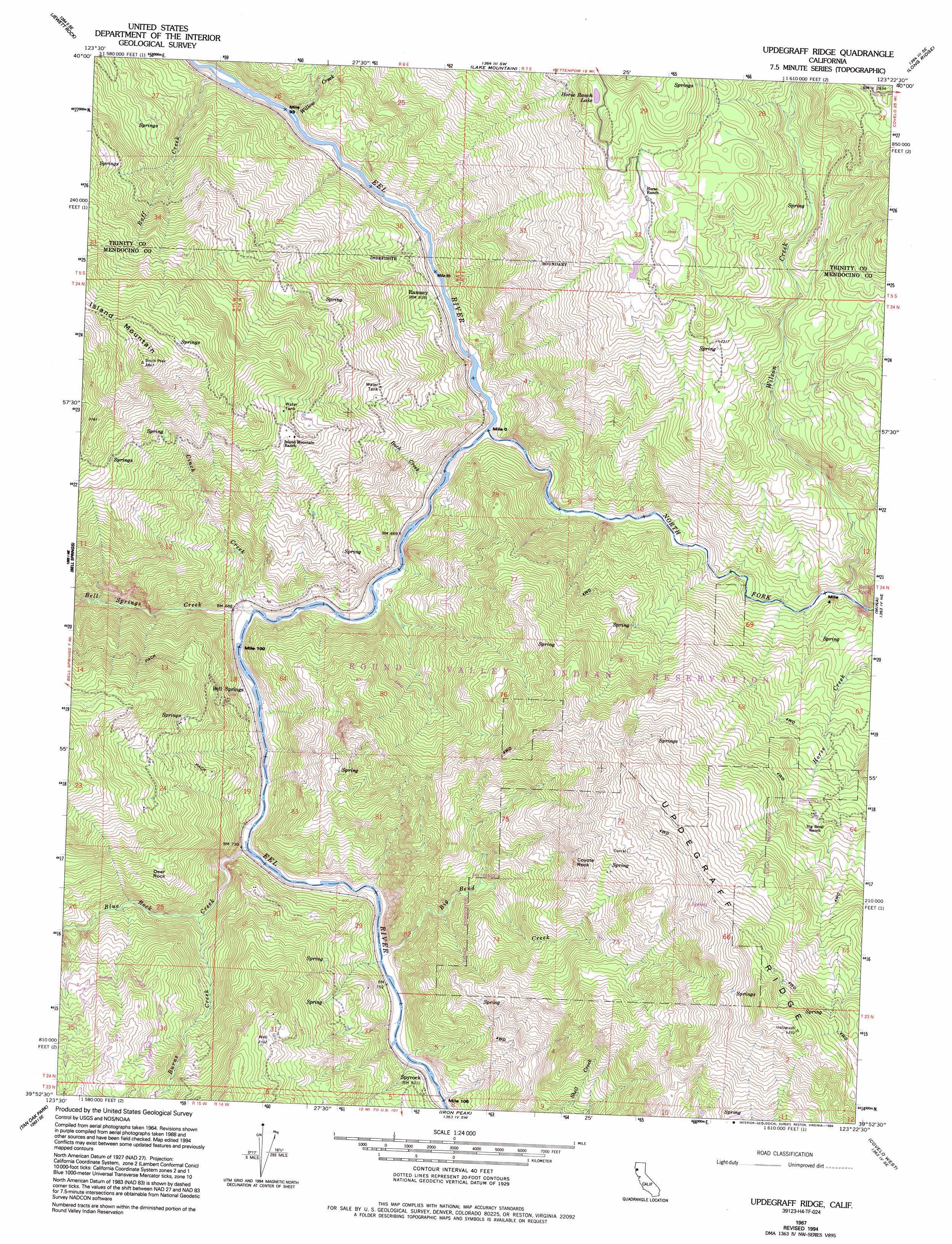
USGS Topo Quad 39123h4 - 1:24,000 scale
| Topo Map Name: | Updegraff Ridge |
| USGS Topo Quad ID: | 39123h4 |
| Print Size: | ca. 21 1/4" wide x 27" high |
| Southeast Coordinates: | 39.875° N latitude / 123.375° W longitude |
| Map Center Coordinates: | 39.9375° N latitude / 123.4375° W longitude |
| U.S. State: | CA |
| Filename: | o39123h4.jpg |
| Download Map JPG Image: | Updegraff Ridge topo map 1:24,000 scale |
| Map Type: | Topographic |
| Topo Series: | 7.5´ |
| Map Scale: | 1:24,000 |
| Source of Map Images: | United States Geological Survey (USGS) |
| Alternate Map Versions: |
Updegraff Ridge CA 1967, updated 1969 Download PDF Buy paper map Updegraff Ridge CA 1967, updated 1985 Download PDF Buy paper map Updegraff Ridge CA 1967, updated 1994 Download PDF Buy paper map Updegraff Ridge CA 2012 Download PDF Buy paper map Updegraff Ridge CA 2015 Download PDF Buy paper map |
1:24,000 Topo Quads surrounding Updegraff Ridge
Fort Seward |
Alderpoint |
Zenia |
Shannon Butte |
|
Harris |
Jewett Rock |
Lake Mountain |
Long Ridge |
|
Noble Butte |
Bell Springs |
Updegraff Ridge |
Mina |
Bluenose Ridge |
Leggett |
Tan Oak Park |
Iron Peak |
Covelo West |
Covelo East |
Lincoln Ridge |
Cahto Peak |
Laytonville |
Dos Rios |
Jamison Ridge |
> Back to 39123e1 at 1:100,000 scale
> Back to 39122a1 at 1:250,000 scale
> Back to U.S. Topo Maps home
Updegraff Ridge topo map: Gazetteer
Updegraff Ridge: Lakes
Horse Ranch Lake elevation 1026m 3366′Updegraff Ridge: Populated Places
Ramsey elevation 209m 685′Spyrock elevation 259m 849′
Updegraff Ridge: Ridges
Updegraff Ridge elevation 1107m 3631′Updegraff Ridge: Streams
Bell Springs Creek elevation 191m 626′Big Bend Creek elevation 209m 685′
Blue Rock Creek elevation 201m 659′
Buck Creek elevation 203m 666′
Burns Creek elevation 249m 816′
Cinch Creek elevation 195m 639′
North Fork Eel River elevation 175m 574′
Raff Creek elevation 156m 511′
Willow Creek elevation 156m 511′
Wilson Creek elevation 268m 879′
Updegraff Ridge: Summits
Coyote Rock elevation 718m 2355′Island Mountain elevation 1170m 3838′
Updegraff Ridge digital topo map on disk
Buy this Updegraff Ridge topo map showing relief, roads, GPS coordinates and other geographical features, as a high-resolution digital map file on DVD: