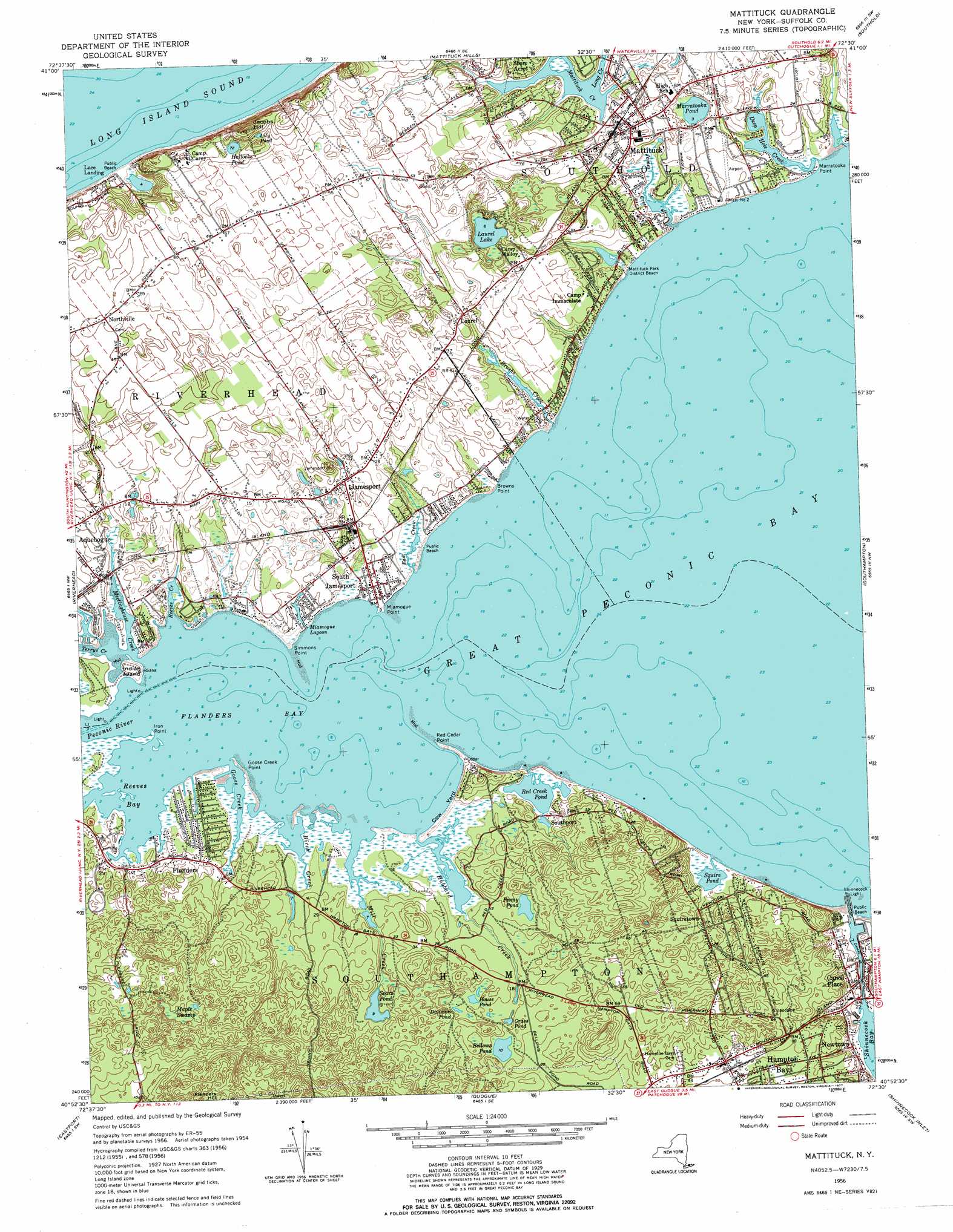
Mattituck Topo Map New York
To zoom in, hover over the map of Mattituck
USGS Topo Quad 40072h5 - 1:24,000 scale
| Topo Map Name: | Mattituck |
| USGS Topo Quad ID: | 40072h5 |
| Print Size: | ca. 21 1/4" wide x 27" high |
| Southeast Coordinates: | 40.875° N latitude / 72.5° W longitude |
| Map Center Coordinates: | 40.9375° N latitude / 72.5625° W longitude |
| U.S. State: | NY |
| Filename: | o40072h5.jpg |
| Download Map JPG Image: | Mattituck topo map 1:24,000 scale |
| Map Type: | Topographic |
| Topo Series: | 7.5´ |
| Map Scale: | 1:24,000 |
| Source of Map Images: | United States Geological Survey (USGS) |
| Alternate Map Versions: |
Mattituck NY 1947 Download PDF Buy paper map Mattituck NY 1956, updated 1958 Download PDF Buy paper map Mattituck NY 1956, updated 1966 Download PDF Buy paper map Mattituck NY 1956, updated 1977 Download PDF Buy paper map Mattituck NY 1956, updated 1977 Download PDF Buy paper map Mattituck NY 2010 Download PDF Buy paper map Mattituck NY 2013 Download PDF Buy paper map Mattituck NY 2016 Download PDF Buy paper map |
1:24,000 Topo Quads surrounding Mattituck
Orient |
||||
Mattituck Hills |
Southold |
Greenport |
||
Wading River |
Riverhead |
Mattituck |
Southampton |
Sag Harbor |
Moriches |
Eastport |
Quogue |
Shinnecock Inlet |
|
Pattersquash Island |
> Back to 40072e1 at 1:100,000 scale
> Back to 40072a1 at 1:250,000 scale
> Back to U.S. Topo Maps home
Mattituck topo map: Gazetteer
Mattituck: Airports
Mattituck Airbase elevation 7m 22′Mattituck: Bays
Flanders Bay elevation 0m 0′Great Peconic Bay elevation 0m 0′
Reeves Bay elevation 0m 0′
Mattituck: Canals
Shinnecock Canal elevation 0m 0′Mattituck: Capes
Browns Point elevation 1m 3′Brushs Point elevation 6m 19′
Goose Creek Point elevation 0m 0′
Iron Point elevation 0m 0′
Marratooka Point elevation 0m 0′
Miamogue Point elevation 0m 0′
Red Cedar Point elevation 1m 3′
Simmons Point elevation 1m 3′
Mattituck: Islands
Indian Island elevation 3m 9′Mattituck: Lakes
Bellows Pond elevation 3m 9′Division Pond elevation 4m 13′
Grass Pond elevation 2m 6′
Hallocks Pond elevation 22m 72′
House Pond elevation 4m 13′
Laurel Lake elevation 2m 6′
Lily Pond elevation 28m 91′
Marratooka Pond elevation 1m 3′
Miamogue Lagoon elevation 0m 0′
Penny Pond elevation 4m 13′
Red Creek Pond elevation 0m 0′
Sears Pond elevation 2m 6′
Squire Pond elevation 0m 0′
Mattituck: Parks
Hubbard County Park elevation 1m 3′Mattituck Park District Beach elevation 2m 6′
Meschutt Beach County Park elevation 2m 6′
Sears - Bellows Pond County Park elevation 8m 26′
Mattituck: Populated Places
Canoe Place elevation 8m 26′Flanders elevation 2m 6′
Jamesport elevation 5m 16′
Laurel elevation 6m 19′
Mattituck elevation 5m 16′
Newtown elevation 4m 13′
Northville elevation 18m 59′
Red Creek elevation 7m 22′
Riverhaven Park elevation 0m 0′
South Jamesport elevation 1m 3′
Southport elevation 6m 19′
Squiretown elevation 6m 19′
Mattituck: Reservoirs
Birch Creek Pond elevation 2m 6′Wehrman Pond elevation 2m 6′
Mattituck: Streams
Birch Creek elevation 0m 0′Brushs Creek elevation 2m 6′
Deep Hole Creek elevation 4m 13′
East Creek elevation 0m 0′
Goose Creek elevation 0m 0′
Horton Creek elevation 0m 0′
Hubbard Creek elevation 0m 0′
James Creek elevation 11m 36′
Long Creek elevation 0m 0′
Meetinghouse Creek elevation 0m 0′
Mill Creek elevation 0m 0′
Peconic River elevation 0m 0′
Reeves Creek elevation 0m 0′
Terrys Creek elevation 0m 0′
Mattituck: Summits
Jacobs Hill elevation 40m 131′Mattituck: Swamps
Maple Swamp elevation 17m 55′Mattituck digital topo map on disk
Buy this Mattituck topo map showing relief, roads, GPS coordinates and other geographical features, as a high-resolution digital map file on DVD:
Atlantic Coast (NY, NJ, PA, DE, MD, VA, NC)
Buy digital topo maps: Atlantic Coast (NY, NJ, PA, DE, MD, VA, NC)
 map DVD")