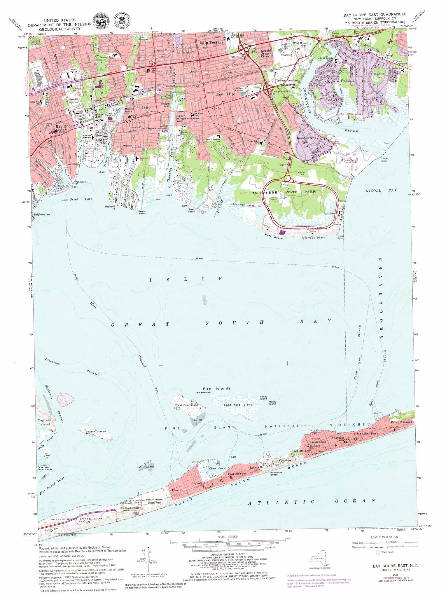
Bay Shore East Topo Map New York
To zoom in, hover over the map of Bay Shore East
USGS Topo Quad 40073f2 - 1:24,000 scale
| Topo Map Name: | Bay Shore East |
| USGS Topo Quad ID: | 40073f2 |
| Print Size: | ca. 21 1/4" wide x 27" high |
| Southeast Coordinates: | 40.625° N latitude / 73.125° W longitude |
| Map Center Coordinates: | 40.6875° N latitude / 73.1875° W longitude |
| U.S. State: | NY |
| Filename: | o40073f2.jpg |
| Download Map JPG Image: | Bay Shore East topo map 1:24,000 scale |
| Map Type: | Topographic |
| Topo Series: | 7.5´ |
| Map Scale: | 1:24,000 |
| Source of Map Images: | United States Geological Survey (USGS) |
| Alternate Map Versions: |
Bay Shore East NY 1944 Download PDF Buy paper map Bay Shore East NY 1955, updated 1957 Download PDF Buy paper map Bay Shore East NY 1955, updated 1966 Download PDF Buy paper map Bay Shore East NY 1967, updated 1969 Download PDF Buy paper map Bay Shore East NY 1967, updated 1979 Download PDF Buy paper map Bay Shore East NY 2011 Download PDF Buy paper map Bay Shore East NY 2013 Download PDF Buy paper map Bay Shore East NY 2016 Download PDF Buy paper map |
1:24,000 Topo Quads surrounding Bay Shore East
Lloyd Harbor |
Northport |
Saint James |
Port Jefferson |
Middle Island |
Huntington |
Greenlawn |
Central Islip |
Patchogue |
Bellport |
Amityville |
Bay Shore West |
Bay Shore East |
Sayville |
Howells Point |
West Gilgo Beach |
||||
> Back to 40073e1 at 1:100,000 scale
> Back to 40072a1 at 1:250,000 scale
> Back to U.S. Topo Maps home
Bay Shore East topo map: Gazetteer
Bay Shore East: Bars
Farm Shoals elevation 0m 0′Bay Shore East: Bays
Clam Pond elevation 0m 0′Great Cove elevation 0m 0′
Nicoll Bay elevation 0m 0′
Bay Shore East: Beaches
Atlantique Beach elevation 1m 3′East Beach elevation 0m 0′
Overlook Beach elevation 0m 0′
Town Beach elevation 0m 0′
Town Beach elevation 0m 0′
West Beach elevation 0m 0′
Bay Shore East: Canals
Bull Ditch elevation 0m 0′East Canal elevation 0m 0′
Grand Canal elevation 0m 0′
Heckscher Canal elevation 0m 0′
Middle Canal elevation 0m 0′
West Canal elevation 0m 0′
Bay Shore East: Capes
Bayberry Point elevation 0m 0′Nicoll Point elevation 0m 0′
Orowoc Point elevation 0m 0′
Penataquit Point elevation 0m 0′
Timber Point elevation 2m 6′
Bay Shore East: Channels
Dickerson Channel elevation 0m 0′East Channel elevation 0m 0′
Range Channel elevation 0m 0′
Snakehill Channel elevation 0m 0′
West Channel elevation 0m 0′
Whig Inlet elevation 1m 3′
Bay Shore East: Crossings
Interchange 44 elevation 9m 29′Interchange 45 elevation 7m 22′
Interchange 46 elevation 4m 13′
Bay Shore East: Islands
East Fire Island elevation 0m 0′Fire Islands elevation 0m 0′
Money Island elevation 0m 0′
Nicoll Island elevation 0m 0′
Penny Island elevation 0m 0′
Sexton Island elevation 1m 3′
The Hassock elevation 0m 0′
West Fire Island elevation 1m 3′
Bay Shore East: Lakes
Knapps Lake elevation 2m 6′Lower Winganhauppauge Lake elevation 0m 0′
Orowoc Lake elevation 2m 6′
Pardees Ponds elevation 3m 9′
Upper Winganhauppauge Lake elevation 2m 6′
Bay Shore East: Parks
Benjamin's Memorial Beach elevation 0m 0′Brookwood Hall Park elevation 4m 13′
Byron Lake Park elevation 1m 3′
Heckscher State Park elevation 2m 6′
Islip Meadows County Nature Preserve elevation 0m 0′
Seatuck National Wildlife Refuge elevation 0m 0′
Bay Shore East: Populated Places
Atlantique elevation 1m 3′Bay Shore elevation 5m 16′
Deer Run elevation 2m 6′
East Islip elevation 5m 16′
Fair Harbor elevation 1m 3′
Fire Island elevation 1m 3′
Great River elevation 4m 13′
Islip elevation 4m 13′
Islip Terrace elevation 7m 22′
Kismet elevation 1m 3′
Lonelyville elevation 2m 6′
North Great River elevation 9m 29′
Oakdale elevation 3m 9′
Ocean Bay Park elevation 1m 3′
Ocean Beach elevation 1m 3′
Point o'Woods elevation 1m 3′
Robbins Rest elevation 1m 3′
Saltaire elevation 1m 3′
Seaview elevation 1m 3′
The Moorings elevation 0m 0′
Bay Shore East: Post Offices
East Islip Post Office elevation 5m 16′Islip Post Office elevation 3m 9′
Bay Shore East: Reservoirs
Athasca Lake elevation 2m 6′Duck Pond elevation 3m 9′
East Pond elevation 1m 3′
Lower Pond elevation 1m 3′
Sanford Lake elevation 4m 13′
West Brook Pond elevation 2m 6′
Bay Shore East: Streams
Awixa Creek elevation 4m 13′Champlin Creek elevation 0m 0′
Connetquot Brook elevation 0m 0′
Connetquot River elevation 0m 0′
Lawrence Creek elevation 6m 19′
Orowoc Creek elevation 0m 0′
Penataquit Creek elevation 0m 0′
Quintuck Creek elevation 0m 0′
Rattlesnake Brook elevation 0m 0′
Watchogue Creek elevation 1m 3′
West Brook elevation 0m 0′
Bay Shore East digital topo map on disk
Buy this Bay Shore East topo map showing relief, roads, GPS coordinates and other geographical features, as a high-resolution digital map file on DVD:
Atlantic Coast (NY, NJ, PA, DE, MD, VA, NC)
Buy digital topo maps: Atlantic Coast (NY, NJ, PA, DE, MD, VA, NC)
 map DVD")