Lynbrook Topo Map New York
To zoom in, hover over the map of Lynbrook
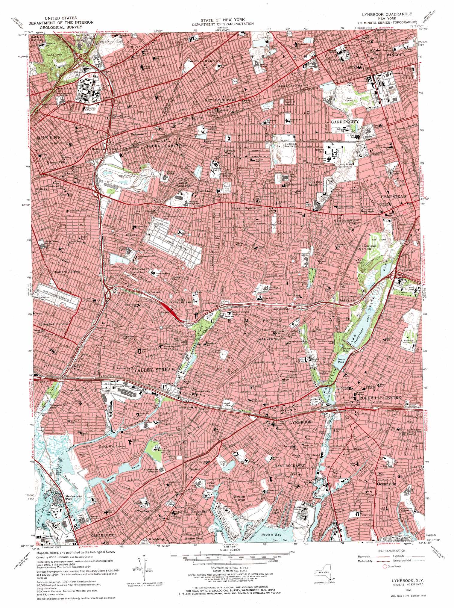
USGS Topo Quad 40073f6 - 1:24,000 scale
| Topo Map Name: | Lynbrook |
| USGS Topo Quad ID: | 40073f6 |
| Print Size: | ca. 21 1/4" wide x 27" high |
| Southeast Coordinates: | 40.625° N latitude / 73.625° W longitude |
| Map Center Coordinates: | 40.6875° N latitude / 73.6875° W longitude |
| U.S. State: | NY |
| Filename: | o40073f6.jpg |
| Download Map JPG Image: | Lynbrook topo map 1:24,000 scale |
| Map Type: | Topographic |
| Topo Series: | 7.5´ |
| Map Scale: | 1:24,000 |
| Source of Map Images: | United States Geological Survey (USGS) |
| Alternate Map Versions: |
Lynbrook NY 1947 Download PDF Buy paper map Lynbrook NY 1954, updated 1957 Download PDF Buy paper map Lynbrook NY 1954, updated 1964 Download PDF Buy paper map Lynbrook NY 1969, updated 1972 Download PDF Buy paper map Lynbrook NY 1969, updated 1972 Download PDF Buy paper map Lynbrook NY 2010 Download PDF Buy paper map Lynbrook NY 2013 Download PDF Buy paper map Lynbrook NY 2016 Download PDF Buy paper map |
1:24,000 Topo Quads surrounding Lynbrook
Yonkers |
Mount Vernon |
Mamaroneck |
Bayville |
Lloyd Harbor |
Central Park |
Flushing |
Sea Cliff |
Hicksville |
Huntington |
Brooklyn |
Jamaica |
Lynbrook |
Freeport |
Amityville |
Coney Island |
Far Rockaway |
Lawrence |
Jones Inlet |
West Gilgo Beach |
> Back to 40073e1 at 1:100,000 scale
> Back to 40072a1 at 1:250,000 scale
> Back to U.S. Topo Maps home
Lynbrook topo map: Gazetteer
Lynbrook: Airports
Belmont Park Heliport elevation 21m 68′Curtiss Wright Airport (historical) elevation 2m 6′
Winthrop University Hospital Heliport elevation 33m 108′
Lynbrook: Bays
Hewlett Bay elevation 0m 0′Thurston Basin elevation -2m -7′
Lynbrook: Canals
Cauerbach Canal elevation 0m 0′Grand Canal elevation 0m 0′
Lynbrook: Capes
Hewlett Point elevation 0m 0′Norton Point elevation 1m 3′
Uncle Daniels Point elevation 1m 3′
Lynbrook: Channels
Georges Creek elevation 0m 0′Macy Channel elevation 0m 0′
Reed Channel elevation 0m 0′
Lynbrook: Crossings
Interchange 13 elevation 15m 49′Interchange 14 elevation 11m 36′
Interchange 15 elevation 7m 22′
Interchange 16 elevation 8m 26′
Interchange 17 elevation 10m 32′
Interchange 18 elevation 11m 36′
Interchange 19 elevation 50m 164′
Interchange 19 elevation 12m 39′
Interchange 20 elevation 48m 157′
Interchange 21 elevation 44m 144′
Interchange 22 elevation 53m 173′
Lynbrook: Lakes
Conselyeas Pond elevation 2m 6′Grant Pond elevation 2m 6′
Grant Pond elevation 2m 6′
Schodack Pond elevation 6m 19′
Smith Pond elevation 5m 16′
Willow Pond elevation 3m 9′
Lynbrook: Parks
Alley Park elevation 53m 173′Alley Park Athletic Field elevation 37m 121′
Averill Boulevard Park elevation 19m 62′
Bay Park elevation 5m 16′
Bellerose Playground elevation 30m 98′
Belmont Park elevation 22m 72′
Bligh Field elevation 3m 9′
Breininger Park elevation 27m 88′
Brook Road Park elevation 2m 6′
Brookville Park elevation 2m 6′
Campbell Park elevation 16m 52′
Delphin H Greene Playground elevation 13m 42′
Doxey Brook Park elevation 3m 9′
Dutch Broadway Park elevation 12m 39′
Echo Park elevation 12m 39′
Elmont Road Park elevation 11m 36′
Father Reilly Square elevation 25m 82′
Firemens Memorial Field elevation 9m 29′
Floral Park Playground elevation 28m 91′
Frederick Cabbell Park elevation 14m 45′
Grant Park elevation 4m 13′
Greis Park elevation 7m 22′
Halls Pond Park elevation 8m 26′
Hemlock Playground elevation 30m 98′
Hempstead Lake State Park elevation 10m 32′
Herricks Road Park elevation 30m 98′
Hewlett Point Park elevation 2m 6′
Hickey Field elevation 8m 26′
Hillside Park elevation 31m 101′
Hook Creek Ballfield elevation 5m 16′
Hook Creek Wildlife Sanctuary elevation 0m 0′
Laurelton Playground elevation 6m 19′
Lister Park elevation 3m 9′
Litchult Square elevation 22m 72′
Mentone Playground elevation 5m 16′
North Woodmere Park elevation 1m 3′
Pat Williams Playground elevation 19m 62′
Patrol Officer William T Gunn Junior Park elevation 30m 98′
Playground 80 elevation 34m 111′
Public School 147 Playground elevation 17m 55′
Queens Farm Park elevation 34m 111′
Queens Village Veterans Plaza elevation 27m 88′
Rath Park elevation 15m 49′
Stiles Athletic Field elevation 23m 75′
Sunrise Playground elevation 1m 3′
Tanglewood Preserve elevation 4m 13′
Tenney Park elevation 37m 121′
Tullamore Playground elevation 27m 88′
Valley Stream State Park elevation 5m 16′
Veterans Memorial Park elevation 9m 29′
Veterans Square elevation 7m 22′
Wayanda Park elevation 21m 68′
Wilson Park elevation 34m 111′
Lynbrook: Populated Places
Alden Manor elevation 11m 36′Bay Park elevation 3m 9′
Bellerose elevation 26m 85′
Bellerose Terrace elevation 23m 75′
Cambria Heights elevation 15m 49′
East Rockaway elevation 3m 9′
Elmont elevation 12m 39′
Floral Park elevation 27m 88′
Franklin Square elevation 20m 65′
Garden City elevation 27m 88′
Garden City Park elevation 32m 104′
Garden City South elevation 21m 68′
Glen Oaks elevation 36m 118′
Green Acres elevation 3m 9′
Hempstead Gardens elevation 18m 59′
Hewlett elevation 6m 19′
Hewlett Bay Park elevation 2m 6′
Hewlett Harbor elevation 3m 9′
Lakeview elevation 12m 39′
Lynbrook elevation 6m 19′
Malverne elevation 11m 36′
Malverne Park Oaks elevation 3m 9′
Meadowmere Park elevation 0m 0′
Mineola elevation 33m 108′
New Hyde Park elevation 32m 104′
North New Hyde Park elevation 35m 114′
North Valley Stream elevation 11m 36′
North Woodmere elevation 2m 6′
Oceanside elevation 3m 9′
Queens Village elevation 27m 88′
Rockville Centre elevation 9m 29′
Rosedale elevation 5m 16′
South Floral Park elevation 21m 68′
South Valley Stream elevation 2m 6′
Springfield Gardens elevation 9m 29′
Stewart Manor elevation 26m 85′
Surrey Estates elevation 54m 177′
Valley Stream elevation 5m 16′
West Hempstead elevation 20m 65′
Woodmere elevation 7m 22′
Lynbrook: Post Offices
Alden Manor Branch Elmont Post Office elevation 11m 36′Cambria Station Jamaica Post Office elevation 16m 52′
East Rockaway Post Office elevation 1m 3′
Elmont Post Office elevation 13m 42′
Floral Park Post Office elevation 27m 88′
Franklin Square Post Office elevation 17m 55′
Garden City Post Office elevation 27m 88′
Glen Oaks Station Floral Park Post Office elevation 33m 108′
Hempstead Post Office elevation 16m 52′
Hewlett Post Office elevation 8m 26′
Lynbrook Post Office elevation 6m 19′
Malverne Post Office elevation 11m 36′
Meachum Branch Elmont Post Office elevation 10m 32′
Mineola Post Office elevation 33m 108′
New Hyde Park Main Post Office elevation 30m 98′
Oceanside Post Office elevation 3m 9′
Rockville Centre Post Office elevation 7m 22′
Rosedale Station Jamaica Post Office elevation 4m 13′
Springfield Gardens Branch Jamaica Post Office elevation 9m 29′
Valley Stream Post Office elevation 6m 19′
West Hempstead Post Office elevation 18m 59′
Woodmere Post Office elevation 8m 26′
Lynbrook: Reservoirs
Hempstead Lake elevation 11m 36′Pines Pond (historical) elevation 2m 6′
South Pond elevation 5m 16′
Valley Stream Pond elevation 2m 6′
Watts Pond (historical) elevation 1m 3′
Lynbrook: Streams
Hook Creek elevation 3m 9′Mill River elevation 0m 0′
Motts Creek elevation 0m 0′
Powell Creek elevation 0m 0′
Schodack Brook elevation 7m 22′
Thixton Creek elevation 11m 36′
Valley Stream elevation 0m 0′
Lynbrook digital topo map on disk
Buy this Lynbrook topo map showing relief, roads, GPS coordinates and other geographical features, as a high-resolution digital map file on DVD:
Atlantic Coast (NY, NJ, PA, DE, MD, VA, NC)
Buy digital topo maps: Atlantic Coast (NY, NJ, PA, DE, MD, VA, NC)
 map DVD")