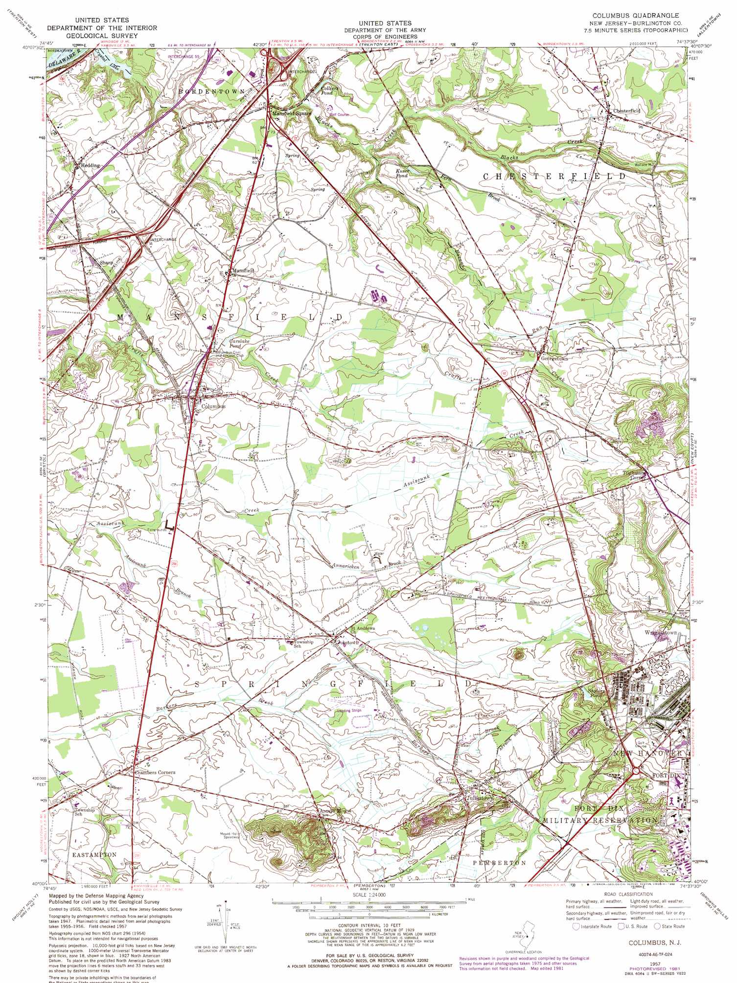
Columbus Topo Map New Jersey
To zoom in, hover over the map of Columbus
USGS Topo Quad 40074a6 - 1:24,000 scale
| Topo Map Name: | Columbus |
| USGS Topo Quad ID: | 40074a6 |
| Print Size: | ca. 21 1/4" wide x 27" high |
| Southeast Coordinates: | 40° N latitude / 74.625° W longitude |
| Map Center Coordinates: | 40.0625° N latitude / 74.6875° W longitude |
| U.S. State: | NJ |
| Filename: | o40074a6.jpg |
| Download Map JPG Image: | Columbus topo map 1:24,000 scale |
| Map Type: | Topographic |
| Topo Series: | 7.5´ |
| Map Scale: | 1:24,000 |
| Source of Map Images: | United States Geological Survey (USGS) |
| Alternate Map Versions: |
Columbus NJ 1948 Download PDF Buy paper map Columbus NJ 1948 Download PDF Buy paper map Columbus NJ 1957, updated 1961 Download PDF Buy paper map Columbus NJ 1957, updated 1971 Download PDF Buy paper map Columbus NJ 1957, updated 1982 Download PDF Buy paper map Columbus NJ 1957, updated 1988 Download PDF Buy paper map Columbus NJ 1957, updated 1988 Download PDF Buy paper map Columbus NJ 2011 Download PDF Buy paper map Columbus NJ 2014 Download PDF Buy paper map Columbus NJ 2016 Download PDF Buy paper map |
1:24,000 Topo Quads surrounding Columbus
Lambertville |
Pennington |
Princeton |
Hightstown |
Jamesburg |
Langhorne |
Trenton West |
Trenton East |
Allentown |
Roosevelt |
Beverly |
Bristol |
Columbus |
New Egypt |
Cassville |
Moorestown |
Mount Holly |
Pemberton |
Browns Mills |
Whiting |
Clementon |
Medford Lakes |
Indian Mills |
Chatsworth |
Woodmansie |
> Back to 40074a1 at 1:100,000 scale
> Back to 40074a1 at 1:250,000 scale
> Back to U.S. Topo Maps home
Columbus topo map: Gazetteer
Columbus: Airports
Redwing Airport elevation 22m 72′Columbus: Dams
Wallace Mill Dam elevation 21m 68′Columbus: Populated Places
Arneys Mount elevation 40m 131′Chambers Corners elevation 21m 68′
Chesterfield elevation 27m 88′
Columbus elevation 24m 78′
Folwell elevation 24m 78′
Georgetown elevation 29m 95′
Hedding elevation 25m 82′
Jobstown elevation 22m 72′
Juliustown elevation 31m 101′
Lewistown elevation 25m 82′
Mansfield elevation 27m 88′
Mansfield Square elevation 21m 68′
Pine Lane elevation 24m 78′
Sharp elevation 18m 59′
Springfield elevation 36m 118′
Tilghmans Corner elevation 57m 187′
Wallace Mill elevation 21m 68′
Columbus: Reservoirs
Carslake Pond elevation 14m 45′Colliers Pond elevation 13m 42′
Kuser Pond elevation 18m 59′
Saylors Pond elevation 39m 127′
Wallace Mill Pond elevation 21m 68′
Columbus: Streams
Annaricken Brook elevation 15m 49′Assiscunk Branch elevation 8m 26′
Bacons Run elevation 9m 29′
Fern Brook elevation 14m 45′
Columbus: Summits
Mount Pisgah elevation 55m 180′Columbus digital topo map on disk
Buy this Columbus topo map showing relief, roads, GPS coordinates and other geographical features, as a high-resolution digital map file on DVD:
Atlantic Coast (NY, NJ, PA, DE, MD, VA, NC)
Buy digital topo maps: Atlantic Coast (NY, NJ, PA, DE, MD, VA, NC)
 map DVD")