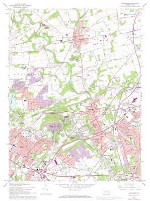
Langhorne Topo Map Pennsylvania
To zoom in, hover over the map of Langhorne
USGS Topo Quad 40074b8 - 1:24,000 scale
| Topo Map Name: | Langhorne |
| USGS Topo Quad ID: | 40074b8 |
| Print Size: | ca. 21 1/4" wide x 27" high |
| Southeast Coordinates: | 40.125° N latitude / 74.875° W longitude |
| Map Center Coordinates: | 40.1875° N latitude / 74.9375° W longitude |
| U.S. State: | PA |
| Filename: | o40074b8.jpg |
| Download Map JPG Image: | Langhorne topo map 1:24,000 scale |
| Map Type: | Topographic |
| Topo Series: | 7.5´ |
| Map Scale: | 1:24,000 |
| Source of Map Images: | United States Geological Survey (USGS) |
| Alternate Map Versions: |
Langhorne PA 1944, updated 1947 Download PDF Buy paper map Langhorne PA 1947, updated 1947 Download PDF Buy paper map Langhorne PA 1953, updated 1955 Download PDF Buy paper map Langhorne PA 1953, updated 1962 Download PDF Buy paper map Langhorne PA 1966, updated 1968 Download PDF Buy paper map Langhorne PA 1966, updated 1974 Download PDF Buy paper map Langhorne PA 1993, updated 1998 Download PDF Buy paper map Langhorne PA 2010 Download PDF Buy paper map Langhorne PA 2013 Download PDF Buy paper map Langhorne PA 2016 Download PDF Buy paper map |
1:24,000 Topo Quads surrounding Langhorne
> Back to 40074a1 at 1:100,000 scale
> Back to 40074a1 at 1:250,000 scale
> Back to U.S. Topo Maps home
Langhorne topo map: Gazetteer
Langhorne: Airports
Buehl Field elevation 48m 157′Giles and Ransome Airport elevation 30m 98′
Stott Airport elevation 38m 124′
Langhorne: Bridges
Schoefield Ford Covered Bridge elevation 23m 75′Scholfield Covered Bridge elevation 25m 82′
Langhorne: Crossings
Interchange 351 elevation 54m 177′Interchange 44 elevation 29m 95′
Interchange 46A elevation 59m 193′
Interchange 46B elevation 56m 183′
Interchange 49 elevation 55m 180′
Pennsylvania Turnpike Interchange 28 elevation 54m 177′
Langhorne: Dams
Bergen Dam elevation 42m 137′Core Creek Dam elevation 45m 147′
Finney Dam elevation 24m 78′
Hulmeville Dam elevation 4m 13′
Ironworks Dam elevation 37m 121′
Lower Dam elevation 22m 72′
Newtown Dam elevation 68m 223′
Philadelphia Suburban Dam elevation 34m 111′
Spring Garden Dam elevation 24m 78′
Upper Dam elevation 47m 154′
Langhorne: Lakes
Lake Luxembourg elevation 27m 88′Silver Lake elevation 42m 137′
Langhorne: Parks
Churchville County Park elevation 41m 134′Concord Park elevation 44m 144′
Core Creek County Park elevation 48m 157′
Foster Hollow County Park elevation 19m 62′
Liconia Park elevation 41m 134′
Mill Creek Valley Park elevation 19m 62′
Playwicki Park elevation 12m 39′
Tyler State Park elevation 72m 236′
Langhorne: Populated Places
Bridgetown elevation 47m 154′Bridgetown elevation 32m 104′
Bucktoe elevation 46m 150′
Calico Corner elevation 49m 160′
Edgeboro elevation 72m 236′
Elmwood Terrace elevation 30m 98′
Fairless Junction elevation 41m 134′
Glenlake elevation 57m 187′
Hellings Corner elevation 31m 101′
Holland elevation 51m 167′
Hulmeville elevation 14m 45′
Hulmeville Terrace elevation 16m 52′
Idlewood elevation 21m 68′
Janney elevation 43m 141′
La Trappe elevation 49m 160′
Langhorne elevation 67m 219′
Langhorne Gardens elevation 58m 190′
Langhorne Manor elevation 66m 216′
Langhorne Terrace elevation 41m 134′
Linconia elevation 45m 147′
Maple Point elevation 48m 157′
Midway elevation 24m 78′
Neshaminy (historical) elevation 32m 104′
Neshaminy Falls elevation 43m 141′
Neshaminy Heights elevation 19m 62′
Neshaminy Hills elevation 39m 127′
Neshaminy Woods elevation 53m 173′
Newtown elevation 48m 157′
Oakford elevation 54m 177′
Parkland elevation 54m 177′
Parkland Heights elevation 53m 173′
Penndel elevation 31m 101′
Saint Leonard elevation 41m 134′
Siles elevation 65m 213′
Trevose elevation 39m 127′
Trevose Heights elevation 54m 177′
Village Shires elevation 49m 160′
Villas of Middletown elevation 29m 95′
Woodbourne elevation 53m 173′
Woodside elevation 49m 160′
Langhorne: Post Offices
Eden Post Office (historical) elevation 32m 104′Feasterville Post Office elevation 55m 180′
Holland Post Office (historical) elevation 29m 95′
Langhorne: Reservoirs
Core Creek Reservoir elevation 45m 147′Hulmesville Lake elevation 4m 13′
Lake Neshaminy elevation 24m 78′
Springfield Lake elevation 37m 121′
Suburban Lake elevation 34m 111′
Langhorne: Streams
Core Creek elevation 16m 52′Ironworks Creek elevation 24m 78′
Mill Creek elevation 10m 32′
Newtown Creek elevation 18m 59′
Pine Run elevation 18m 59′
Langhorne digital topo map on disk
Buy this Langhorne topo map showing relief, roads, GPS coordinates and other geographical features, as a high-resolution digital map file on DVD:
Atlantic Coast (NY, NJ, PA, DE, MD, VA, NC)
Buy digital topo maps: Atlantic Coast (NY, NJ, PA, DE, MD, VA, NC)


