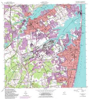
Long Branch Topo Map New Jersey
To zoom in, hover over the map of Long Branch
USGS Topo Quad 40074c1 - 1:24,000 scale
| Topo Map Name: | Long Branch |
| USGS Topo Quad ID: | 40074c1 |
| Print Size: | ca. 21 1/4" wide x 27" high |
| Southeast Coordinates: | 40.25° N latitude / 74° W longitude |
| Map Center Coordinates: | 40.3125° N latitude / 74.0625° W longitude |
| U.S. State: | NJ |
| Filename: | o40074c1.jpg |
| Download Map JPG Image: | Long Branch topo map 1:24,000 scale |
| Map Type: | Topographic |
| Topo Series: | 7.5´ |
| Map Scale: | 1:24,000 |
| Source of Map Images: | United States Geological Survey (USGS) |
| Alternate Map Versions: |
Long Branch West NJ 2011 Download PDF Buy paper map Long Branch West NJ 2014 Download PDF Buy paper map Long Branch West NJ 2016 Download PDF Buy paper map |
1:24,000 Topo Quads surrounding Long Branch
Perth Amboy |
Arthur Kill |
The Narrows |
Coney Island |
Far Rockaway |
South Amboy |
Keyport |
Sandy Hook |
||
Freehold |
Marlboro |
Long Branch |
||
Adelphia |
Farmingdale |
Asbury Park |
||
Lakehurst |
Lakewood |
Point Pleasant |
> Back to 40074a1 at 1:100,000 scale
> Back to 40074a1 at 1:250,000 scale
> Back to U.S. Topo Maps home
Long Branch topo map: Gazetteer
Long Branch: Airports
185 Monmouth Parkway Associates Helistop elevation 6m 19′Alexanders-Eatontown elevation 32m 104′
Charles Wood Helipad elevation 13m 42′
Due Process Stables Heliport elevation 20m 65′
E A I Landing Strip elevation 6m 19′
Greely Helipad elevation 5m 16′
Highlands Seaplane Base elevation 6m 19′
Marine Park elevation 12m 39′
Mosquito Commission Headquarters Heliport elevation 23m 75′
Red Bank Airport (historical) elevation 19m 62′
Long Branch: Bays
Blackberry Bay elevation 0m 0′Blossom Cove elevation 0m 0′
Long Branch: Bridges
Coopers Bridge elevation 0m 0′Hubbards Bridge elevation 0m 0′
Long Branch: Capes
Gooseneck Point elevation 0m 0′Guyon Point elevation 20m 65′
Horseneck Point elevation 0m 0′
Jones Point elevation 0m 0′
Lewis Point elevation 0m 0′
Rumson Neck elevation 17m 55′
Long Branch: Channels
Fair Haven Reach elevation 0m 0′Red Bank Reach elevation 0m 0′
Long Branch: Crossings
Interchange Number 105 elevation 18m 59′Interchange Number 109 elevation 18m 59′
Long Branch: Dams
Eatontown Dam elevation 6m 19′Franklin Lake Dam elevation 0m 0′
Poricy Dam elevation 6m 19′
Shadow Lake Dam elevation 0m 0′
Swimming River Reservoir Dam elevation 7m 22′
Long Branch: Guts
Town Neck Creek elevation 2m 6′Long Branch: Parks
Blackberry Bay Park elevation 5m 16′Bodman Park elevation 17m 55′
Branchport Park elevation 3m 9′
Joe Palaia Park elevation 11m 36′
John Parker Park elevation 8m 26′
Lincroft Park elevation 17m 55′
Manson Park elevation 13m 42′
Marine Park elevation 5m 16′
Monmouth Race Track elevation 6m 19′
Normandy Park elevation 15m 49′
Poricy Park elevation 13m 42′
Stevenson Park elevation 14m 45′
Swimming River Natural Area elevation 5m 16′
Weltz Park elevation 12m 39′
Wolf Hill Recreation Area elevation 10m 32′
Long Branch: Populated Places
Cooks Mills elevation 20m 65′Deal Park elevation 5m 16′
Dogs Corners elevation 16m 52′
Eatontown elevation 18m 59′
Elberon Park elevation 12m 39′
Fair Haven elevation 9m 29′
Fairview elevation 33m 108′
Lincroft elevation 23m 75′
Little Silver elevation 9m 29′
Little Silver Point elevation 4m 13′
Macedonia elevation 25m 82′
Oakhurst elevation 13m 42′
Oakhurst Manor elevation 11m 36′
Oceanport elevation 6m 19′
Pine Brook elevation 36m 118′
Port-au-Peck elevation 6m 19′
Red Bank elevation 14m 45′
Sands Point elevation 5m 16′
Shrewsbury elevation 11m 36′
Tinton Falls elevation 12m 39′
Wayside elevation 39m 127′
Wertheins Corner elevation 19m 62′
West Long Branch elevation 9m 29′
West Shrewsbury elevation 18m 59′
Wileys Corners elevation 41m 134′
Long Branch: Reservoirs
Franklin Lake elevation 0m 0′Marion Lake elevation 6m 19′
Mohawk Pond elevation 11m 36′
Poricy Pond elevation 6m 19′
Shadow Lake elevation 0m 0′
Shippees Pond elevation 6m 19′
Simmons Pond elevation 12m 39′
Swimming River Reservoir elevation 7m 22′
Long Branch: Streams
Cranberry Brook elevation 13m 42′Fourth Creek elevation 6m 19′
Hockhockson Brook elevation 12m 39′
Husky Brook elevation 3m 9′
Little Silver Creek elevation 0m 0′
McClees Creek elevation 0m 0′
Nut Swamp Brook elevation 0m 0′
Oceanport Creek elevation 0m 0′
Parkers Creek elevation 0m 0′
Parkers Creek Branch elevation 4m 13′
Pine Brook elevation 0m 0′
Poricy Brook elevation 0m 0′
Swimming River elevation 0m 0′
Turtle Mill Brook elevation 6m 19′
Wampum Brook elevation 4m 13′
Long Branch digital topo map on disk
Buy this Long Branch topo map showing relief, roads, GPS coordinates and other geographical features, as a high-resolution digital map file on DVD:
Atlantic Coast (NY, NJ, PA, DE, MD, VA, NC)
Buy digital topo maps: Atlantic Coast (NY, NJ, PA, DE, MD, VA, NC)


