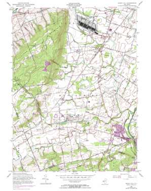
Rocky Hill Topo Map New Jersey
To zoom in, hover over the map of Rocky Hill
USGS Topo Quad 40074d6 - 1:24,000 scale
| Topo Map Name: | Rocky Hill |
| USGS Topo Quad ID: | 40074d6 |
| Print Size: | ca. 21 1/4" wide x 27" high |
| Southeast Coordinates: | 40.375° N latitude / 74.625° W longitude |
| Map Center Coordinates: | 40.4375° N latitude / 74.6875° W longitude |
| U.S. State: | NJ |
| Filename: | o40074d6.jpg |
| Download Map JPG Image: | Rocky Hill topo map 1:24,000 scale |
| Map Type: | Topographic |
| Topo Series: | 7.5´ |
| Map Scale: | 1:24,000 |
| Source of Map Images: | United States Geological Survey (USGS) |
| Alternate Map Versions: |
Rocky Hill NJ 1954, updated 1956 Download PDF Buy paper map Rocky Hill NJ 1954, updated 1964 Download PDF Buy paper map Rocky Hill NJ 1954, updated 1972 Download PDF Buy paper map Rocky Hill NJ 1954, updated 1972 Download PDF Buy paper map Rocky Hill NJ 1995, updated 2000 Download PDF Buy paper map Rocky Hill NJ 2011 Download PDF Buy paper map Rocky Hill NJ 2014 Download PDF Buy paper map Rocky Hill NJ 2016 Download PDF Buy paper map |
1:24,000 Topo Quads surrounding Rocky Hill
> Back to 40074a1 at 1:100,000 scale
> Back to 40074a1 at 1:250,000 scale
> Back to U.S. Topo Maps home
Rocky Hill topo map: Gazetteer
Rocky Hill: Airports
Osterman Heliport elevation 64m 209′Princeton Airport elevation 36m 118′
Rocky Hill: Canals
Delaware and Raritan Canal elevation 11m 36′Rocky Hill: Dams
Skillman Dam elevation 26m 85′Rocky Hill: Parks
Autumn Hill Park elevation 81m 265′Delaware and Raritan State Park elevation 12m 39′
Herrontown Woods Arboretum elevation 83m 272′
Montgomery Park elevation 22m 72′
Sourland Mountain County Preserve elevation 109m 357′
Rocky Hill: Populated Places
Belle Mead elevation 30m 98′Blawenburg elevation 48m 157′
Bloomingdale elevation 24m 78′
Bridgepoint elevation 26m 85′
Dutchtown elevation 36m 118′
Fairview elevation 79m 259′
Harlingen elevation 27m 88′
Hillsborough elevation 26m 85′
Neshanic elevation 42m 137′
Plainville elevation 34m 111′
Pleasantview elevation 31m 101′
Rock Mill elevation 118m 387′
Rocky Hill elevation 26m 85′
Skillman elevation 38m 124′
Stoutsburg elevation 50m 164′
Zion elevation 109m 357′
Rocky Hill: Reservoirs
Bridgepoint Lake elevation 12m 39′Sylvan Lake elevation 26m 85′
Rocky Hill: Streams
Back Brook elevation 17m 55′Beden Brook elevation 12m 39′
Cat Tail Brook elevation 67m 219′
Cruser Brook elevation 16m 52′
Dead Tree Run elevation 13m 42′
Fox Brook elevation 23m 75′
Pike Run elevation 13m 42′
Pine Tree Run elevation 12m 39′
Roaring Brook elevation 30m 98′
Rock Brook elevation 16m 52′
Van Horn Brook elevation 12m 39′
Rocky Hill: Summits
Pheasant Hill elevation 134m 439′Rocky Hill elevation 92m 301′
Sourland Mountain elevation 171m 561′
Rocky Hill digital topo map on disk
Buy this Rocky Hill topo map showing relief, roads, GPS coordinates and other geographical features, as a high-resolution digital map file on DVD:
Atlantic Coast (NY, NJ, PA, DE, MD, VA, NC)
Buy digital topo maps: Atlantic Coast (NY, NJ, PA, DE, MD, VA, NC)


