Hopewell Topo Map New Jersey
To zoom in, hover over the map of Hopewell
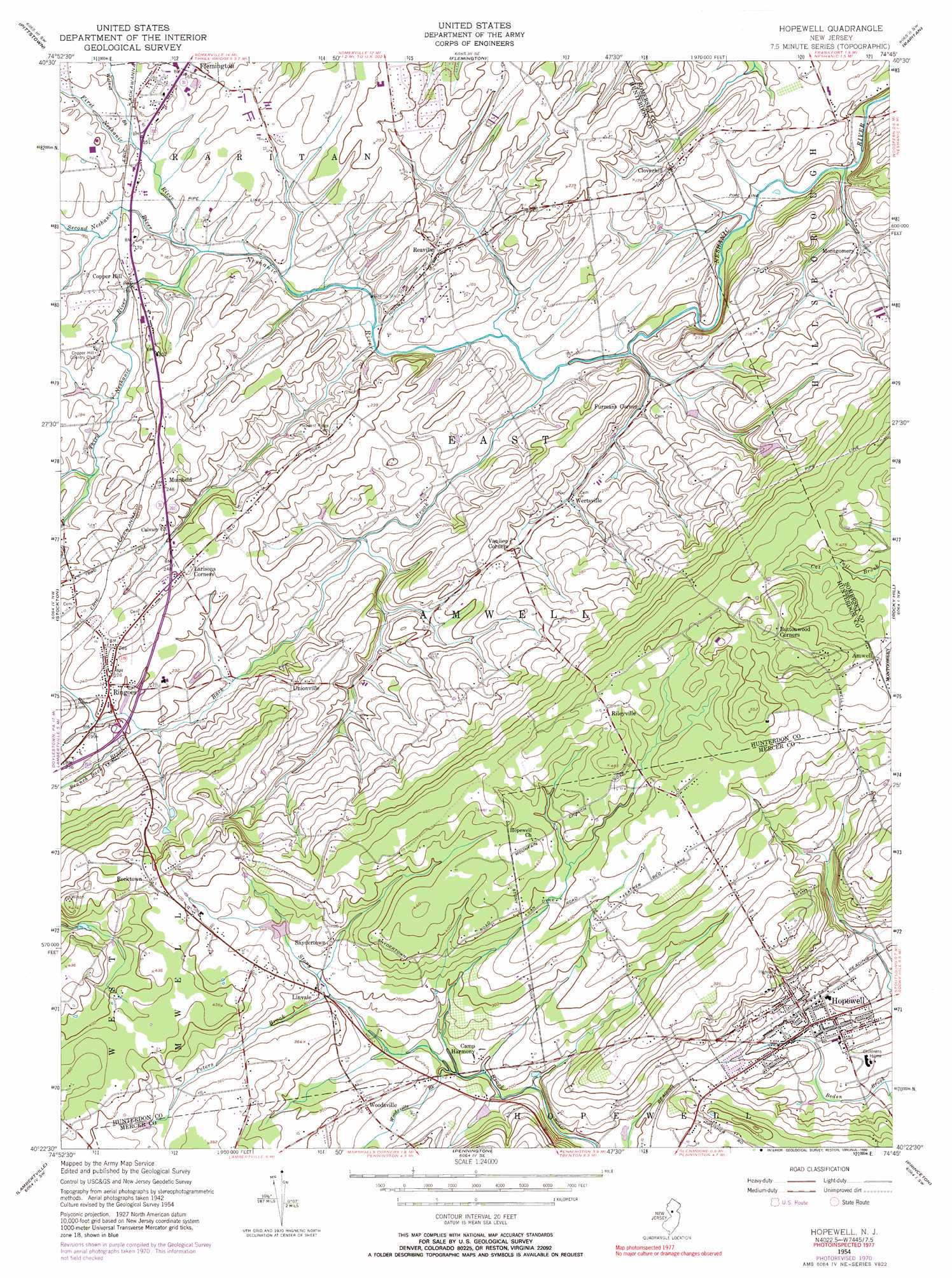
USGS Topo Quad 40074d7 - 1:24,000 scale
| Topo Map Name: | Hopewell |
| USGS Topo Quad ID: | 40074d7 |
| Print Size: | ca. 21 1/4" wide x 27" high |
| Southeast Coordinates: | 40.375° N latitude / 74.75° W longitude |
| Map Center Coordinates: | 40.4375° N latitude / 74.8125° W longitude |
| U.S. State: | NJ |
| Filename: | o40074d7.jpg |
| Download Map JPG Image: | Hopewell topo map 1:24,000 scale |
| Map Type: | Topographic |
| Topo Series: | 7.5´ |
| Map Scale: | 1:24,000 |
| Source of Map Images: | United States Geological Survey (USGS) |
| Alternate Map Versions: |
Hopewell NJ 1954, updated 1955 Download PDF Buy paper map Hopewell NJ 1954, updated 1963 Download PDF Buy paper map Hopewell NJ 1954, updated 1972 Download PDF Buy paper map Hopewell NJ 1954, updated 1990 Download PDF Buy paper map Hopewell NJ 2011 Download PDF Buy paper map Hopewell NJ 2014 Download PDF Buy paper map Hopewell NJ 2016 Download PDF Buy paper map |
1:24,000 Topo Quads surrounding Hopewell
Bloomsbury |
High Bridge |
Califon |
Gladstone |
Bernardsville |
Frenchtown |
Pittstown |
Flemington |
Raritan |
Bound Brook |
Lumberville |
Stockton |
Hopewell |
Rocky Hill |
Monmouth Junction |
Buckingham |
Lambertville |
Pennington |
Princeton |
Hightstown |
Hatboro |
Langhorne |
Trenton West |
Trenton East |
Allentown |
> Back to 40074a1 at 1:100,000 scale
> Back to 40074a1 at 1:250,000 scale
> Back to U.S. Topo Maps home
Hopewell topo map: Gazetteer
Hopewell: Airports
Hillside Farm Heliport elevation 118m 387′O'Dwyer Airport elevation 49m 160′
Thompson Landing elevation 81m 265′
Hopewell: Parks
Amwell Lake Wildlife Management Area elevation 98m 321′Hopewell Boro Park elevation 49m 160′
Hopewell: Populated Places
Amwell elevation 139m 456′Cloverhill elevation 56m 183′
Copper Hill elevation 45m 147′
Furmans Corner elevation 43m 141′
Hopewell elevation 60m 196′
Larisons Corners elevation 78m 255′
Linvale elevation 91m 298′
Montgomery elevation 38m 124′
Muirhead elevation 75m 246′
Reaville elevation 55m 180′
Rileyville elevation 145m 475′
Ringoes elevation 67m 219′
Rocktown elevation 127m 416′
Snydertown elevation 98m 321′
Unionville elevation 70m 229′
Wertsville elevation 50m 164′
Woodsville elevation 82m 269′
Hopewell: Reservoirs
Hunt Lake elevation 65m 213′Hopewell: Streams
Back Brook elevation 31m 101′Branch Back Brook elevation 55m 180′
First Neshanic River elevation 41m 134′
Peters Brook elevation 85m 278′
Second Neshanic River elevation 41m 134′
Third Neshanic River elevation 41m 134′
Walnut Brook elevation 47m 154′
Woodsville Brook elevation 60m 196′
Hopewell digital topo map on disk
Buy this Hopewell topo map showing relief, roads, GPS coordinates and other geographical features, as a high-resolution digital map file on DVD:
Atlantic Coast (NY, NJ, PA, DE, MD, VA, NC)
Buy digital topo maps: Atlantic Coast (NY, NJ, PA, DE, MD, VA, NC)
 map DVD")