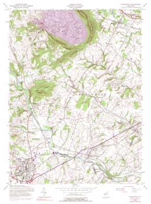
Flemington Topo Map New Jersey
To zoom in, hover over the map of Flemington
USGS Topo Quad 40074e7 - 1:24,000 scale
| Topo Map Name: | Flemington |
| USGS Topo Quad ID: | 40074e7 |
| Print Size: | ca. 21 1/4" wide x 27" high |
| Southeast Coordinates: | 40.5° N latitude / 74.75° W longitude |
| Map Center Coordinates: | 40.5625° N latitude / 74.8125° W longitude |
| U.S. State: | NJ |
| Filename: | o40074e7.jpg |
| Download Map JPG Image: | Flemington topo map 1:24,000 scale |
| Map Type: | Topographic |
| Topo Series: | 7.5´ |
| Map Scale: | 1:24,000 |
| Source of Map Images: | United States Geological Survey (USGS) |
| Alternate Map Versions: |
Flemington NJ 1954, updated 1956 Download PDF Buy paper map Flemington NJ 1954, updated 1964 Download PDF Buy paper map Flemington NJ 1954, updated 1972 Download PDF Buy paper map Flemington NJ 1954, updated 1979 Download PDF Buy paper map Flemington NJ 2011 Download PDF Buy paper map Flemington NJ 2014 Download PDF Buy paper map Flemington NJ 2016 Download PDF Buy paper map |
1:24,000 Topo Quads surrounding Flemington
> Back to 40074e1 at 1:100,000 scale
> Back to 40074a1 at 1:250,000 scale
> Back to U.S. Topo Maps home
Flemington topo map: Gazetteer
Flemington: Airports
Herr Mountain Airport elevation 169m 554′Hunterdon Medical Center Heliport elevation 58m 190′
Lance Airport elevation 79m 259′
Flemington: Dams
Rockefellows Mills Dam elevation 30m 98′Round Valley South Dam elevation 73m 239′
Flemington: Islands
Packers Island elevation 38m 124′Flemington: Parks
Round Valley State Recreation Area elevation 116m 380′Flemington: Populated Places
Bartles Corners elevation 57m 187′Centerville elevation 30m 98′
Cushetunk elevation 64m 209′
Darts Mills elevation 42m 137′
Dreahook elevation 69m 226′
Flemington elevation 53m 173′
Flemington Junction elevation 39m 127′
Higginsville elevation 29m 95′
Holcomb Mills elevation 37m 121′
McPherson elevation 74m 242′
Pleasant Run elevation 42m 137′
Riverside elevation 26m 85′
Rockefellows Mills elevation 36m 118′
Rowland Mills elevation 44m 144′
Stanton elevation 110m 360′
Three Bridges elevation 37m 121′
Voorhees Corner elevation 62m 203′
Whitehouse Station elevation 55m 180′
Woodfern elevation 26m 85′
Flemington: Post Offices
Flemington Post Office elevation 53m 173′Flemington: Reservoirs
Cushetunk Lake elevation 41m 134′Red Rock Lake elevation 30m 98′
Round Valley Reservoir elevation 116m 380′
Flemington: Streams
Assiscong Creek elevation 36m 118′Bushkill Brook elevation 34m 111′
Minneakoning Creek elevation 35m 114′
Prescott Brook elevation 38m 124′
Flemington: Summits
Cushetunk Mountain elevation 252m 826′Round Mountain elevation 186m 610′
Flemington digital topo map on disk
Buy this Flemington topo map showing relief, roads, GPS coordinates and other geographical features, as a high-resolution digital map file on DVD:
Atlantic Coast (NY, NJ, PA, DE, MD, VA, NC)
Buy digital topo maps: Atlantic Coast (NY, NJ, PA, DE, MD, VA, NC)


