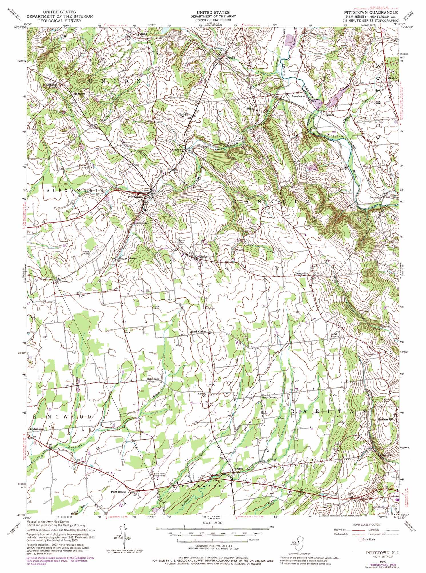
Pittstown Topo Map New Jersey
To zoom in, hover over the map of Pittstown
USGS Topo Quad 40074e8 - 1:24,000 scale
| Topo Map Name: | Pittstown |
| USGS Topo Quad ID: | 40074e8 |
| Print Size: | ca. 21 1/4" wide x 27" high |
| Southeast Coordinates: | 40.5° N latitude / 74.875° W longitude |
| Map Center Coordinates: | 40.5625° N latitude / 74.9375° W longitude |
| U.S. State: | NJ |
| Filename: | o40074e8.jpg |
| Download Map JPG Image: | Pittstown topo map 1:24,000 scale |
| Map Type: | Topographic |
| Topo Series: | 7.5´ |
| Map Scale: | 1:24,000 |
| Source of Map Images: | United States Geological Survey (USGS) |
| Alternate Map Versions: |
Cakepoulin Creek NJ 1952 Download PDF Buy paper map Pittstown NJ 1952 Download PDF Buy paper map Pittstown NJ 1955, updated 1956 Download PDF Buy paper map Pittstown NJ 1955, updated 1960 Download PDF Buy paper map Pittstown NJ 1955, updated 1969 Download PDF Buy paper map Pittstown NJ 1955, updated 1972 Download PDF Buy paper map Pittstown NJ 1955, updated 1988 Download PDF Buy paper map Pittstown NJ 1955, updated 1988 Download PDF Buy paper map Pittstown NJ 2011 Download PDF Buy paper map Pittstown NJ 2014 Download PDF Buy paper map Pittstown NJ 2016 Download PDF Buy paper map |
1:24,000 Topo Quads surrounding Pittstown
Bangor |
Belvidere |
Washington |
Hackettstown |
Chester |
Easton |
Bloomsbury |
High Bridge |
Califon |
Gladstone |
Riegelsville |
Frenchtown |
Pittstown |
Flemington |
Raritan |
Bedminster |
Lumberville |
Stockton |
Hopewell |
Rocky Hill |
Doylestown |
Buckingham |
Lambertville |
Pennington |
Princeton |
> Back to 40074e1 at 1:100,000 scale
> Back to 40074a1 at 1:250,000 scale
> Back to U.S. Topo Maps home
Pittstown topo map: Gazetteer
Pittstown: Airports
Bradford Field elevation 159m 521′Copper Penny elevation 135m 442′
Formica elevation 149m 488′
Mock Airport elevation 174m 570′
Sky Manor Airport elevation 172m 564′
Teeny Weeny Acres Airport elevation 84m 275′
Pittstown: Lakes
Echo Lake (historical) elevation 34m 111′Pittstown: Parks
Capoolong Wildlife Management Area elevation 79m 259′Pittstown: Populated Places
Allens Corner elevation 198m 649′Allerton elevation 76m 249′
Alvater Corner elevation 141m 462′
Cherryville elevation 207m 679′
Croton elevation 157m 515′
Gary Corner elevation 174m 570′
Grandin elevation 81m 265′
Hamden elevation 52m 170′
Jutland elevation 104m 341′
Kingtown elevation 91m 298′
Klinesville elevation 157m 515′
Lansdowne elevation 53m 173′
Littletown elevation 127m 416′
Mechlings Corner elevation 213m 698′
Mount Salem elevation 209m 685′
Oak Grove elevation 163m 534′
Pittstown elevation 116m 380′
Point Breeze elevation 169m 554′
Quakertown elevation 197m 646′
Sidney elevation 76m 249′
Sunnyside elevation 50m 164′
Thachers Hill elevation 159m 521′
Pittstown: Streams
Allerton Creek elevation 48m 157′Capoolong Creek elevation 53m 173′
Cramers Creek elevation 51m 167′
Pittstown digital topo map on disk
Buy this Pittstown topo map showing relief, roads, GPS coordinates and other geographical features, as a high-resolution digital map file on DVD:
Atlantic Coast (NY, NJ, PA, DE, MD, VA, NC)
Buy digital topo maps: Atlantic Coast (NY, NJ, PA, DE, MD, VA, NC)
 map DVD")