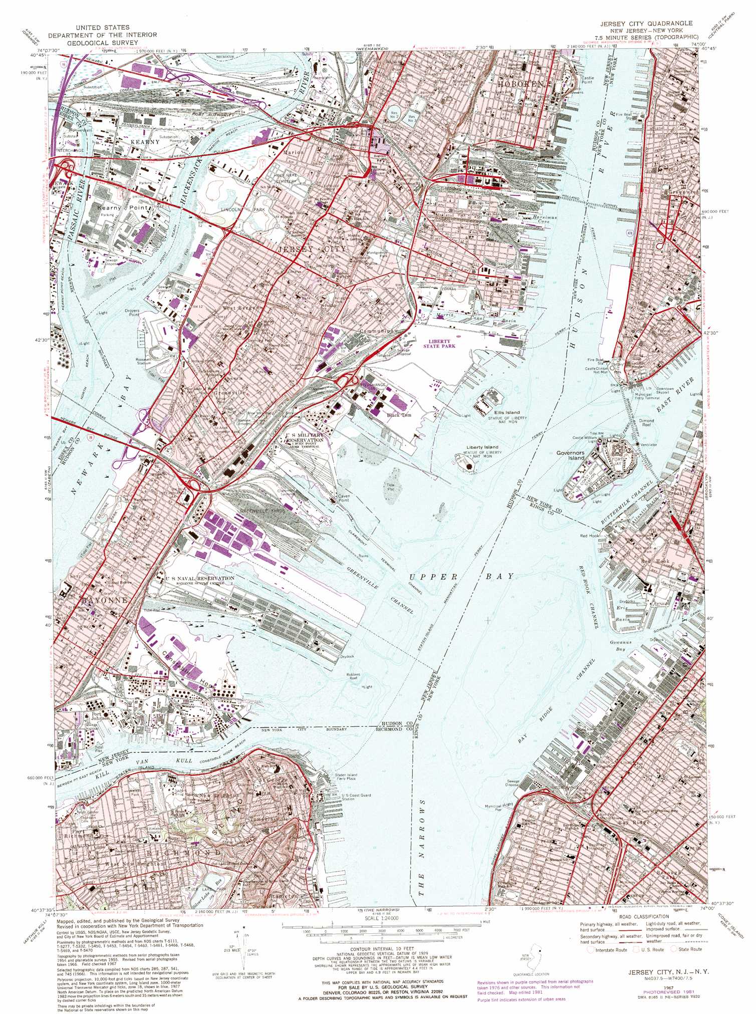
Jersey City Topo Map New Jersey
To zoom in, hover over the map of Jersey City
USGS Topo Quad 40074f1 - 1:24,000 scale
| Topo Map Name: | Jersey City |
| USGS Topo Quad ID: | 40074f1 |
| Print Size: | ca. 21 1/4" wide x 27" high |
| Southeast Coordinates: | 40.625° N latitude / 74° W longitude |
| Map Center Coordinates: | 40.6875° N latitude / 74.0625° W longitude |
| U.S. States: | NJ, NY |
| Filename: | o40074f1.jpg |
| Download Map JPG Image: | Jersey City topo map 1:24,000 scale |
| Map Type: | Topographic |
| Topo Series: | 7.5´ |
| Map Scale: | 1:24,000 |
| Source of Map Images: | United States Geological Survey (USGS) |
| Alternate Map Versions: |
Jersey City NJ 1947 Download PDF Buy paper map Jersey City NJ 1955, updated 1958 Download PDF Buy paper map Jersey City NJ 1955, updated 1964 Download PDF Buy paper map Jersey City NJ 1967, updated 1969 Download PDF Buy paper map Jersey City NJ 1967, updated 1982 Download PDF Buy paper map Jersey City NJ 1967, updated 1982 Download PDF Buy paper map Jersey City NJ 2011 Download PDF Buy paper map Jersey City NJ 2014 Download PDF Buy paper map Jersey City NJ 2016 Download PDF Buy paper map |
1:24,000 Topo Quads surrounding Jersey City
Pompton Plains |
Paterson |
Hackensack |
Yonkers |
Mount Vernon |
Caldwell |
Orange |
Weehawken |
Central Park |
Flushing |
Roselle |
Elizabeth |
Jersey City |
Brooklyn |
Jamaica |
Perth Amboy |
Arthur Kill |
The Narrows |
Coney Island |
Far Rockaway |
South Amboy |
Keyport |
Sandy Hook |
> Back to 40074e1 at 1:100,000 scale
> Back to 40074a1 at 1:250,000 scale
> Back to U.S. Topo Maps home
Jersey City topo map: Gazetteer
Jersey City: Airports
111 Wall Street Heliport elevation 1m 3′Caven Point USAR Center Heliport elevation 0m 0′
Colgate-Jersey City Heliport elevation 0m 0′
Essex Generating Station Heliport elevation 1m 3′
Jersey City Seaplane Base elevation 0m 0′
Kearny Helistop elevation 0m 0′
Liberty State Park Heliport elevation 0m 0′
Newport Helistop elevation 0m 0′
Port Authority-Downtown Manhattan-Wall Street Heliport elevation 0m 0′
Rollins Jersey City Helistop elevation 4m 13′
Jersey City: Bars
Bay Ridge Flats elevation 6m 19′Dimond Reef elevation 0m 0′
Gowanus Flats elevation 0m 0′
Jersey Flats elevation 0m 0′
Robbins Reef elevation 0m 0′
Jersey City: Basins
Morris Canal Basin elevation 0m 0′Jersey City: Bays
Gowanus Bay elevation 0m 0′Harsimus Cove elevation 0m 0′
South Cove elevation 0m 0′
Upper Bay elevation 0m 0′
Jersey City: Bridges
Lincoln Highway Bridge elevation 0m 0′Newark Bay Bridge elevation 0m 0′
Trinity Place Bridge elevation 8m 26′
Jersey City: Capes
Castle Point elevation 0m 0′Caven Point elevation 0m 0′
Constable Hook elevation 2m 6′
Droyers Point elevation 1m 3′
Ducksberry Point elevation 8m 26′
Kearny Point elevation 2m 6′
Point No Point elevation 0m 0′
Red Hook elevation 0m 0′
The Battery elevation 3m 9′
Jersey City: Channels
Anchorage Channel elevation 0m 0′Bay Ridge Channel elevation 0m 0′
Bergen Point East Reach elevation 0m 0′
Bergen Point East Reach elevation 0m 0′
Buttermilk Channel elevation 0m 0′
Claremont Terminal Channel elevation 0m 0′
Constable Hook Reach elevation 0m 0′
Constable Hook Reach elevation 0m 0′
Droyers Point Reach elevation 0m 0′
Greenville Channel elevation 0m 0′
Kearny Point Reach elevation 0m 0′
Marion Reach elevation 0m 0′
North Reach elevation 0m 0′
Pierhead Channel elevation 0m 0′
Point No Point Reach elevation 0m 0′
Red Hook Channel elevation 0m 0′
The Narrows elevation 0m 0′
Jersey City: Crossings
Dow's Ferry (historical) elevation 0m 0′Interchange 1 elevation 5m 16′
Interchange 14A elevation 13m 42′
Interchange 14B elevation 12m 39′
Interchange 14C elevation 5m 16′
Interchange 4 elevation 8m 26′
Staten Island Manhattan Ferry elevation 0m 0′
Jersey City: Dams
Rock Breakwater elevation 0m 0′Jersey City: Harbors
Atlantic Basin elevation 11m 36′Erie Basin elevation 0m 0′
Henry Street Basin elevation -5m -17′
North Cove Yacht Harbor elevation 0m 0′
Jersey City: Islands
Ellis Island elevation 2m 6′Governors Island elevation 2m 6′
Liberty Island elevation 2m 6′
Jersey City: Lakes
Collect Pond (historical) elevation 5m 16′Jersey City: Levees
Pier 7 elevation 0m 0′Jersey City: Parks
Abingdon Square elevation 6m 19′Admiral Triangle elevation 7m 22′
African Burial Ground National Monument elevation 8m 26′
Allison Park elevation 13m 42′
Arlington Park elevation 16m 52′
Audubon Park elevation 27m 88′
Austin J McDonald Playground elevation 38m 124′
Battery Park elevation 3m 9′
Bayside Park elevation 5m 16′
Bleecker Playground elevation 6m 19′
Bowling Green elevation 5m 16′
Boyd-McGuiness Park elevation 26m 85′
Canal Park elevation 2m 6′
Castle Clinton National Monument elevation 1m 3′
Castle Point Park elevation 0m 0′
Charlton Plaza elevation 7m 22′
Charlton-King-Vandam Historic District elevation 6m 19′
Chelsea Historic District elevation 4m 13′
Christopher Park elevation 6m 19′
Church Square elevation 3m 9′
City Hall Park elevation 11m 36′
Clement Clarke Moore Park elevation 3m 9′
Collect Pond Park elevation 5m 16′
Columbia Park elevation 18m 59′
Columbus Park elevation 2m 6′
Columbus Park elevation 2m 6′
Columbus Park elevation 5m 16′
Commons Historic District elevation 11m 36′
Cortney Fricchione Park elevation 5m 16′
Davis Playground elevation 26m 85′
Dimattina Playground elevation 9m 29′
Doctor Gertrude B Kelly Playground elevation 6m 19′
Downing Street Playground elevation 6m 19′
Drumgoole Plaza elevation 6m 19′
Duane Park elevation 5m 16′
Dustbowl elevation 28m 91′
East Coast Memorial elevation 2m 6′
Ellis Island National Monument (historical) elevation 2m 6′
Elysian Fields elevation 2m 6′
Elysian Park elevation 6m 19′
Father Demo Square elevation 6m 19′
Father Fagan Square elevation 6m 19′
Federal Hall National Memorial elevation 8m 26′
Fems Park elevation 23m 75′
Finn Square elevation 5m 16′
Fishbridge Gardens elevation 4m 13′
Foley Square elevation 6m 19′
Fort Hamilton Athletic Field elevation 9m 29′
Fort Hill Park elevation 52m 170′
Fraunces Tavern Block Historic District elevation 2m 6′
Fulton Avenue Park elevation 24m 78′
Golden Park elevation 40m 131′
Governor Nelson A Rockefeller Park elevation 0m 0′
Governors Island National Monument elevation 5m 16′
Grand Canal Court elevation 3m 9′
Hamilton Park elevation 6m 19′
Hanover Square elevation 3m 9′
Harold Ickes Playground elevation 3m 9′
Harvard Yard elevation 52m 170′
Haven Esplanade elevation 82m 269′
Hero Park elevation 77m 252′
Hudson Park elevation 5m 16′
Hudson Park elevation 9m 29′
Hudson River Waterfront Walkway elevation 3m 9′
Human Compass Garden elevation 5m 16′
Jackson Square elevation 7m 22′
James Madison Plaza elevation 5m 16′
Joe Holzka Community Garden elevation 9m 29′
John D'Emic Senior Memorial Park elevation 5m 16′
John F Kennedy Stadium elevation 2m 6′
John J DeLury Senior Plaza elevation 7m 22′
Jones Park elevation 3m 9′
Juan Pablo Duarte Square elevation 2m 6′
Lackawanna Park elevation 0m 0′
Lafayette Park elevation 3m 9′
LaPointe Park elevation 19m 62′
Lawrence C Thompson Memorial Park elevation 4m 13′
Leif Ericson Park And Square elevation 24m 78′
Liberty Plaza elevation 9m 29′
Liberty State Park elevation 1m 3′
Lincoln Park elevation 3m 9′
Liotti-Ikefugi Playground elevation 61m 200′
Little Red Square elevation 6m 19′
Louis Valentino Junior Park elevation 1m 3′
Louise Nevelson Plaza elevation 5m 16′
MacDougal-Sullivan Gardens Historic District elevation 7m 22′
Madison Park elevation 1m 3′
Mahoney Playground elevation 25m 82′
Major Barrett Triangle elevation 14m 45′
Martin Luther Playground elevation 12m 39′
Mary Benson Park elevation 7m 22′
McCarthy Square elevation 7m 22′
McGovern Park elevation 3m 9′
McKinley Park elevation 28m 91′
Meluso Park elevation 2m 6′
Mercer County Park elevation 10m 32′
Minetta Green elevation 6m 19′
Minetta Playground elevation 6m 19′
Minetta Triangle elevation 6m 19′
Montgomery Park elevation 3m 9′
Mother Cabrini Park elevation 3m 9′
Muhammad Ali Park elevation 24m 78′
Mulry Square elevation 8m 26′
New York Vietnam Veterans Memorial elevation 0m 0′
Nicholas Lia Memorial Park elevation 39m 127′
Nolan Park elevation 4m 13′
Owls Head Park elevation 21m 68′
Passannante Square elevation 6m 19′
Payne Park elevation 13m 42′
Pershing Field elevation 38m 124′
Pier A Park elevation 0m 0′
Pinocchio Playground elevation 13m 42′
Playground of the Americas elevation 6m 19′
Playground Three Forty elevation 9m 29′
Prall Playground elevation 32m 104′
Printing House Square elevation 10m 32′
Public School 1 Playground elevation 13m 42′
Public School 45 Playground elevation 54m 177′
Pumphouse Park elevation 0m 0′
Rainbow Playground elevation 40m 131′
Rector Park elevation 0m 0′
Red Hook Park elevation 3m 9′
Red Hook Recreational Area elevation 5m 16′
Richmond County Bank Ballpark at Saint George elevation 1m 3′
Riverview Park elevation 36m 118′
Robert F Wagner Junior Park elevation 0m 0′
Roller Rink Park elevation 1m 3′
Roosevelt Stadium (historical) elevation 3m 9′
Russell Pederson Playground elevation 11m 36′
Saint George - New Brighton Historic District elevation 26m 85′
Saint John's Park elevation 4m 13′
Seravalli Playground elevation 5m 16′
Sheridan Square elevation 6m 19′
Sheridan Square Triangle Association Viewing Garden elevation 6m 19′
Silver Lake Park elevation 66m 216′
Sinatra Park elevation 3m 9′
Skinner Park elevation 16m 52′
Skyline Playground elevation 59m 193′
SoHo Cast Iron Historic District elevation 6m 19′
Soho Square elevation 5m 16′
Sol Goldman Recreation Center and Pool elevation 6m 19′
South Cove Park elevation 0m 0′
South Street Seaport Historic District elevation 1m 3′
Statue of Liberty elevation 2m 6′
Statue of Liberty National Monument elevation 2m 6′
Stephen R Gregg Bayonne Park elevation 3m 9′
Stone Street Historic District elevation 3m 9′
Summit Street Community Garden elevation 7m 22′
Sunset Park elevation 50m 164′
Tappen Park elevation 3m 9′
Teardrop Park elevation 0m 0′
The Amazing Garden elevation 6m 19′
The Backyard elevation 4m 13′
The Esplanade elevation 0m 0′
The Village Green elevation 8m 26′
Thomas Paine Park elevation 5m 16′
Tidelands Athletic Complex elevation 3m 9′
Titanic Memorial Park elevation 2m 6′
Todd Memorial Square elevation 2m 6′
Tompkinsville Play Center elevation 4m 13′
Tompkinsville Square elevation 10m 32′
Tribeca Park elevation 3m 9′
Van Voorhees Park elevation 4m 13′
Van Vorst Park elevation 3m 9′
Vesey Green elevation 0m 0′
Vesuvio Playground elevation 5m 16′
Walker Park elevation 5m 16′
Washington Market Park elevation 2m 6′
West Fourth Street Courts elevation 6m 19′
World Financial Center Plaza elevation 0m 0′
Jersey City: Populated Places
Battery Park City elevation 0m 0′Bay Ridge elevation 26m 85′
Bayonne elevation 12m 39′
Bergen elevation 26m 85′
Chelsea elevation 5m 16′
Communipaw elevation 4m 13′
Croxton elevation 17m 55′
Edwin Markham Gardens elevation 6m 19′
Greenville elevation 19m 62′
Greenwich Village elevation 6m 19′
Hamilton Park elevation 56m 183′
Hoboken elevation 2m 6′
Jersey City elevation 9m 29′
Marion elevation 7m 22′
New Brighton elevation 25m 82′
New York elevation 10m 32′
Port Johnson elevation 0m 0′
Red Hook elevation 2m 6′
Red Hook Houses elevation 4m 13′
Richmond Terrace Houses elevation 14m 45′
Saint George elevation 34m 111′
Stapleton elevation 3m 9′
Tompkinsville elevation 34m 111′
Tribeca elevation 6m 19′
West Bergen elevation 24m 78′
West New Brighton elevation 23m 75′
West Village Houses elevation 3m 9′
Jersey City: Post Offices
Bay Ridge Station Brooklyn Post Office elevation 33m 108′Bayonne Post Office elevation 11m 36′
Bergen Station Jersey City Post Office elevation 24m 78′
Main Station Hoboken Post Office elevation 2m 6′
Red Hook Station Brooklyn Post Office elevation 5m 16′
Saint George Station Staten Island Post Office elevation 15m 49′
Washington Street Station Hoboken Post Office elevation 7m 22′
West New Brighton Station Staten Island Post Office elevation 19m 62′
West Side Station Hoboken Post Office elevation 2m 6′
Jersey City: Reservoirs
Reservoir Number Three elevation 37m 121′Reservoir Number Two elevation 40m 131′
Jersey City: Streams
Hackensack River elevation 0m 0′Hudson River elevation 0m 0′
Minetta Brook (historical) elevation 2m 6′
Passaic River elevation 0m 0′
Jersey City: Tunnels
Brooklyn-Battery Tunnel elevation 0m 0′Holland Tunnel elevation 0m 0′
Jersey City digital topo map on disk
Buy this Jersey City topo map showing relief, roads, GPS coordinates and other geographical features, as a high-resolution digital map file on DVD:
Atlantic Coast (NY, NJ, PA, DE, MD, VA, NC)
Buy digital topo maps: Atlantic Coast (NY, NJ, PA, DE, MD, VA, NC)
 map DVD")