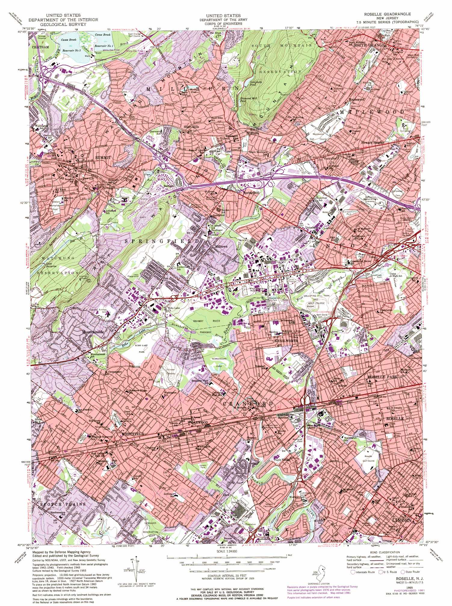
Roselle Topo Map New Jersey
To zoom in, hover over the map of Roselle
USGS Topo Quad 40074f3 - 1:24,000 scale
| Topo Map Name: | Roselle |
| USGS Topo Quad ID: | 40074f3 |
| Print Size: | ca. 21 1/4" wide x 27" high |
| Southeast Coordinates: | 40.625° N latitude / 74.25° W longitude |
| Map Center Coordinates: | 40.6875° N latitude / 74.3125° W longitude |
| U.S. State: | NJ |
| Filename: | o40074f3.jpg |
| Download Map JPG Image: | Roselle topo map 1:24,000 scale |
| Map Type: | Topographic |
| Topo Series: | 7.5´ |
| Map Scale: | 1:24,000 |
| Source of Map Images: | United States Geological Survey (USGS) |
| Alternate Map Versions: |
Roselle NJ 1947 Download PDF Buy paper map Roselle NJ 1955, updated 1958 Download PDF Buy paper map Roselle NJ 1955, updated 1964 Download PDF Buy paper map Roselle NJ 1955, updated 1972 Download PDF Buy paper map Roselle NJ 1955, updated 1982 Download PDF Buy paper map Roselle NJ 1995, updated 1998 Download PDF Buy paper map Roselle NJ 2011 Download PDF Buy paper map Roselle NJ 2014 Download PDF Buy paper map Roselle NJ 2016 Download PDF Buy paper map |
1:24,000 Topo Quads surrounding Roselle
Dover |
Boonton |
Pompton Plains |
Paterson |
Hackensack |
Mendham |
Morristown |
Caldwell |
Orange |
Weehawken |
Bernardsville |
Chatham |
Roselle |
Elizabeth |
Jersey City |
Bound Brook |
Plainfield |
Perth Amboy |
Arthur Kill |
The Narrows |
Monmouth Junction |
New Brunswick |
South Amboy |
Keyport |
Sandy Hook |
> Back to 40074e1 at 1:100,000 scale
> Back to 40074a1 at 1:250,000 scale
> Back to U.S. Topo Maps home
Roselle topo map: Gazetteer
Roselle: Airports
Ravens Nest Heliport elevation 32m 104′Union County elevation 30m 98′
Roselle: Bridges
Chatham Bridge elevation 56m 183′Roselle: Cliffs
Hawk Hill elevation 103m 337′Roselle: Crossings
Interchange 135 elevation 24m 78′Interchange 136 elevation 18m 59′
Interchange 137 elevation 25m 82′
Interchange 138 elevation 26m 85′
Interchange 139 elevation 18m 59′
Interchange 139A elevation 24m 78′
Interchange 140 elevation 31m 101′
Interchange 141 elevation 24m 78′
Interchange 45 elevation 97m 318′
Interchange 48 elevation 36m 118′
Interchange 49 elevation 26m 85′
Interchange 50 elevation 38m 124′
Interchange 51 elevation 45m 147′
Roselle: Dams
Bloodgoods Pond Dam elevation 11m 36′Briant Park Dam elevation 57m 187′
Campbells Pond Dam elevation 62m 203′
Jacksons Pond Dam elevation 11m 36′
Shackamaxon Dam elevation 23m 75′
Roselle: Falls
Maple Falls elevation 98m 321′Roselle: Lakes
Canoe Brook Reservoir Number 1 elevation 49m 160′Canoe Brook Reservoir Number 2 elevation 55m 180′
Echo Lake elevation 30m 98′
Roselle: Parks
Biertuempful Park elevation 37m 121′Blackbrook Park elevation 30m 98′
Briant Park elevation 85m 278′
Brightwood Park elevation 67m 219′
Brookside Park elevation 42m 137′
Clark Memorial Park elevation 49m 160′
Echo Lake Park elevation 46m 150′
Edison Recreation Center elevation 91m 298′
Elizabeth River Parkway elevation 15m 49′
Fox Hill Reserve elevation 135m 442′
Friberger Park elevation 39m 127′
Grove Park elevation 66m 216′
Henshaw Playground elevation 35m 114′
Hidden Valley Park elevation 118m 387′
Irwin Playground elevation 44m 144′
Kawameeh Park elevation 16m 52′
Lenape Park elevation 23m 75′
Maplecrest Park elevation 71m 232′
Meadowland Park elevation 48m 157′
Memorial Field elevation 24m 78′
Memorial Park elevation 33m 108′
Metro Homes Field elevation 68m 223′
Mindowaskin Park elevation 36m 118′
Nomahegan Park elevation 21m 68′
Olympic Park elevation 73m 239′
Rahway River Parkway elevation 23m 75′
Second Ward Park elevation 11m 36′
Slayton Field elevation 164m 538′
Soldiers Memorial Field elevation 114m 374′
South Mountain Reservation elevation 159m 521′
Tamaques Reservation elevation 22m 72′
Tatlock Sports Complex elevation 70m 229′
Taylor Park elevation 35m 114′
Unami Park elevation 26m 85′
Underhill Field elevation 55m 180′
Watchung Reservation elevation 89m 291′
White Oak Ridge Park elevation 79m 259′
Wilson Park elevation 14m 45′
Roselle: Populated Places
Aldene elevation 24m 78′Baltusrol elevation 74m 242′
Brantwood elevation 98m 321′
Clark elevation 23m 75′
Cranford elevation 19m 62′
Cranford Junction elevation 24m 78′
Garwood elevation 26m 85′
Kenilworth elevation 34m 111′
Maplewood elevation 32m 104′
Millburn elevation 44m 144′
Milltown elevation 27m 88′
Mountainside elevation 46m 150′
Newark Heights elevation 69m 226′
Overlook elevation 116m 380′
Park Village elevation 28m 91′
Roselle elevation 23m 75′
Roselle Park elevation 23m 75′
Short Hills elevation 84m 275′
South Orange elevation 45m 147′
Springfield elevation 32m 104′
Staten Island Junction elevation 33m 108′
Summit elevation 61m 200′
Tremont Park elevation 91m 298′
Union elevation 30m 98′
Unionburg elevation 33m 108′
Vauxhall elevation 58m 190′
Westfield elevation 39m 127′
White Oak Ridge elevation 80m 262′
Winfield elevation 18m 59′
Wyoming elevation 74m 242′
Roselle: Post Offices
Cranford Post Office elevation 25m 82′Garwood Post Office elevation 26m 85′
Kenilworth Post Office elevation 36m 118′
Linden Post Office elevation 9m 29′
Roselle Park Post Office elevation 23m 75′
Roselle Post Office elevation 22m 72′
Short Hills Post Office elevation 64m 209′
Summit Post Office elevation 116m 380′
Roselle: Reservoirs
Bloodgoods Pond elevation 11m 36′Briant Pond elevation 57m 187′
Campbells Pond elevation 62m 203′
Diamond Mill Pond elevation 56m 183′
Jacksons Pond elevation 11m 36′
Shackamaxon Lake elevation 23m 75′
Roselle: Streams
Beech Brook elevation 70m 229′East Branch Rahway River elevation 71m 232′
Maple Brook elevation 59m 193′
Nomahegan Brook elevation 23m 75′
Roselle: Summits
Nook Hill elevation 92m 301′Roselle digital topo map on disk
Buy this Roselle topo map showing relief, roads, GPS coordinates and other geographical features, as a high-resolution digital map file on DVD:
Atlantic Coast (NY, NJ, PA, DE, MD, VA, NC)
Buy digital topo maps: Atlantic Coast (NY, NJ, PA, DE, MD, VA, NC)
 map DVD")