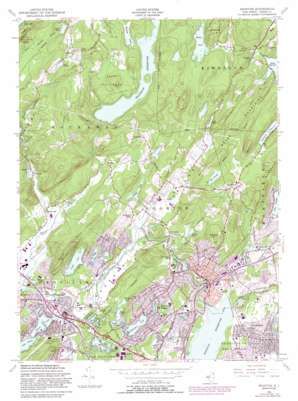
Boonton Topo Map New Jersey
To zoom in, hover over the map of Boonton
USGS Topo Quad 40074h4 - 1:24,000 scale
| Topo Map Name: | Boonton |
| USGS Topo Quad ID: | 40074h4 |
| Print Size: | ca. 21 1/4" wide x 27" high |
| Southeast Coordinates: | 40.875° N latitude / 74.375° W longitude |
| Map Center Coordinates: | 40.9375° N latitude / 74.4375° W longitude |
| U.S. State: | NJ |
| Filename: | o40074h4.jpg |
| Download Map JPG Image: | Boonton topo map 1:24,000 scale |
| Map Type: | Topographic |
| Topo Series: | 7.5´ |
| Map Scale: | 1:24,000 |
| Source of Map Images: | United States Geological Survey (USGS) |
| Alternate Map Versions: |
Boonton NJ 1947 Download PDF Buy paper map Boonton NJ 1954, updated 1955 Download PDF Buy paper map Boonton NJ 1954, updated 1962 Download PDF Buy paper map Boonton NJ 1954, updated 1972 Download PDF Buy paper map Boonton NJ 1954, updated 1982 Download PDF Buy paper map Boonton NJ 1954, updated 1988 Download PDF Buy paper map Boonton NJ 1954, updated 1988 Download PDF Buy paper map Boonton NJ 1995, updated 2000 Download PDF Buy paper map Boonton NJ 2011 Download PDF Buy paper map Boonton NJ 2014 Download PDF Buy paper map Boonton NJ 2016 Download PDF Buy paper map |
1:24,000 Topo Quads surrounding Boonton
> Back to 40074e1 at 1:100,000 scale
> Back to 40074a1 at 1:250,000 scale
> Back to U.S. Topo Maps home
Boonton topo map: Gazetteer
Boonton: Airports
Aircraft Radio Corporation Airport elevation 162m 531′Weichert Headquarters Heliport elevation 164m 538′
Boonton: Crossings
Interchange 38 elevation 159m 521′Interchange 39 elevation 152m 498′
Interchange 43 elevation 123m 403′
Interchange 44 elevation 124m 406′
Interchange 45 elevation 118m 387′
Boonton: Dams
Birchwood Lake Dam elevation 162m 531′Boonton Reservoir Dam elevation 80m 262′
Cedar Lake Dam elevation 162m 531′
Cooks Pond Dam elevation 162m 531′
Crystal Lake Dam elevation 162m 531′
Deer Pond Dam elevation 167m 547′
Dixons Pond Dam elevation 167m 547′
Durham Pond Dam elevation 262m 859′
Estling Lake Dam elevation 153m 501′
Griffith Pond Dam elevation 174m 570′
Indian Lake Dam elevation 155m 508′
Lake Juliet Dam elevation 171m 561′
Lake Valhalla Dam elevation 116m 380′
Mountain Lake Dam elevation 152m 498′
Patex Pond Dam elevation 85m 278′
Powerville Dam elevation 151m 495′
Rock Ridge Lake Dam elevation 161m 528′
Siebert Pond Dam elevation 290m 951′
Splitrock Pond Dam elevation 250m 820′
Stickle Pond Dam elevation 239m 784′
Sunset Lake Dam elevation 160m 524′
Wildwood Lake Dam elevation 146m 479′
Boonton: Lakes
Arrowhead Lake elevation 156m 511′Cooper Lake elevation 157m 515′
Diamond Springs Pond elevation 152m 498′
Egbert Lake elevation 262m 859′
Great Bay elevation 159m 521′
Kohlers Pond elevation 179m 587′
Lake Emma elevation 302m 990′
Lake Intervale elevation 113m 370′
Lake Ricabear elevation 202m 662′
Piscatells Pond elevation 187m 613′
Rainbow Lakes elevation 160m 524′
The Tarn elevation 164m 538′
Boonton: Parks
Gardner Field elevation 154m 505′Grace Lord Park elevation 128m 419′
Halsey A Fredrick Park elevation 127m 416′
Manor Park elevation 113m 370′
Muriel Hepner Park elevation 157m 515′
Richard M Wilcox Park elevation 177m 580′
Sheep Hill Park elevation 245m 803′
Silas Condict County Park elevation 215m 705′
Taft Memorial Field elevation 173m 567′
Tourne County Park elevation 203m 666′
Wildwood Field elevation 141m 462′
Boonton: Populated Places
Beach Glen elevation 158m 518′Boonton elevation 124m 406′
Denville elevation 154m 505′
Fox Hill elevation 126m 413′
Hibernia elevation 164m 538′
Lake Arrowhead elevation 158m 518′
Lake Hiawatha elevation 77m 252′
Lake Telemark elevation 218m 715′
Lyonsville elevation 228m 748′
Marcella elevation 328m 1076′
Meriden elevation 181m 593′
Montville elevation 95m 311′
Mountain Lakes elevation 146m 479′
Powerville elevation 156m 511′
Rockaway Valley elevation 156m 511′
Smoke Rise elevation 263m 862′
Taylortown elevation 200m 656′
Boonton: Reservoirs
Birchwood Lake elevation 162m 531′Boonton Reservoir elevation 80m 262′
Carters Pond elevation 237m 777′
Cedar Lake elevation 162m 531′
Cooks Pond elevation 162m 531′
Crystal Lake elevation 162m 531′
Deer Pond elevation 167m 547′
Dixons Pond elevation 167m 547′
Durham Pond elevation 262m 859′
Griffith Pond elevation 174m 570′
Hood Pond elevation 169m 554′
Indian Lake elevation 155m 508′
Jays Pond elevation 199m 652′
Lake Estling elevation 153m 501′
Lake Juliet elevation 171m 561′
Lake Tumble-In elevation 150m 492′
Lake Valhalla elevation 116m 380′
Little Mitten Lake elevation 290m 951′
Manor Lake elevation 107m 351′
Mountain Lake elevation 152m 498′
Patex Pond elevation 85m 278′
Rock Ridge Lake elevation 161m 528′
Splitrock Reservoir elevation 250m 820′
Stickle Pond elevation 239m 784′
Sunset Lake elevation 160m 524′
Taylortown Reservoir elevation 189m 620′
Wildwood Lake elevation 146m 479′
Boonton: Streams
Beaver Brook elevation 154m 505′Hibernia Brook elevation 157m 515′
Stony Brook elevation 146m 479′
White Meadow Brook elevation 157m 515′
Boonton: Summits
Bald Hill elevation 266m 872′Cobb Hill elevation 358m 1174′
Kikeout Mountain elevation 277m 908′
Pyramid Mountain elevation 283m 928′
Rock Pear Mountain elevation 289m 948′
Sheep Hill elevation 276m 905′
Stony Brook Mountains elevation 289m 948′
Boonton: Valleys
Rockaway Valley elevation 162m 531′Boonton digital topo map on disk
Buy this Boonton topo map showing relief, roads, GPS coordinates and other geographical features, as a high-resolution digital map file on DVD:
Atlantic Coast (NY, NJ, PA, DE, MD, VA, NC)
Buy digital topo maps: Atlantic Coast (NY, NJ, PA, DE, MD, VA, NC)


