Norristown Topo Map Pennsylvania
To zoom in, hover over the map of Norristown
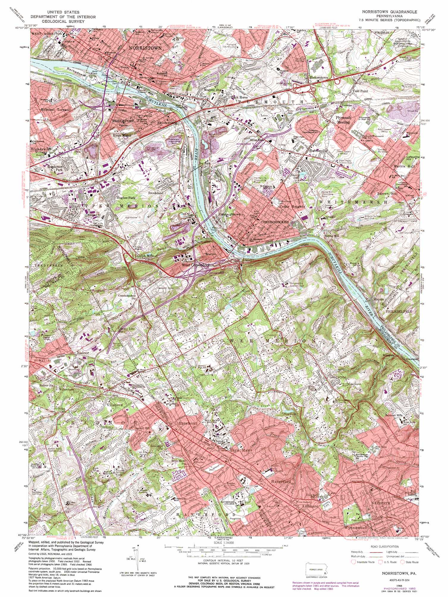
USGS Topo Quad 40075a3 - 1:24,000 scale
| Topo Map Name: | Norristown |
| USGS Topo Quad ID: | 40075a3 |
| Print Size: | ca. 21 1/4" wide x 27" high |
| Southeast Coordinates: | 40° N latitude / 75.25° W longitude |
| Map Center Coordinates: | 40.0625° N latitude / 75.3125° W longitude |
| U.S. State: | PA |
| Filename: | o40075a3.jpg |
| Download Map JPG Image: | Norristown topo map 1:24,000 scale |
| Map Type: | Topographic |
| Topo Series: | 7.5´ |
| Map Scale: | 1:24,000 |
| Source of Map Images: | United States Geological Survey (USGS) |
| Alternate Map Versions: |
Norristown PA 1952, updated 1954 Download PDF Buy paper map Norristown PA 1952, updated 1961 Download PDF Buy paper map Norristown PA 1966, updated 1968 Download PDF Buy paper map Norristown PA 1966, updated 1974 Download PDF Buy paper map Norristown PA 1966, updated 1983 Download PDF Buy paper map Norristown PA 1992, updated 1998 Download PDF Buy paper map Norristown PA 2010 Download PDF Buy paper map Norristown PA 2013 Download PDF Buy paper map Norristown PA 2016 Download PDF Buy paper map |
1:24,000 Topo Quads surrounding Norristown
Sassamansville |
Perkiomenville |
Telford |
Doylestown |
Buckingham |
Phoenixville |
Collegeville |
Lansdale |
Ambler |
Hatboro |
Malvern |
Valley Forge |
Norristown |
Germantown |
Frankford |
West Chester |
Media |
Lansdowne |
Philadelphia |
Camden |
Wilmington North |
Marcus Hook |
Bridgeport |
Woodbury |
Runnemede |
> Back to 40075a1 at 1:100,000 scale
> Back to 40074a1 at 1:250,000 scale
> Back to U.S. Topo Maps home
Norristown topo map: Gazetteer
Norristown: Airports
Flat Rock Airport elevation 15m 49′One Montgomery Plaza Heliport elevation 30m 98′
PQ-Lafayette Hill Heliport elevation 15m 49′
Radnor Heliport elevation 70m 229′
State Police Area One Heliport elevation 84m 275′
Sun Company-Radnor Heliport elevation 129m 423′
Norristown: Basins
Harmonville Impounding Basin elevation 39m 127′Spring Mill Impounding elevation 32m 104′
Swedeland Impounding elevation 29m 95′
Norristown: Bridges
Norristown Dam Bridge elevation 16m 52′William F Danne Hower Bridge elevation 16m 52′
Norristown: Crossings
Interchange 330 elevation 49m 160′Interchange 331A and 331B elevation 45m 147′
Interchange 332 elevation 53m 173′
Interchange 333 elevation 44m 144′
Interchange 334 elevation 46m 150′
Interchange 337 elevation 30m 98′
Pennsylvania Turnpike Interchange 25 elevation 43m 141′
Norristown: Dams
Dove Lake Dam elevation 71m 232′Griscom Dam elevation 71m 232′
Lake Lenape Dam elevation 124m 406′
Middle Dam elevation 32m 104′
Mitchell Dam elevation 100m 328′
Morris Estate Dam elevation 111m 364′
Morristown Dam elevation 16m 52′
Philadelphia Electric Dam elevation 16m 52′
Plymouth Dam elevation 18m 59′
Register Dam elevation 57m 187′
Sinott Dam elevation 108m 354′
Trout Lake Dam elevation 78m 255′
Upper Dam elevation 45m 147′
Norristown: Islands
Barbadoes Island elevation 23m 75′Norristown: Lakes
Dove Lake elevation 92m 301′Sherry Lake elevation 40m 131′
Norristown: Parks
Ashbridge Park elevation 106m 347′Bartasch Park elevation 34m 111′
Bob Holland Park elevation 45m 147′
Chiccino Field elevation 35m 114′
Colwell Park elevation 36m 118′
Elwell Field elevation 104m 341′
Encke Park elevation 101m 331′
Harriton Park elevation 86m 282′
Henry Lane Park elevation 63m 206′
Highland Farms Park elevation 123m 403′
Ithan Valley Park elevation 78m 255′
Kenealy Nature Park elevation 53m 173′
King Manor Park elevation 37m 121′
Lee Park elevation 24m 78′
Lower Merion Township Park elevation 64m 209′
Mary H Wood Park elevation 55m 180′
Merion View Park elevation 35m 114′
Merrill C Young Park elevation 47m 154′
Narbeth Playground elevation 97m 318′
Narbrook Park elevation 82m 269′
Natural Lands Trust Park elevation 73m 239′
Plymouth Meeting Park elevation 48m 157′
Preston Park elevation 120m 393′
Rosemont Park elevation 107m 351′
Schuylkill River Boat House Park elevation 30m 98′
Spring Mill County Park elevation 23m 75′
Spring Mill Park elevation 15m 49′
Sutcliff Park elevation 35m 114′
Swedeland Park elevation 24m 78′
Upper Merion Township Park elevation 61m 200′
Valley Forge Acres Park elevation 70m 229′
Villanova Stadium elevation 133m 436′
West Mill Creek Park elevation 48m 157′
Norristown: Populated Places
Andorra Springs elevation 58m 190′Andorra Woods elevation 58m 190′
Ardmore elevation 107m 351′
Barren Hill elevation 58m 190′
Belmont Hills elevation 79m 259′
Belmont Terrace elevation 73m 239′
Black Horse elevation 48m 157′
Bob White Farms elevation 131m 429′
Brandywine Village elevation 46m 150′
Bridgeport elevation 28m 91′
Bryn Mawr elevation 128m 419′
Candle Brook elevation 48m 157′
Cardinal View elevation 29m 95′
Cedar Heights elevation 63m 206′
Cherry Dale elevation 70m 229′
Cinnamon Hill elevation 62m 203′
Cold Point elevation 43m 141′
Connaughtown elevation 34m 111′
Conshohocken elevation 63m 206′
Conshohocken Station elevation 68m 223′
Corsons elevation 39m 127′
Crooked Lane Crossing elevation 59m 193′
Dartmouth Hills elevation 68m 223′
Eastburn Terrace elevation 66m 216′
Ernest elevation 29m 95′
Estates at Whitemarsh elevation 72m 236′
Executive Estates Park elevation 46m 150′
Forge Spring Village elevation 40m 131′
Fox Fields elevation 73m 239′
Garrett Hill elevation 132m 433′
Gladwyne elevation 103m 337′
Gulph Mills elevation 46m 150′
Gulph Mills Village elevation 62m 203′
Gulph Terrace elevation 105m 344′
Hamilton Court elevation 103m 337′
Harmonville elevation 59m 193′
Haverford elevation 97m 318′
Haverford Village elevation 101m 331′
Henderson elevation 49m 160′
Henderson Park elevation 54m 177′
Hickorytown elevation 54m 177′
Hollow Woods elevation 96m 314′
Hughes Park elevation 53m 173′
Ithan elevation 103m 337′
Ivy Rock elevation 34m 111′
Joshua Knoll elevation 56m 183′
Kings Manor elevation 53m 173′
Lafayette elevation 76m 249′
Lowell Hills elevation 41m 134′
Marble Hall elevation 66m 216′
Mechanicsville elevation 135m 442′
Merion Hills elevation 85m 278′
Merion View elevation 50m 164′
Mill Road elevation 27m 88′
Miquon elevation 42m 137′
Mogees Station elevation 34m 111′
Mogeetown elevation 45m 147′
Montrose Village elevation 108m 354′
Narberth elevation 95m 311′
Norlynne Court elevation 52m 170′
Norristown elevation 48m 157′
Oakwood at Plymouth elevation 54m 177′
Penn Valley elevation 98m 321′
Pleasant Valley Homes elevation 41m 134′
Plymouth Gardens elevation 59m 193′
Plymouth Hills elevation 68m 223′
Plymouth Meeting elevation 56m 183′
Prussian Woods elevation 77m 252′
Radnor elevation 132m 433′
Radnor Crossing elevation 128m 419′
Radnor Station elevation 121m 396′
Rampart Ridge elevation 118m 387′
Roseglen elevation 15m 49′
Rosemont elevation 117m 383′
Saint Marys Seminary elevation 136m 446′
School Side Manor elevation 62m 203′
Schoolside Manor elevation 62m 203′
Seven Stars elevation 36m 118′
Shainline elevation 52m 170′
Sherry Lake East elevation 57m 187′
Spring Mill elevation 19m 62′
Sussex Square elevation 55m 180′
Swedeland elevation 38m 124′
Swedesburg elevation 21m 68′
The Mermont elevation 119m 390′
The Reserve at Lafayette Springs elevation 69m 226′
The Wyndon elevation 98m 321′
Thomas Wynne elevation 100m 328′
Town Court elevation 59m 193′
Treemont Terrace elevation 26m 85′
Upton elevation 121m 396′
Valley Forge Acres elevation 70m 229′
Valley Forge Homes elevation 48m 157′
Villanova elevation 120m 393′
West Conshohocken elevation 65m 213′
West Spring Mills elevation 92m 301′
Westaway elevation 61m 200′
White Marsh Meadows elevation 50m 164′
Whitemarsh Green elevation 49m 160′
Whitemarsh Hunt elevation 64m 209′
Willowburn elevation 113m 370′
Wynnebrook Manor elevation 96m 314′
Wynnewood elevation 90m 295′
Wynnewood House elevation 102m 334′
Norristown: Post Offices
Conshohocken Post Office elevation 55m 180′Gladwyne Post Office elevation 116m 380′
Harmonville Branch Post Office elevation 49m 160′
Haverford Post Office elevation 109m 357′
King of Prussia Post Office elevation 62m 203′
Lafayette Hill Post Office (historical) elevation 79m 259′
Layfette Hill Post Office elevation 64m 209′
Miquon Post Office elevation 26m 85′
Narberth Post Office elevation 86m 282′
Norristown Post Office elevation 40m 131′
Plymouth Meeting Post Office elevation 55m 180′
Radnor Post Office (historical) elevation 103m 337′
Saint Davids Post Office elevation 118m 387′
Villanova Post Office elevation 113m 370′
West Conshohocken Branch Post Office elevation 38m 124′
William Penn Post Office (historical) elevation 25m 82′
Norristown: Reservoirs
Schuylkill River Reservoir elevation 16m 52′Norristown: Streams
Arrowmink Creek elevation 16m 52′Browns Run elevation 92m 301′
Diamond Run elevation 18m 59′
Doom Run elevation 71m 232′
Finn Run elevation 82m 269′
Foxes Run elevation 63m 206′
Gulph Creek elevation 15m 49′
Hardings Run elevation 108m 354′
Kirks Run elevation 84m 275′
Matsunk Creek elevation 16m 52′
Meadowbrook Run elevation 62m 203′
Mill Creek elevation 15m 49′
Plymouth Creek elevation 19m 62′
Sawmill Run elevation 15m 49′
Sawmill Run elevation 20m 65′
Stony Creek elevation 21m 68′
Trout Run elevation 63m 206′
Valley Run elevation 86m 282′
Norristown: Summits
Lafayette Hill elevation 72m 236′Norristown: Woods
Martha Brown Woods elevation 96m 314′Norristown digital topo map on disk
Buy this Norristown topo map showing relief, roads, GPS coordinates and other geographical features, as a high-resolution digital map file on DVD:
Atlantic Coast (NY, NJ, PA, DE, MD, VA, NC)
Buy digital topo maps: Atlantic Coast (NY, NJ, PA, DE, MD, VA, NC)
 map DVD")