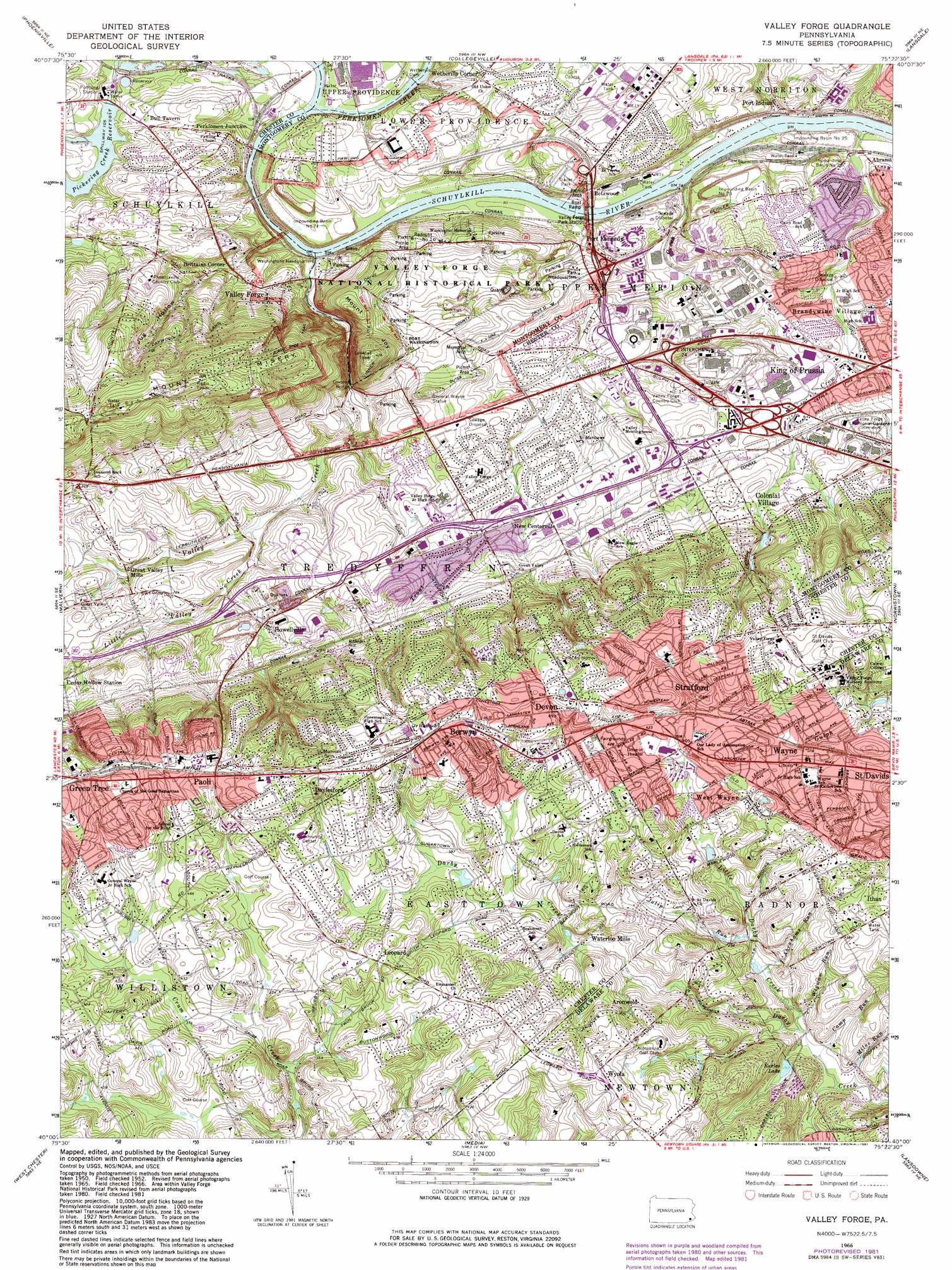
Valley Forge Topo Map Pennsylvania
To zoom in, hover over the map of Valley Forge
USGS Topo Quad 40075a4 - 1:24,000 scale
| Topo Map Name: | Valley Forge |
| USGS Topo Quad ID: | 40075a4 |
| Print Size: | ca. 21 1/4" wide x 27" high |
| Southeast Coordinates: | 40° N latitude / 75.375° W longitude |
| Map Center Coordinates: | 40.0625° N latitude / 75.4375° W longitude |
| U.S. State: | PA |
| Filename: | o40075a4.jpg |
| Download Map JPG Image: | Valley Forge topo map 1:24,000 scale |
| Map Type: | Topographic |
| Topo Series: | 7.5´ |
| Map Scale: | 1:24,000 |
| Source of Map Images: | United States Geological Survey (USGS) |
| Alternate Map Versions: |
Valley Forge PA 1952, updated 1953 Download PDF Buy paper map Valley Forge PA 1952, updated 1953 Download PDF Buy paper map Valley Forge PA 1952, updated 1958 Download PDF Buy paper map Valley Forge PA 1966, updated 1968 Download PDF Buy paper map Valley Forge PA 1966, updated 1974 Download PDF Buy paper map Valley Forge PA 1966, updated 1981 Download PDF Buy paper map Valley Forge PA 1966, updated 1981 Download PDF Buy paper map Valley Forge PA 1992, updated 1998 Download PDF Buy paper map Valley Forge PA 2010 Download PDF Buy paper map Valley Forge PA 2013 Download PDF Buy paper map Valley Forge PA 2016 Download PDF Buy paper map |
1:24,000 Topo Quads surrounding Valley Forge
Boyertown |
Sassamansville |
Perkiomenville |
Telford |
Doylestown |
Pottstown |
Phoenixville |
Collegeville |
Lansdale |
Ambler |
Downingtown |
Malvern |
Valley Forge |
Norristown |
Germantown |
Unionville |
West Chester |
Media |
Lansdowne |
Philadelphia |
Kennett Square |
Wilmington North |
Marcus Hook |
Bridgeport |
Woodbury |
> Back to 40075a1 at 1:100,000 scale
> Back to 40074a1 at 1:250,000 scale
> Back to U.S. Topo Maps home
Valley Forge topo map: Gazetteer
Valley Forge: Airports
Benson Heliport elevation 116m 380′Crouse Heliport elevation 36m 118′
Foxcatcher Heliport elevation 131m 429′
Hobson Airport elevation 146m 479′
Peco Berwyn Heliport elevation 71m 232′
Valley Forge Bicentennial Heliport elevation 71m 232′
Valley Forge: Basins
Impounding Basin Number Twenty-Five elevation 19m 62′Impounding Basin Number Twenty-Four elevation 30m 98′
Impounding Basin Number Twenty-One elevation 24m 78′
Impounding Basin Number Twenty-Two elevation 43m 141′
Valley Forge: Bridges
Betzwood Bridge elevation 15m 49′Knox-Valley Forge Dam Covered Bridge elevation 35m 114′
Martins Dam Bridge elevation 87m 285′
Valley Forge: Crossings
Interchange 326 elevation 48m 157′Interchange 326 elevation 45m 147′
Interchange 327 elevation 57m 187′
Interchange 328A elevation 51m 167′
Interchange 328B elevation 55m 180′
Pennsylvania Turnpike Interchange 24 elevation 47m 154′
Pennsylvania Turnpike Interchange 9 elevation 45m 147′
Valley Forge: Dams
Entrekin Dam elevation 122m 400′French Dam elevation 73m 239′
George H Earle Junior Dam elevation 77m 252′
Green Countrie Dam elevation 86m 282′
Martins Dam elevation 86m 282′
Martins Dam elevation 89m 291′
Mill Club Dam elevation 105m 344′
Mill Club Dam elevation 105m 344′
Oaks Dam elevation 24m 78′
Pickering Creek Dam elevation 25m 82′
Wetherills Dam elevation 21m 68′
Valley Forge: Lakes
Earles Lake elevation 79m 259′Valley Forge: Mines
Port Kennedy Quarry elevation 30m 98′Valley Forge: Parks
Betzwood Park elevation 49m 160′Devon Station elevation 139m 456′
Fort Washington (historical) elevation 60m 196′
General Wayne Statue elevation 87m 285′
Jenkins Arboretum elevation 126m 413′
Odorisio Park elevation 107m 351′
Skunk Hollow Park elevation 88m 288′
Strafford Park elevation 154m 505′
Tredyffrin Park elevation 79m 259′
Valley Forge National Historical Park elevation 47m 154′
Valley Forge National Historical Park Amphitheater elevation 45m 147′
Warren Filipone Memorial Park elevation 114m 374′
Valley Forge: Populated Places
Abrahams elevation 35m 114′Aronwold elevation 114m 374′
Beidler Knoll elevation 53m 173′
Berwyn elevation 150m 492′
Betzwood elevation 32m 104′
Blackburn Farm elevation 127m 416′
Brittains Corner elevation 44m 144′
Bull Tavern elevation 45m 147′
Buttonwood Farms elevation 136m 446′
Cannon Run elevation 47m 154′
Cannon Run West elevation 55m 180′
Chapel View Estates elevation 41m 134′
Chesterbrook elevation 49m 160′
Colonial Village elevation 77m 252′
Colonial Way elevation 129m 423′
Continental Arms elevation 44m 144′
Crestwyck elevation 59m 193′
David Estates elevation 142m 465′
Daylesford elevation 140m 459′
Daylesford Lake elevation 65m 213′
Deepdale elevation 146m 479′
Devon elevation 152m 498′
Devon Hunt elevation 130m 426′
Dubarry Estates elevation 110m 360′
Duffryn Mawr elevation 154m 505′
Freedom View elevation 77m 252′
Garden elevation 68m 223′
Glen Craig elevation 83m 272′
Glen Hardie elevation 39m 127′
Glenn Rose elevation 27m 88′
Green Countrie Village elevation 97m 318′
Green Tree elevation 154m 505′
Harrison Estate elevation 115m 377′
Hidden Valley elevation 28m 91′
Howellville elevation 61m 200′
Kerwood elevation 64m 209′
King of Prussia elevation 61m 200′
Lafayette Park elevation 71m 232′
Leopard elevation 137m 449′
Leopard Farms elevation 123m 403′
Leopard Lakes elevation 116m 380′
Lexton Woods elevation 113m 370′
Meadows at Valley Forge elevation 54m 177′
New Centerville elevation 60m 196′
Paoli elevation 155m 508′
Paoli Gardens elevation 151m 495′
Paoli Manor elevation 168m 551′
Paoli Road elevation 70m 229′
Paoli Woods Foxwood elevation 131m 429′
Pawling Woods elevation 43m 141′
Perkiomen Junction elevation 48m 157′
Powderhorn Knoll elevation 53m 173′
Rennyson elevation 75m 246′
Saint Davids elevation 107m 351′
Shand Vassar elevation 153m 501′
Strafford elevation 134m 439′
Sunwood Farm elevation 63m 206′
Sweet Briar elevation 36m 118′
The Commons at Valley Forge elevation 47m 154′
Trent Manor elevation 74m 242′
Treyburn elevation 72m 236′
Trinity House elevation 162m 531′
Valley Forge elevation 75m 246′
Valley Forge Estates elevation 74m 242′
Valley Forge Meadows elevation 67m 219′
Valley Forge Mountain elevation 152m 498′
Valley Forge Mountain North elevation 133m 436′
Valley Forge Towers elevation 35m 114′
Valley Forge Trailer Park elevation 30m 98′
Valley Forge Woods elevation 74m 242′
Valley Greene elevation 74m 242′
Village Builders elevation 160m 524′
Washington Park elevation 52m 170′
Washingtons Crossing elevation 60m 196′
Waterloo Mills elevation 98m 321′
Wayne elevation 117m 383′
Waynes Brooke elevation 120m 393′
Waynesborough Woods elevation 139m 456′
Waynewoods elevation 127m 416′
West Wayne elevation 118m 387′
Westover Club elevation 49m 160′
Wetherills Corner elevation 62m 203′
Weyhill elevation 61m 200′
Whitehorse Farms elevation 139m 456′
Wyola elevation 142m 465′
Valley Forge: Post Offices
Chester Valley Post Office (historical) elevation 64m 209′Devon Post Office elevation 140m 459′
Paoli Post Office elevation 159m 521′
Valley Forge Post Office elevation 56m 183′
Valley Forge: Reservoirs
Club Lake elevation 105m 344′Lake Green Countrie elevation 86m 282′
Pickering Creek Reservoir elevation 30m 98′
Valley Forge: Streams
Abrahams Run elevation 77m 252′Camp Run elevation 70m 229′
Crabby Creek elevation 45m 147′
Crow Creek elevation 15m 49′
East Branch Crum Creek elevation 118m 387′
Elliotts Run elevation 19m 62′
Evans Run elevation 109m 357′
Fox Run elevation 95m 311′
Green Tree Run elevation 124m 406′
Grubb Mill Run elevation 102m 334′
Indian Creek elevation 16m 52′
Julip Run elevation 81m 265′
Lewis Run elevation 113m 370′
Little Darby Creek elevation 69m 226′
Little Valley Creek elevation 39m 127′
Miles Run elevation 64m 209′
Mine Run elevation 21m 68′
Perkiomen Creek elevation 21m 68′
Saw Mill Run elevation 69m 226′
Thomas Run elevation 126m 413′
Trout Creek elevation 15m 49′
Valley Creek elevation 18m 59′
Waynesborough Run elevation 109m 357′
Wigwam Run elevation 70m 229′
Valley Forge: Summits
Mount Joy elevation 79m 259′Mount Misery elevation 176m 577′
Valley Forge: Valleys
Jug Hollow elevation 24m 78′Valley Creek Gorge elevation 18m 59′
Valley Forge digital topo map on disk
Buy this Valley Forge topo map showing relief, roads, GPS coordinates and other geographical features, as a high-resolution digital map file on DVD:
Atlantic Coast (NY, NJ, PA, DE, MD, VA, NC)
Buy digital topo maps: Atlantic Coast (NY, NJ, PA, DE, MD, VA, NC)
 map DVD")